Torbanlea facts for kids
Quick facts for kids TorbanleaQueensland |
|||||||||||||||
|---|---|---|---|---|---|---|---|---|---|---|---|---|---|---|---|

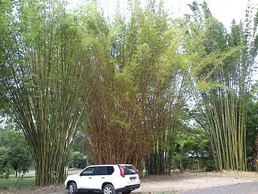
Giant bamboo, Torbanlea, 2014
|
|||||||||||||||
| Population | 841 (2021 census) | ||||||||||||||
| • Density | 29.61/km2 (76.7/sq mi) | ||||||||||||||
| Postcode(s) | 4662 | ||||||||||||||
| Area | 28.4 km2 (11.0 sq mi) | ||||||||||||||
| Time zone | AEST (UTC+10:00) | ||||||||||||||
| Location |
|
||||||||||||||
| LGA(s) | Fraser Coast Region | ||||||||||||||
| State electorate(s) | Maryborough | ||||||||||||||
| Federal Division(s) | Hinkler | ||||||||||||||
|
|||||||||||||||
Torbanlea is a small country town in the Fraser Coast Region of Queensland, Australia. It's a quiet place where people live and work. In 2021, about 841 people called Torbanlea home.
Contents
Exploring Torbanlea's Location
The Burrum River forms the western and northern edges of Torbanlea. The main part of the town is located near the river's northern side. The North Coast railway line runs through Torbanlea, heading from the south-east to the north. You can find the Torbanlea railway station right in the middle of town.
The Bruce Highway, a major road, also goes through the area. It runs south of the railway line and goes around the town centre. Most of the land outside the town is used for farming, especially near the river and highway. Some parts of the locality, especially in the south-east, are hilly and covered in natural bushland.
A Look at Torbanlea's Past
The name Torbanlea is thought to have come from James Robertson, a mining manager. He might have named it after a place called Torbane Hill in Scotland.
Early Buildings and Schools
Torbanlea State School first opened its doors on 26 September 1887. It has been teaching local children for over 130 years!
Churches were also an important part of early Torbanlea. The Torbanlea Primitive Methodist Church opened in 1891. Before that, services were held under a tree or in a local hall. This church later became the Torbanlea Methodist Church. In 1977, it joined with other churches to become the Torbanlea Uniting Church. This church is now closed, but the building at 12 Gympie Street is still there today.
St Stephen's Anglican Church also opened around 1896. It closed in 1988. This church building at 10 Crawford Street is also still standing, but it has been changed into a private home.
Important Events in History
In 1900, there was a sad event at a nearby colliery (coal mine) where five workers lost their lives.
In May 1984, a new section of the Bruce Highway was opened. This new road went around Torbanlea, so traffic no longer had to drive through the town's main street, Robertson Street. The nearby town of Howard also got a bypass at the same time.
Torbanlea's Economy
For a long time, Torbanlea was known as a coal mining town. Today, things are changing! There are plans to build more than 60 trains at a special facility in Torbanlea. These trains will be used for the 2032 Brisbane Olympic Games. This is a huge project and the biggest investment in train manufacturing for the state. The facilities where the trains will be built cost about $239 million to create.
Learning in Torbanlea
Torbanlea State School is a primary school for students from Prep to Year 6. It's located on Pialba Road. In 2018, the school had 305 students and a team of teachers and staff. It also has a special program for students who need extra support.
There isn't a high school right in Torbanlea. Older students usually go to high schools in nearby towns. The closest government high schools are Hervey Bay State High School in Pialba (part of Hervey Bay) or Aldridge State High School in Maryborough.
Community Amenities
The Howard/Torbanlea Uniting Church is located in Coal Street, Howard. It's part of a larger church group called the Mary Burnett Presbytery of the Uniting Church in Australia.


