Howard, Queensland facts for kids
Quick facts for kids HowardQueensland |
|||||||||||||||
|---|---|---|---|---|---|---|---|---|---|---|---|---|---|---|---|

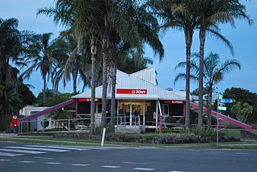
Post office at Howard in 2008, which in 2021-2024 was a cafe.
|
|||||||||||||||
| Population | 1,394 (2021 census) | ||||||||||||||
| • Density | 30.37/km2 (78.7/sq mi) | ||||||||||||||
| Postcode(s) | 4659 | ||||||||||||||
| Area | 45.9 km2 (17.7 sq mi) | ||||||||||||||
| Time zone | AEST (UTC+10:00) | ||||||||||||||
| Location |
|
||||||||||||||
| LGA(s) | Fraser Coast Region | ||||||||||||||
| State electorate(s) | Maryborough | ||||||||||||||
| Federal Division(s) | Hinkler | ||||||||||||||
|
|||||||||||||||
Howard is a small town in the Fraser Coast Region of Queensland, Australia. It's a rural area. The town is located about 284 kilometers (176 miles) north of Brisbane. It is also 37 kilometers (23 miles) west of Hervey Bay. In 2021, about 1,394 people lived in Howard.
Contents
Discovering Howard's Location
Howard is on the west side of the Burrum River. On the east side of the river is the town of Torbanlea. These two towns are only about 5.1 kilometers (3.2 miles) apart. Because they are so close, they are sometimes called "twin towns."
Maria Creek flows through Howard. It then empties into the Burrum River. The Bruce Highway passes by the edge of the town. Queensland's North Coast railway line also runs through the center of Howard. The main streets in town are Steley Street and William Street.
Howard's Past: A Look at History
The town was first known as Steley. It was named after Abel Steley. He was one of the first people to mine coal in the area. Later, the town was renamed Howard. This was in honor of William Howard, another important coal mining pioneer.
Early Coal Mining in Howard
Abel Steley started mining coal in 1856. He faced many challenges. But he eventually created a successful company called Queensland Collieries Company. In 1877, George Howard and his son William started their own mine, the Howard Colliery.
For many years, coal from the Burrum area was sent to Maryborough. From there, it was loaded onto boats. In 1877, a special steamer boat called Barbara and Jane began carrying coal on the Burrum River. In 1883, a railway line opened from Maryborough to the Burrum River. This made it easier to transport coal. The coal from these mines also powered the Howard power station from 1951 to 1980.
Important Places and Dates
The Howard Cemetery, also known as Howard Remembrance Park, opened in 1876. The first post office in the area opened in 1878. It was renamed Howard Post Office in 1883.
Howard State School first opened in 1879. It was originally called Burrum Provisional School. It changed its name to Howard State School in 1884.
St Matthew's Anglican Church opened in 1883. During World War II, the church hall was used as a field hospital. A Primitive Methodist Church opened in 1884. Today, it is known as the Howard Uniting Church. In 2024, the church celebrated its 140th anniversary.
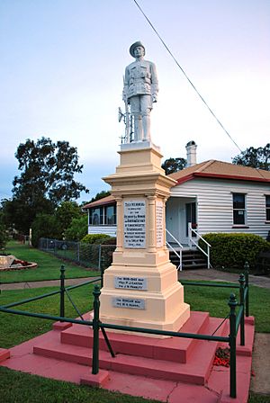
The Howard War Memorial was officially revealed in 1921. It's special because the soldier statue was made in Italy. It shows a soldier wearing an Italian uniform.
In 1984, the Bruce Highway was rerouted around Howard. Before this, the highway went right through the town.
The Howard Library opened in 2000. It was updated in 2014. An old wooden footbridge over the railway line was taken down in 2016. It was too expensive to keep safe.
Howard's Heritage Sites
Howard has a few places that are listed as important heritage sites. This means they are protected because of their historical value.
- William Street: Howard War Memorial
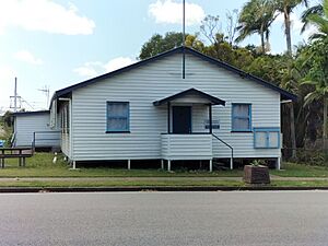
- 23 William Street: Brooklyn House
Learning in Howard
Howard State School is a primary school for students from Prep to Year 6. It is located at 108 William Street. In 2018, about 108 students attended the school.
There isn't a high school in Howard. Students usually go to secondary schools in nearby towns. These include Childers, Hervey Bay, or Maryborough.
What's in Howard: Amenities
Steley Street has many useful places. You can find a skatepark, a playground for kids, and a kindergarten. There's also the Howard Sawmill, which makes hardwood. Shops like a drapery store, hairdresser, and VanCootens Grocery are also on this street. The QCWA hall is here too.
If you travel by RV, there's a place to stop for 48 hours on Steley Street. The Howard Railway Station is also on Steley Street. You can catch trains like the Spirit of Queensland or the Tilt Train from here if you book ahead.
The Fraser Coast Regional Council runs a public library at 56 Steley Street.
William Street is another busy street. It has a post office, milk bar, butcher, bakery, and pharmacy. You'll also find a hotel, bottle shop, newsagency, and an IGA supermarket. There's a vet clinic and a doctor's office. The Howard Police Station is at 98 William Street. The Howard Ambulance Station is nearby on Thomas Street.
The Howard/Torbanlea Uniting Church is on Coal Street. The Burrum District Golf Club is on Gregory Street. The local Bowls Club is in Torbanlea.
Howard also has a public boat ramp on the Burrum River. It's managed by the Fraser Coast Regional Council.
Fun Things to Do in Howard: Attractions
When you walk around Howard, you can find information boards. They tell you about the War Memorial and the town's mining history. They also explain how Bellert Park and the Tom & Minnie Young Memorial Hall got their names.
The Burrum District Museum is open on Tuesdays, Wednesdays, and Saturdays. Brooklyn House is also open to visitors from Thursday to Sunday.
The Walk of Achievers celebrates fourteen people who used to live in Howard.
The Burrum Coal Discovery Festival, or Coalfest, is held every July. It's a fun event about the town's coal mining past.
The Howard Country Market is held on the first Saturday of every month, except January. It's at the community center. This market is very big, with over 100 stalls selling all sorts of items.
Famous People from Howard
- Andrew Fisher: He was the second Labor Prime Minister of Australia. He built and lived in a house that is still standing today.
- Annabelle Rankin: She was the first woman from Queensland to be in the Parliament of Australia. She was also the first woman to hold a federal government job. She lived in Brooklyn House.
- Colin Rankin: He was the chairman of the Shire of Howard. He also represented Burrum in the Queensland Parliament. He lived in Brooklyn House.
- Eric Harris (rugby league): A rugby league player who played for teams in Toowoomba, Brisbane, Queensland, and England.
 | Aurelia Browder |
 | Nannie Helen Burroughs |
 | Michelle Alexander |


