
Tosashimizu, Kōchi facts for kids
Quick facts for kids
Tosashimizu
土佐清水市
|
|||||||||||||||
|---|---|---|---|---|---|---|---|---|---|---|---|---|---|---|---|

View of Pacific Ocean and Cape Ashizuri
|
|||||||||||||||
|
|||||||||||||||
 |
|||||||||||||||

Tosashimizu
Location in Japan
|
|||||||||||||||
| Country | Japan | ||||||||||||||
| Region | Shikoku | ||||||||||||||
| Prefecture | Kōchi | ||||||||||||||
| Area | |||||||||||||||
| • Total | 266.34 km2 (102.83 sq mi) | ||||||||||||||
| Population
(31 July 2022)
|
|||||||||||||||
| • Total | 12,407 | ||||||||||||||
| • Density | 46.5833/km2 (120.650/sq mi) | ||||||||||||||
| Time zone | UTC+09:00 (JST) | ||||||||||||||
| City hall address | 11-2 Tenjinmachi, Tosashimizu-shi, Kōchi-ken 787-0392 | ||||||||||||||
| Climate | Cfa | ||||||||||||||
|
|||||||||||||||


Tosashimizu (土佐清水市 (Tosashimizu-shi)) is a city in the southwest of Kōchi Prefecture, Japan. As of July 2022, about 12,407 people live here. The city covers an area of 266.34 square kilometers. It's a place with beautiful nature and a strong connection to the ocean.
Contents
Exploring Tosashimizu's Location
Tosashimizu is located in the far western part of Kochi Prefecture. This area is on the island of Shikoku. Some parts of the city are inside the Ashizuri-Uwakai National Park. This park is known for its beautiful coastal scenery.
Cities and Towns Nearby
Tosashimizu shares its borders with a few other places in Kōchi Prefecture:
- Mihara
- Ōtsuki
- Shimanto City
- Sukumo
Tosashimizu's Climate and Weather
Tosashimizu has a humid subtropical climate. This means it has hot, humid summers and cool winters. There is a lot of rain throughout the year, especially in June and July.
The average yearly temperature in Tosashimizu is about 18.4°C (65.1°F). The average yearly rainfall is 2563.9 mm (100.94 in). August is usually the hottest month, with temperatures around 27.7°C (81.9°F). January is the coldest, at about 8.9°C (48.0°F).
The highest temperature ever recorded was 35.5°C (95.9°F) in July 1942. The coldest was -5.0°C (23.0°F) in February 1981.
| Climate data for Cape Ashizuri, Tosashimizu (1991−2020 normals, extremes 1940−present) | |||||||||||||
|---|---|---|---|---|---|---|---|---|---|---|---|---|---|
| Month | Jan | Feb | Mar | Apr | May | Jun | Jul | Aug | Sep | Oct | Nov | Dec | Year |
| Record high °C (°F) | 22.5 (72.5) |
22.3 (72.1) |
25.2 (77.4) |
26.9 (80.4) |
31.3 (88.3) |
31.7 (89.1) |
35.5 (95.9) |
35.0 (95.0) |
33.8 (92.8) |
31.3 (88.3) |
27.0 (80.6) |
23.7 (74.7) |
35.5 (95.9) |
| Mean daily maximum °C (°F) | 12.4 (54.3) |
13.4 (56.1) |
16.2 (61.2) |
20.1 (68.2) |
23.4 (74.1) |
25.4 (77.7) |
28.9 (84.0) |
30.4 (86.7) |
28.3 (82.9) |
24.3 (75.7) |
19.7 (67.5) |
14.7 (58.5) |
21.4 (70.6) |
| Daily mean °C (°F) | 8.9 (48.0) |
9.8 (49.6) |
12.8 (55.0) |
16.9 (62.4) |
20.4 (68.7) |
23.0 (73.4) |
26.5 (79.7) |
27.7 (81.9) |
25.5 (77.9) |
21.4 (70.5) |
16.5 (61.7) |
11.3 (52.3) |
18.4 (65.1) |
| Mean daily minimum °C (°F) | 5.5 (41.9) |
6.2 (43.2) |
9.1 (48.4) |
13.5 (56.3) |
17.6 (63.7) |
20.9 (69.6) |
24.6 (76.3) |
25.6 (78.1) |
23.2 (73.8) |
18.6 (65.5) |
13.4 (56.1) |
7.9 (46.2) |
15.5 (59.9) |
| Record low °C (°F) | −4.3 (24.3) |
−5.0 (23.0) |
−3.4 (25.9) |
3.2 (37.8) |
9.2 (48.6) |
14.6 (58.3) |
17.3 (63.1) |
20.1 (68.2) |
14.0 (57.2) |
7.3 (45.1) |
2.4 (36.3) |
−2.0 (28.4) |
−5.0 (23.0) |
| Average precipitation mm (inches) | 98.6 (3.88) |
116.4 (4.58) |
183.9 (7.24) |
221.8 (8.73) |
232.6 (9.16) |
400.2 (15.76) |
222.8 (8.77) |
231.5 (9.11) |
362.4 (14.27) |
254.2 (10.01) |
146.9 (5.78) |
97.0 (3.82) |
2,563.9 (100.94) |
| Average snowfall cm (inches) | trace | trace | 0 (0) |
0 (0) |
0 (0) |
0 (0) |
0 (0) |
0 (0) |
0 (0) |
0 (0) |
0 (0) |
trace | 1 (0.4) |
| Average precipitation days (≥ 1.0 mm) | 5.8 | 7.3 | 10.8 | 10.0 | 10.4 | 14.1 | 10.5 | 10.7 | 12.4 | 9.7 | 8.3 | 6.1 | 116.1 |
| Average snowy days (≥ 1 cm) | 0.2 | 0.1 | 0 | 0 | 0 | 0 | 0 | 0 | 0 | 0 | 0 | 0.1 | 0.4 |
| Average relative humidity (%) | 58 | 59 | 62 | 66 | 73 | 83 | 84 | 82 | 77 | 69 | 65 | 60 | 70 |
| Mean monthly sunshine hours | 180.5 | 173.3 | 190.1 | 196.0 | 190.5 | 131.0 | 196.6 | 233.8 | 175.8 | 179.7 | 167.0 | 174.1 | 2,190.5 |
| Source: Japan Meteorological Agency | |||||||||||||
Tosashimizu's Population Over Time
According to Japanese census data, Tosashimizu had 12,388 people in 2020. The city has been counting its population since 1920. Among the 11 cities in Kochi Prefecture, Tosashimizu has the second-lowest population.
| Historical population | ||
|---|---|---|
| Year | Pop. | ±% |
| 1920 | 22,666 | — |
| 1925 | 24,342 | +7.4% |
| 1930 | 25,795 | +6.0% |
| 1935 | 26,270 | +1.8% |
| 1940 | 24,161 | −8.0% |
| 1945 | 29,882 | +23.7% |
| 1950 | 31,656 | +5.9% |
| 1955 | 31,623 | −0.1% |
| 1960 | 29,944 | −5.3% |
| 1965 | 26,725 | −10.8% |
| 1970 | 24,122 | −9.7% |
| 1975 | 24,856 | +3.0% |
| 1980 | 24,252 | −2.4% |
| 1985 | 23,014 | −5.1% |
| 1990 | 21,182 | −8.0% |
| 1995 | 19,582 | −7.6% |
| 2000 | 18,512 | −5.5% |
| 2005 | 17,281 | −6.6% |
| 2010 | 16,029 | −7.2% |
| 2015 | 13,778 | −14.0% |
| 2020 | 12,388 | −10.1% |
| Tosashimizu population statistics | ||
A Brief History of Tosashimizu
The area of Tosashimizu was once part of ancient Tosa Province. During the Edo period (1603-1868), the Yamauchi clan ruled this area from their castle in Kōchi.
After the Meiji Restoration in 1868, Japan created a new system for towns and villages. On April 1, 1889, the village of Shimatsu was formed. It later changed its name to Shimizu and became a town in 1924. On August 1, 1954, Shimizu joined with three nearby towns: Shimokawaguchi, Misaki, and Shimokae. Together, they formed the city of Tosashimizu.
Tosashimizu's Economy and Industries
The biggest industry in Tosashimizu is fishing, especially deep-sea fishing. A special seafood product called Sōdabushi is very important here. It's locally known as mejikabushi. Tosashimizu produces about 70% of all sōdabushi in Japan. It's made from frigate mackerel, similar to how katsuobushi is made. Local fishermen also sell blue mackerel, which they call "Tosano shimizusaba."
The Osaka Aquarium Kaiyukan has a special research center in Tosashimizu. It's called the Osaka Aquarium Biological Research Institute of Iburi Center (OBIC). This center provides many of the marine animals displayed at the aquarium in Osaka. They also do scientific studies, using a huge 1,600-ton tank.
Education in Tosashimizu
Tosashimizu has six public elementary schools and one public middle school. These schools are run by the city government. There is also one public high school, which is managed by the Kōchi Prefectural Board of Education.
Getting Around Tosashimizu
No Passenger Trains
Tosashimizu does not have its own train station for passengers. The closest train station is Nakamura Station. This station is in Shimanto city. You can take a bus from Tosashimizu to Nakamura Station, which takes about 60 minutes.
Major Roadways
 National Route 321
Sister Cities of Tosashimizu
Tosashimizu has special friendships with other cities around the world. These are called sister cities:
 Fairhaven, Massachusetts, United States (since 1987)
- New Bedford, Massachusetts, United States (since 1987)
 Tomigusuku, Okinawa, Japan (since February 1993)
Fun Places to Visit in Tosashimizu
Cape Ashizuri: A Natural Wonder
The coastline of Tosashimizu stretches for 70 kilometers. It attracts over 800,000 tourists every year. Ashizuri-Uwakai National Park includes Cape Ashizuri, the largest peninsula in the area. Tosashimizu is the closest city to this cape, which sticks out into the Pacific Ocean.
Cape Ashizuri is 80 meters (262 feet) above sea level. The peninsula is covered with subtropical plants like camellia and holm oak. You can also see colonies of Livistona palms. The sea here is a great place for fishing, especially for skipjack tuna. Cape Ashizuri is known as the southernmost point on Shikoku island.
The Tatsukushi area has interesting rock formations made of sandstone and mudstone. A famous gate-shaped rock, Hakusandōmon, is on the west side of the cape. There's also the Tōjindaba Site, a prehistoric place with a stone circle, located on a hill near Cape Ashizuri.
Birthplace of Nakahama Manjirō
On the western shore of the Ashizuri peninsula is the village of Nakanohama. This is where Nakahama Manjirō was born. He was one of the first Japanese people to travel to the United States. In 1841, Manjirō, a young fisherman, was shipwrecked. He was rescued by Captain William H. Whitfield from Fairhaven, Massachusetts.
Captain Whitfield brought Manjirō back to Fairhaven and New Bedford. Manjirō lived there for several years before returning to Japan. Because of this history, Tosashimizu became sister cities with Fairhaven and New Bedford in 1987. Manjirō became famous as John Manjirō after a novel was written about his life.
Exciting Wildlife Tours
There are several fun wildlife tours available around the Ashizuri peninsula. You can even swim with some amazing sea creatures!
Swimming with Whale Sharks
Whale sharks swim near the Ashizuri Peninsula between June and September. Some are kept in a large cage about 300 meters (984 feet) offshore. You can swim near them!
Ocean Sunfish Swim
From April to the end of July, ocean sunfish are kept in a large net cage. When the water gets warmer, they are released back into the ocean.
Whale Watching Adventures
You can also go whale watching on the east side of the peninsula. Tours start from Kubotsu town and Shimonokae.
The Shikoku Pilgrimage Route
The Shikoku Pilgrimage is a famous journey that passes through Tosashimizu. The longest part of the route, 80.7 kilometers (50.1 miles), is between the 37th temple (Iwamoto-ji (岩本寺)) and the 38th temple (Kongōfuku-ji (金剛福寺)) on Cape Ashizuri.
As pilgrims walk down from Itsuta pass (伊豆田峠) towards Tosashimizu, they find Shinnenan (真念庵). This is a small resting place about 28 kilometers (17 miles) from Kongōfuku-ji. It was made to offer free lodging for pilgrims. They could also leave their bags here while visiting Kongōfuku-ji, then come back and continue to the 39th temple, Enkō-ji, which is 50.8 kilometers (31.6 miles) away.
Roadside Stations for Travelers
Mejikano sato Tosashimizu roadside station is located near the beautiful Tatsukushi area, along Route 321. "Mejika" is the local word for frigate mackerel. They make and sell sōdabushi here, which is a main seafood product of the city. You can even see how it's made at a factory behind the store. Fresh farm produce is also sold at this roadside station.
Images for kids
-
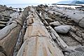
Tatsukushi's unique rock formations
-
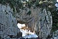
The gate-like Hakusandōmon rock
-
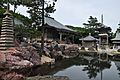
Kongōfuku-ji, the 38th temple on the Shikoku Pilgrimage
-
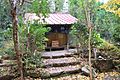
Shinnenan hermitage, a resting spot for pilgrims


See also
 In Spanish: Tosashimizu (Kōchi) para niños
