Town Boundary Markers of Barnstable, Massachusetts facts for kids
Quick facts for kids |
|
|
Town Boundary Marker
|
|
 |
|
| Location | Race Lane, Sandwich and Barnstable, Massachusetts |
|---|---|
| MPS | Barnstable MRA |
| NRHP reference No. | 87000269 |
| Added to NRHP | September 18, 1987 |
Imagine a time long ago, when towns needed clear lines to show where they began and ended! In Barnstable, Massachusetts, there are four special stone markers that did just that. These stones were placed way back in the 1600s, during the early days of the American colonies. They helped mark the edges of Barnstable with its nearby towns.
All four of these old markers are now listed on the National Register of Historic Places. This means they are important historical sites that are protected. Three markers are listed on their own, and one is part of a larger historic area called the Old King's Highway Historic District. Barnstable itself was started in 1639, making these markers very old indeed!
Contents
Historic Town Boundary Stones
These stone markers are like silent witnesses to history. They show us how towns were first laid out and how people kept track of their land centuries ago. Each marker has its own story and unique features.
Race Lane Marker
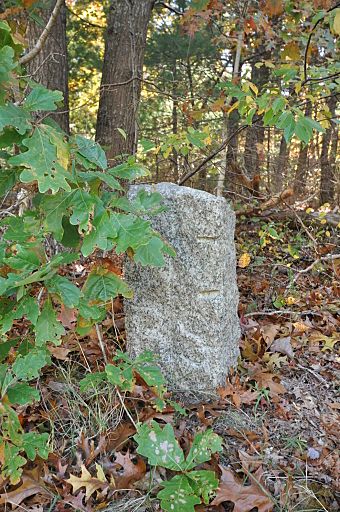
On the south side of Race Lane, you can find a granite stone marking the line between Barnstable and Sandwich. This town line was first drawn by the leaders of the Plymouth Colony in 1639. It has stayed pretty much the same ever since!
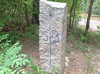
We don't know exactly when this rough stone was put in place. But if you look closely, you'll see a "B" carved on the Barnstable side and an "S" on the Sandwich side. A vertical line separates the two letters. This marker was added to the National Register of Historic Places in 1987.
High Street Marker
|
Town Line Boundary Marker
|
|
 |
|
| Lua error in Module:Location_map at line 420: attempt to index field 'wikibase' (a nil value). | |
| Location | High Street/Old County Rd., Sandwich and Barnstable, Massachusetts |
|---|---|
| Built | 1644 |
| MPS | Barnstable MRA |
| NRHP reference No. | 87000243 |
| Added to NRHP | September 18, 1987 |
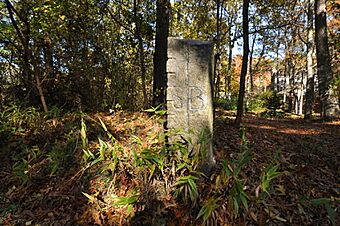
Another important marker is on the north side of High Street, also between Sandwich and Barnstable. It looks a lot like the Race Lane marker, with similar carvings.
This area of West Barnstable was bought from the local Native American tribes in 1644. So, this marker was likely placed sometime after that year. Just like the Race Lane marker, its exact placement date is a mystery. It was also listed on the National Register of Historic Places in 1987.
Great Hill Road Marker
|
Town Line Boundary Marker
|
|
 |
|
| Lua error in Module:Location_map at line 420: attempt to index field 'wikibase' (a nil value). | |
| Location | Great Hill Rd., Barnstable, Massachusetts |
|---|---|
| Area | less than one acre |
| Built | 1644 |
| MPS | Barnstable MRA |
| NRHP reference No. | 87000242 |
| Added to NRHP | September 18, 1987 |
The Great Hill Road marker is another one of these historic stones. In 1987, it was found a short distance north of where Great Hill Road met Cedar Street. Today, these streets no longer connect in the same way.
Like the High Street marker, this stone was probably put in place after 1644, when the land was purchased. It has carvings similar to the other two markers we've talked about. This marker also joined the National Register of Historic Places in 1987.
Main Street Marker
|
Town Boundary Marker
|
|
|
U.S. Historic district
Contributing property |
|
| Location | Main Street (MA 6A), Yarmouth and Barnstable, Massachusetts |
|---|---|
| Area | less than one acre |
| Part of | Old King's Highway Historic District (ID87000314) |
| MPS | Barnstable MRA |
| Added to NRHP | March 12, 1987 |
The fourth special marker is on the north side of Main Street (Massachusetts Route 6A). It marks the boundary between Barnstable and Yarmouth. This marker is different from the others. It's shaped like a large boulder.
On this boulder, you can see "Y+B" carved into the stone, with a wavy line underneath. The "Y" stands for Yarmouth, and the "B" for Barnstable. Experts believe this marker was placed in the 1700s. It's also an important part of the Old King's Highway Historic District.

