Trachselwald District facts for kids
Quick facts for kids
Trachselwald District
Amtsbezirk Trachselwald
|
|
|---|---|
|
District
|
|
 |
|
| Country | |
| Canton | |
| Capital | Trachselwald |
| Area | |
| • Total | 191 km2 (74 sq mi) |
| Population
(2007)
|
|
| • Total | 23,327 |
| • Density | 122.1/km2 (316.3/sq mi) |
| Time zone | UTC+1 (CET) |
| • Summer (DST) | UTC+2 (CEST) |
| Municipalities | 10 |
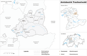
The Trachselwald District was a special area, a bit like a county or region, located in the canton of Bern in Switzerland. It was one of the many districts that helped manage different parts of the canton. The main office for the district's governor was found in Trachselwald Castle, which is in the town of Trachselwald.
What Was Trachselwald District?
A district in Switzerland was a way to organize different towns and villages into a larger group. The Trachselwald District was made up of 10 different towns, which are called municipalities. The total area of this district was about 191 square kilometers. In 2007, around 23,327 people lived in the Trachselwald District.
Towns and Villages
Here are the towns and villages (municipalities) that were part of the Trachselwald District, along with how many people lived there in December 2007 and their size in square kilometers:
| Municipality | Population (Dec 2007) | Area (km²) |
|---|---|---|
| Affoltern im Emmental | 1151 | 11.5 |
| Dürrenroth | 1031 | 14.1 |
| Eriswil | 1431 | 11.3 |
| Huttwil | 4708 | 17.3 |
| Lützelflüh | 4077 | 26.9 |
| Rüegsau | 3051 | 15.1 |
| Sumiswald | 5176 | 59.4 |
| Trachselwald | 1049 | 16.0 |
| Walterswil | 560 | 7.9 |
| Wyssachen | 1193 | 11.8 |
See also
 In Spanish: Distrito de Trachselwald para niños
 | Chris Smalls |
 | Fred Hampton |
 | Ralph Abernathy |

