Trawsgoed facts for kids
Quick facts for kids Trawsgoed |
|
|---|---|
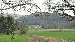
 View of Trawsgoed mansion from the park |
|
| Population | 989 (2011) |
| OS grid reference | SN669731 |
| Principal area | |
| Country | Wales |
| Sovereign state | United Kingdom |
| Post town | Aberystwyth |
| Postcode district | SY23 |
| Police | Dyfed-Powys |
| Fire | Mid and West Wales |
| Ambulance | Welsh |
| EU Parliament | Wales |
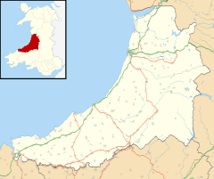
Trawsgoed means "Crosswood" in Welsh. It is a special place in Ceredigion, Wales. Trawsgoed is both a local area, called a community, and a large piece of land with buildings, known as an estate.
The estate is about 8 miles (13 km) southeast of Aberystwyth. The Vaughan family has owned this land for a very long time, since the year 1200. The Vaughans are an old family from North Wales.
The Trawsgoed community had 989 people living there in 2011. It includes the villages of Llanafan and Llanfihangel-y-Creuddyn.
Contents
The Vaughan Family and Trawsgoed Estate
The Trawsgoed estate and its main house became part of the Vaughan family when Adda Fychan married Tudo. She was the daughter of Ifan Goch, who owned Trawsgoed before them.
A very important person for the estate was Sir John Vaughan. He was a lawyer and a member of Parliament. King Charles II made him a top judge. Sir John Vaughan bought a lot of land that used to belong to the Cistercian abbey of Strata Florida. He also gained more land when he married Jane Stedman.
The Vaughan family has kept Trawsgoed for over 800 years. It has been passed down from father to son. This is very rare for families who have owned a house since the Middle Ages.
In the 1500s, Trawsgoed became a large estate like those in England. During the English Reformation, the Strata Florida Abbey lands were sold. Most of these lands were bought by the Stedman family. Sir John Vaughan married into the Stedman family, bringing almost all the abbey land to the Vaughans.
In 1695, John Vaughan, a grandson of Sir John Vaughan, was given the title Viscount Lisburne. Later, in 1776, the family was given the title Earl of Lisburne. They continued to live at Trawsgoed mansion for many generations.
In 1947, the main house became an office for the Ministry of Agriculture. Today, the farm part of the estate is used by scientists for research.
Exploring the Trawsgoed Grounds
In 1873, the Trawsgoed estate was the biggest in Cardiganshire. It covered about 42,666 acres (173 square kilometers). The Vaughan family has worshipped at St Afan's Church for many years. This church is located right on the estate.
The beautiful gardens and park around the house are very important. They are listed as Grade II on the Welsh historic parks register. This means they are special and protected. From 2006 to 2008, the estate was even used for a special stage in the British Rally car race.
Trawsgoed Mansion: A Grand House
Trawsgoed Mansion is a large country house built in the 1600s. It is also known as Crosswood Park. This house used to be the home of the Earl of Lisburne. It is a Grade II* listed building, meaning it is very important historically.
The 6th Earl of Lisburne added a big new part to the house. This Victorian section had 50 rooms. He also built a summerhouse, squash and tennis courts, and a fancy fountain. The house eventually had 70 rooms. Its gardens grew rare trees from places like Chile and the Himalayas. These trees liked the mild, wet weather of coastal Wales. The house also has great views of the Cambrian Mountains. There are even remains of a small Roman fort nearby.
The mansion was sold in 2007 to the Edwards family. They spent five years making the house look new again. Their work was shown on a TV show called The Restoration Man in 2010. The house was put up for sale again in 2012.
The Vaughan family still owns over 5,000 acres (20 square kilometers) of the original estate. This land includes pastures, farmland, and common land. They also let people use the land for shooting and fishing in the River Ystwyth and Teifi.
The last Vaughan family member to live in the house was John Edward Malet Vaughan. He was born in 1952. He now manages the Trawsgoed Estates company.
Lisburne Mines: A Rich History
The Trawsgoed estate was also home to the Lisburne (Lead) Mines. These were some of the most profitable mines in all of Wales. In the 1880s, Trawsgoed had the second largest lead mine in Britain. The estate still owns the rights to the minerals under this land.
Nearby Estates
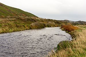
The Trawsgoed estate shares a border with the Hafod estate and Nanteos. This border runs along the River Ystwyth.
Trawsgoed Weather
The Met Office has a weather station at Trawsgoed. This station collects information about the local weather. Trawsgoed has an oceanic climate, which means it has mild temperatures and rain all year round.
Temperatures can range from hot summers to cold winters. For example, it was 32.7°C (90.9°F) in July 2006. It dropped to -13.8°C (7.2°F) in January 2010. On average, there are about 48 nights a year with frost. It rains on about 169 days each year. Trawsgoed holds the record for the UK's hottest November day, which was 22.4°C (72.3°F) on November 1, 2015.
| Climate data for Trawsgoed, elevation 63m, 1971-2000 | |||||||||||||
|---|---|---|---|---|---|---|---|---|---|---|---|---|---|
| Month | Jan | Feb | Mar | Apr | May | Jun | Jul | Aug | Sep | Oct | Nov | Dec | Year |
| Mean daily maximum °C (°F) | 8.0 (46.4) |
7.9 (46.2) |
9.8 (49.6) |
12.2 (54.0) |
15.7 (60.3) |
17.7 (63.9) |
19.8 (67.6) |
19.5 (67.1) |
17.5 (63.5) |
14.2 (57.6) |
10.6 (51.1) |
8.9 (48.0) |
13.5 (56.3) |
| Mean daily minimum °C (°F) | 2.0 (35.6) |
2.0 (35.6) |
2.8 (37.0) |
3.4 (38.1) |
6.2 (43.2) |
8.5 (47.3) |
11.4 (52.5) |
11.0 (51.8) |
9.2 (48.6) |
7.1 (44.8) |
4.2 (39.6) |
2.9 (37.2) |
5.9 (42.6) |
| Average precipitation mm (inches) | 126.4 (4.98) |
92.2 (3.63) |
99.0 (3.90) |
70.7 (2.78) |
66.0 (2.60) |
78.5 (3.09) |
72.3 (2.85) |
91.2 (3.59) |
104.0 (4.09) |
133.8 (5.27) |
140.1 (5.52) |
139.7 (5.50) |
1,213.9 (47.8) |
| Source: MetOffice | |||||||||||||
| Climate data for Trawsgoed, elevation 63m, 1981-2010 | |||||||||||||
|---|---|---|---|---|---|---|---|---|---|---|---|---|---|
| Month | Jan | Feb | Mar | Apr | May | Jun | Jul | Aug | Sep | Oct | Nov | Dec | Year |
| Mean daily maximum °C (°F) | 8.2 (46.8) |
8.3 (46.9) |
10.2 (50.4) |
12.8 (55.0) |
15.9 (60.6) |
18.1 (64.6) |
19.8 (67.6) |
19.6 (67.3) |
17.7 (63.9) |
14.4 (57.9) |
10.9 (51.6) |
8.6 (47.5) |
13.7 (56.7) |
| Mean daily minimum °C (°F) | 2.0 (35.6) |
1.7 (35.1) |
3.0 (37.4) |
3.9 (39.0) |
6.7 (44.1) |
9.2 (48.6) |
11.6 (52.9) |
11.3 (52.3) |
9.4 (48.9) |
7.3 (45.1) |
4.3 (39.7) |
2.2 (36.0) |
6.1 (43.0) |
| Average rainfall mm (inches) | 121.7 (4.79) |
86.9 (3.42) |
97.7 (3.85) |
72.7 (2.86) |
69.5 (2.74) |
76.4 (3.01) |
84.0 (3.31) |
86.5 (3.41) |
100.0 (3.94) |
145.2 (5.72) |
141.2 (5.56) |
135.0 (5.31) |
1,216.7 (47.90) |
| Average rainy days (≥ 1.0 mm) | 17.0 | 12.8 | 15.3 | 12.6 | 11.8 | 11.6 | 12.3 | 13.4 | 13.3 | 16.6 | 17.6 | 16.7 | 170.9 |
| Mean monthly sunshine hours | 45.5 | 69.7 | 89.1 | 159.8 | 191.0 | 178.4 | 176.6 | 180.6 | 132.3 | 96.8 | 57.8 | 39.5 | 1,417.1 |
| Source: metoffice.gov.uk | |||||||||||||
 | Tommie Smith |
 | Simone Manuel |
 | Shani Davis |
 | Simone Biles |
 | Alice Coachman |


