
Trout River (Florida) facts for kids
Quick facts for kids Trout River |
|
|---|---|
| Country | United States |
| Physical characteristics | |
| Main source | Northwestern Duval County, Florida |
| River mouth | St. Johns River at Sandfly Point. |
| Length | 20 miles (32 km) |
The Trout River is a 20-mile (about 32 km) long river in Duval County, Florida. It flows into the larger St. Johns River. This river is entirely located within the city of Jacksonville, in an area called the Northside. Near where it meets the St. Johns River, the water in the Trout River is a bit salty. This is called brackish water.
The widest part of the Trout River is close to the St. Johns River. Here, it stretches about 0.6 miles (1 km) across. The river also has many wet, marshy areas called wetlands. These wetlands reach all the way to the mouth of its longest side-stream, the Ribault River.
Contents
What Rivers Flow Into the Trout River?
The Trout River has several smaller rivers and creeks that flow into it. These are called tributaries. The main tributaries of the Trout River are the Ribault River, Little Trout River, and Moncrief Creek.
Where Does the Trout River Flow?

The Trout River starts in the northwestern part of Jacksonville. At its very beginning, it's just a small stream or creek.
Just a short distance from where it starts, the river goes under U.S. Route 1. A little further downstream, it flows through a neighborhood called River Falls. After this, the river gets wider and turns into wetlands. Many smaller streams join it here.
About 2.3 miles (3.7 km) downstream, a long tributary called the "Little Trout River" joins in. This smaller river begins in a forest near U.S. Route 1 and Interstate 295.
Further along, State Road 115 crosses the Trout River. This crossing is known as the C Ray Greene Bridge. After about 2.2 miles (3.5 km) from there, the river's water starts to become brackish, meaning it's a mix of fresh and salt water.
The Ribault River is another important tributary. It's the longest of the three main streams that flow into the Trout River. A short distance after the Ribault River joins, Interstate 95 crosses the Trout River on the Trout River Bridge.
The last major tributary to join the Trout River is Moncrief Creek. Finally, about 0.7 miles (1.1 km) downstream from Moncrief Creek, U.S. Route 17 crosses the river. About 1 mile (1.6 km) after that, the Trout River reaches its end. It flows into the St. Johns River at a spot called Sandfly Point.
Bridges Over the Trout River
Many roads and bridges cross over the Trout River as it flows through Jacksonville. Here are some of the main crossings:
- U.S. Route 17
- Kingsland Subdivision (a railroad line)
- Interstate 95 (on the Trout River Bridge)
- State Road 115 (on the C. Ray Greene Bridge)
- Interstate 295
- U.S. Route 1 and U.S. Route 23
Places Along the Trout River
There are several interesting places located along the Trout River:
- Jacksonville Zoo: A popular zoo where you can see many animals.
- Trout River Boulevard: A road that runs next to the river for about 3.9 miles (6.3 km). It's a residential road, meaning people live along it.
- Navy Fuel Depot: A facility used by the Navy.
Parks by the River
You can also find some parks along the Trout River where people can enjoy nature:
- North Shore Park: This is a park with lots of trees. It's located at the north end of Pearl Street in the North Shore neighborhood of Jacksonville. It covers about 0.3 square miles (0.78 km2).
- Riverside Park: This park has two docks, which are platforms built out over the water.
Images for kids
-
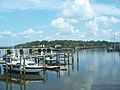
Trout River near US 17
-
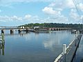
Trout River near US 17


