
Tucurú facts for kids
Quick facts for kids
Tucurú
San Miguel Tucurú
|
|
|---|---|
|
Municipality
|
|

Tucurú
Location in Alta Verapaz Department

Tucurú
Location in Guatemala
|
|
| Country | |
| Department | |
| Area | |
| • Municipality | 219 km2 (85 sq mi) |
| Elevation | 477 m (1,565 ft) |
| Population
(2018 census)
|
|
| • Municipality | 43,473 |
| • Density | 198.5/km2 (514.1/sq mi) |
| • Urban | 4,064 |
| Time zone | GMT -6 |
| Climate | Af |
Tucurú is a small town and a municipality in Guatemala. A municipality is like a local government area. It is located in the Alta Verapaz department, which is similar to a state or province. In 2018, about 43,473 people lived in the Tucurú municipality.
Contents
History of Tucurú
The Verapaz Railroad
The Verapaz Railroad started on January 15, 1894. It was built because of an agreement, called a contract, between the government of Guatemala and a company. At that time, José María Reina Barrios was the president of Guatemala. The contract said that a 30-mile long railroad line would be built and kept up between the towns of Panzós and Pancajché.
Trains for passengers ran twice a week, on Mondays and Thursdays. Mail also arrived by ship every Wednesday. Cargo, like goods and products, came from Livingston, Izabal. The train also made stops in Santa Rosita, Santa Catalina La Tinta, and Papalhá.
By 1898, the railroad was doing very well. This was because coffee farming was growing in Cobán, which was the third largest city in Guatemala back then. People planned to extend the railroad all the way to Cobán. The railroad kept running until 1965. After that, trucks and new highways became more common, so the trains were no longer needed.
The Thomae Family and Their Farms
The Thomae family was one of the most important German families who came to this region in the late 1800s. They had their main base in the nearby town of Purulhá. Mauricio Thomae owned many farms, called haciendas, in the area. Here are some of his early haciendas:
| Year | Farm Name | Location |
|---|---|---|
| 1882 | Cubilgüitz | Cobán |
| 1889 | San Isidro | Purulhá |
| 1897 | Comija | Tamahú |
| 1897 | Popabaj | Tucurú |
| 1900 | Nueve Aguas | Purulhá |
| 1902 | Panzal | Purulhá |
| 1902 | Rocjá | Tamahú |
| 1902 | Paijá | Tucurú |
| 1905 | Chimox | Tucurú |
Later, when Jorge Ubico was president of Guatemala (from 1931 to 1944), Mauricio Thomae became one of the most powerful landowners in the German Verapaz area. Other important families included the Sarg, Sapper, and Diesseldorf families. President Ubico had been the governor of Cobán before he became president. A governor is a leader of a region. During his time as governor, he became friends with several German families, including the Thomaes.
Climate
Tucurú has a tropical rainforest climate. This means it is warm all year round and gets a lot of rain. It's like living in a jungle!
| Climate data for Tucurú | |||||||||||||
|---|---|---|---|---|---|---|---|---|---|---|---|---|---|
| Month | Jan | Feb | Mar | Apr | May | Jun | Jul | Aug | Sep | Oct | Nov | Dec | Year |
| Mean daily maximum °C (°F) | 27.8 (82.0) |
29.7 (85.5) |
30.9 (87.6) |
32.4 (90.3) |
32.0 (89.6) |
31.1 (88.0) |
30.1 (86.2) |
30.7 (87.3) |
30.6 (87.1) |
29.6 (85.3) |
28.5 (83.3) |
27.9 (82.2) |
30.1 (86.2) |
| Daily mean °C (°F) | 22.6 (72.7) |
23.8 (74.8) |
25.0 (77.0) |
26.4 (79.5) |
26.5 (79.7) |
26.1 (79.0) |
25.5 (77.9) |
25.8 (78.4) |
25.8 (78.4) |
25.0 (77.0) |
23.8 (74.8) |
23.0 (73.4) |
24.9 (76.9) |
| Mean daily minimum °C (°F) | 17.5 (63.5) |
18.0 (64.4) |
19.2 (66.6) |
20.5 (68.9) |
21.0 (69.8) |
21.1 (70.0) |
21.0 (69.8) |
20.9 (69.6) |
21.0 (69.8) |
20.4 (68.7) |
19.1 (66.4) |
18.2 (64.8) |
19.8 (67.7) |
| Average precipitation mm (inches) | 88 (3.5) |
62 (2.4) |
64 (2.5) |
96 (3.8) |
185 (7.3) |
373 (14.7) |
397 (15.6) |
307 (12.1) |
385 (15.2) |
394 (15.5) |
159 (6.3) |
92 (3.6) |
2,602 (102.5) |
| Source: Climate-Data.org | |||||||||||||
Geographic Location
Tucurú is located in a central spot, surrounded by several other towns and municipalities:
 |
San Juan Chamelco and Senahú, both in the Alta Verapaz department | |
||
| Tamahú, also in the Alta Verapaz department | Santa Catalina La Tinta, in the Alta Verapaz department | |||
| Purulhá, in the Baja Verapaz Department |
Images for kids
-
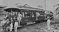
The Verapaz Railroad's very first trip in 1894.
-
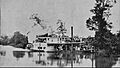
A steamboat from the Verapaz Railroad sailing on the Polochic river.
-
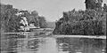
Coffee being transported by boat.
-
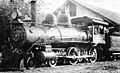
A Verapaz Railroad engine in the early 1900s.


See also
 In Spanish: Tucurú para niños
