
Purulhá facts for kids
Quick facts for kids
Purulhá
|
|
|---|---|
|
Municipality
|
|

Purulhá
Location in Guatemala
|
|
| Country | |
| Department | |
| Area | |
| • Municipality | 536 km2 (207 sq mi) |
| Population | |
| • Municipality | 56,822 |
| • Density | 106.01/km2 (274.57/sq mi) |
| • Urban | 7,901 |
| Climate | Cfb |
Purulhá is a town and a municipality in the Baja Verapaz department of Guatemala. It is located high up, about 1,570 meters (5,151 feet) above sea level. The municipality covers an area of 536 square kilometers. In 2018, about 56,822 people lived there. Purulhá has a special festival every year from June 10 to June 13.
Contents
History of Purulhá
The Verapaz Railroad
The Verapaz Railroad started on January 15, 1894. This was after an agreement was made between Guatemala and a company called "Verapaz Railroad & Northern Agency Ltd." The agreement was for 99 years. It set the rules for building and keeping a 30-mile long railroad line. This line connected the towns of Panzós and Pancajché.
Trains for people ran twice a week, on Mondays and Thursdays. Mail also arrived by ship every Wednesday. Cargo, like goods and products, came from Livingston, Izabal. The train also stopped at places like Santa Rosita, Santa Catalina La Tinta, and Papalhá.
By 1898, the railroad was doing very well. This was because of the growing coffee business in Cobán. Cobán was the third-largest city in Guatemala at that time. So, there were plans to make the railroad longer, all the way to Cobán. The railroad was used until 1965. After that, trucks and new roads took over for transport.
The Thomae Family's Influence
The Thomae family came from German settlers who arrived in the 1880s. They were a very powerful family in Purulhá for most of the 1900s. They became very successful because of policies that favored German people. Mauricio Thomae, a member of the family, bought many coffee farms, called haciendas.
| Year | Hacienda | Location |
|---|---|---|
| 1882 | Cubilgüitz | Cobán |
| 1889 | San Isidro | Purulhá |
| 1897 | Comija | Tamahú |
| 1897 | Popabaj | Tucurú |
| 1900 | Nueve Aguas | Purulhá |
| 1902 | Panzal | Purulhá |
| 1902 | Rocjá | Tamahú |
| 1902 | Paijá | Tucurú |
| 1905 | Chimox | Tucurú |
During the time of President Jorge Ubico (1931-1944), Mauricio Thomae became one of the most important German landowners in the Verapaz region. He was friends with President Ubico, who had been a governor in Cobán earlier. This friendship helped the Thomae family.
For most of the 20th century, the Thomae family controlled Purulhá. This was because they owned huge coffee plantations and farmland. They kept their land even when many other Germans were asked to leave Guatemala during World War II.
After a problem with coffee prices in 2000, the Thomae family started investing in other things. They put money into power generation, tourism, and forest projects. By 2015, they were planning a big power project called Enerjá. This project would connect to another power plant they owned, El Cafetal.
Climate
Purulhá has a temperate climate. This means it has mild temperatures, not too hot and not too cold. It is classified as Cfb in the Köppen climate classification system.
| Climate data for Purulhá | |||||||||||||
|---|---|---|---|---|---|---|---|---|---|---|---|---|---|
| Month | Jan | Feb | Mar | Apr | May | Jun | Jul | Aug | Sep | Oct | Nov | Dec | Year |
| Mean daily maximum °C (°F) | 18.8 (65.8) |
20.2 (68.4) |
21.7 (71.1) |
22.4 (72.3) |
22.8 (73.0) |
22.2 (72.0) |
21.5 (70.7) |
21.8 (71.2) |
22.0 (71.6) |
21.1 (70.0) |
20.3 (68.5) |
19.7 (67.5) |
21.2 (70.2) |
| Daily mean °C (°F) | 14.6 (58.3) |
15.4 (59.7) |
16.7 (62.1) |
17.5 (63.5) |
18.2 (64.8) |
18.2 (64.8) |
17.8 (64.0) |
17.8 (64.0) |
17.9 (64.2) |
17.3 (63.1) |
16.2 (61.2) |
15.3 (59.5) |
16.9 (62.4) |
| Mean daily minimum °C (°F) | 10.4 (50.7) |
10.7 (51.3) |
11.8 (53.2) |
12.6 (54.7) |
13.6 (56.5) |
14.3 (57.7) |
14.1 (57.4) |
13.9 (57.0) |
13.9 (57.0) |
13.5 (56.3) |
12.1 (53.8) |
10.9 (51.6) |
12.7 (54.8) |
| Average precipitation mm (inches) | 81 (3.2) |
48 (1.9) |
68 (2.7) |
68 (2.7) |
174 (6.9) |
325 (12.8) |
329 (13.0) |
245 (9.6) |
272 (10.7) |
205 (8.1) |
125 (4.9) |
66 (2.6) |
2,006 (79.1) |
| Source: Climate-Data.org | |||||||||||||
Geographic Location
 |
Tactic, in the Alta Verapaz Department | Tactic, Tamahú and Tucurú, all in the Alta Verapaz Department | Santa Catalina La Tinta, in the Alta Verapaz Department | |
| Santa Catalina La Tinta, in the Alta Verapaz Department | ||||
| Salamá, in the Baja Verapaz Department |
Images for kids
-
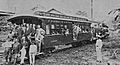
The first trip of the Verapaz Railroad in 1894.
-
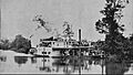
A steamboat from the Verapaz Railroad sailing on the Polochic river.
-
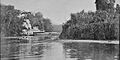
Coffee being transported.
-
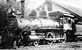
A Verapaz Railroad engine in the early 1900s.


See also
 In Spanish: Purulhá para niños
