
Santa Catalina la Tinta facts for kids
Quick facts for kids
Santa Catalina la Tinta
La Tinta
|
||
|---|---|---|
|
Municipality
|
||

Central park of Santa Catalina la Tinta
|
||
|
||

Santa Catalina la Tinta
Location in Alta Verapaz Department

Santa Catalina la Tinta
Location in Guatemala
|
||
| Country | ||
| Region | Corredor Seco | |
| Department | ||
| Municipality | Santa Catalina la Tinta | |
| Government | ||
| • Type | Municipal | |
| Area | ||
| • Municipality | 250 km2 (100 sq mi) | |
| Elevation | 195 m (640 ft) | |
| Population
(Census 2018)
|
||
| • Municipality | 40,516 | |
| • Density | 162/km2 (420/sq mi) | |
| • Urban | 20,552 | |
| • Ethnicities | Q'eqchi' Poqomchi' Ladino | |
| • Religions | Roman Catholicism Evangelicalism Maya | |
| Time zone | UTC-6 (Guatemala) | |
| Climate | Am | |
| Patron Saint | Saint Catherine of Alexandria (November 24–28) | |

Santa Catalina la Tinta is a town and municipality in the Guatemalan area called Alta Verapaz. It is found in the warm Polochic River valley. This town used to be part of another municipality called Panzós. But in 1999, it became its own separate municipality.
La Tinta is a busy place for buying and selling things in the lower Polochic valley. Merchants and shoppers fill the streets, especially on market days, which are Tuesdays and Thursdays. The town of Santa Catalina la Tinta is about 110 kilometers (68 miles) from Cobán and 278 kilometers (173 miles) from Guatemala City. In 2018, its population was 20,552 people.
Contents
The History of La Tinta
The town of La Tinta was started on August 14, 1896. It was founded by a German immigrant named Erwin Pablo Dieseldorf. He lived in Cobán, Alta Verapaz, and owned the land where the town now stands. Dieseldorf gave a large piece of this land to his workers. This land was officially recorded as a farm.
Long ago, La Tinta was an important place for leaders and religious groups. In the 1500s, a group of friars (religious brothers) called the Order of Preachers set up their main center here. However, after Central America became independent, these religious groups were asked to leave. Their properties were taken by the Guatemalan government.
The Verapaz Railroad
In the late 1800s, growing coffee became very popular. Because of this, a railroad called the Verapaz Railroad was built in the 1890s. This made the river port of Panzós very important for trade. The main offices for the area were moved from La Tinta to Panzós. From then on, the people of La Tinta wanted their town to be separate from Panzós.
The Verapaz Railroad started on January 15, 1894. It was a 99-year agreement between Guatemala and a company called "Verapaz Railroad & Northern Agency Ltd." The railroad line was about 30 miles long, connecting Panzós and Pancajché. Trains ran twice a week for passengers, on Mondays and Thursdays. Mail arrived by ship every Wednesday, and cargo came from Livingston, Izabal. The train also stopped in Santa Rosita, Santa Catalina La Tinta, and Papalhá.
By 1898, coffee was doing so well in Cobán (which was Guatemala's third-largest city then) that there were plans to extend the railroad to Cobán. The railroad worked until 1965. After that, trucks and highways took over, and the railroad was no longer needed.
-
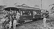
The first trip of the Verapaz Railroad in 1894.
-
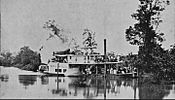
A steamboat from the Verapaz Railroad on the Polochic river.
-
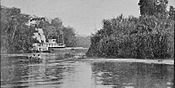
Transporting coffee by river.
-
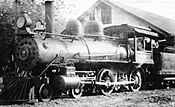
A Verapaz Railroad engine in the early 1900s.


Becoming Its Own Municipality
In the 1980s, a group of people tried to make La Tinta its own municipality. But they faced many problems and had to stop. A new group formed in 1987. It wasn't until 1999 that this group, led by José Gilberto Artola Choc, finally succeeded.
They argued that La Tinta should be separate from Panzós because of the distance (about 30 kilometers or 19 miles). Also, La Tinta's economy was growing, while Panzós had declined after the railroad stopped in the 1960s. La Tinta also had enough people to become its own municipality.
On November 11, 1999, La Tinta officially became the sixteenth municipality in the Alta Verapaz Department. This was made possible by a special law from the Congress.
The Municipality Seal
On August 14, 1996, La Tinta celebrated its 100th birthday. At that time, it was still part of Panzós. Professor Jorge Zoel Tercero was in charge of the celebrations. He designed the official Seal of La Tinta. He placed a copy of the seal in a special book for the town.
The seal was shown to everyone during the Centennial celebrations. Important people like the governor of Alta Verapaz Department and the mayor of Panzós were there. Besides the seal, Professor Tercero also wrote a detailed description of La Tinta. When La Tinta became its own municipality, this seal was made official by the town's first leaders.
Climate in Santa Catalina La Tinta
Santa Catalina La Tinta has a tropical monsoon climate. This means it is generally hot all year with a very rainy season.
| Climate data for Santa Catalina La Tinta | |||||||||||||
|---|---|---|---|---|---|---|---|---|---|---|---|---|---|
| Month | Jan | Feb | Mar | Apr | May | Jun | Jul | Aug | Sep | Oct | Nov | Dec | Year |
| Mean daily maximum °C (°F) | 30.7 (87.3) |
32.4 (90.3) |
34.1 (93.4) |
35.2 (95.4) |
34.7 (94.5) |
34.0 (93.2) |
33.2 (91.8) |
33.6 (92.5) |
33.4 (92.1) |
32.6 (90.7) |
31.3 (88.3) |
30.5 (86.9) |
33.0 (91.4) |
| Daily mean °C (°F) | 26.0 (78.8) |
26.8 (80.2) |
28.3 (82.9) |
29.3 (84.7) |
29.3 (84.7) |
28.9 (84.0) |
28.5 (83.3) |
28.7 (83.7) |
28.6 (83.5) |
28.0 (82.4) |
26.9 (80.4) |
26.0 (78.8) |
27.9 (82.3) |
| Mean daily minimum °C (°F) | 21.3 (70.3) |
21.3 (70.3) |
22.6 (72.7) |
23.5 (74.3) |
24.0 (75.2) |
23.9 (75.0) |
23.9 (75.0) |
23.8 (74.8) |
23.8 (74.8) |
23.5 (74.3) |
22.5 (72.5) |
21.6 (70.9) |
23.0 (73.3) |
| Average precipitation mm (inches) | 55 (2.2) |
44 (1.7) |
47 (1.9) |
91 (3.6) |
175 (6.9) |
382 (15.0) |
487 (19.2) |
388 (15.3) |
362 (14.3) |
234 (9.2) |
123 (4.8) |
60 (2.4) |
2,448 (96.5) |
| Source: Climate-Data.org | |||||||||||||
Where is Santa Catalina La Tinta Located?
The municipality of Santa Catalina La Tinta has borders with several other places:
 |
Senahú, a municipality in Alta Verapaz Department | |
||
| Purulhá, a municipality in Baja Verapaz Department | Panzós, a municipality in Alta Verapaz Department | |||
| Teculután, a municipality in Zacapa Department |
Distances to Other Places
Here are the distances from Santa Catalina La Tinta to some other important places:
- To Cobán, the capital of Alta Verapaz Department: 93 kilometers (58 miles)
- To Guatemala City, the capital of Guatemala: 245 kilometers (152 miles)
- To the municipality of Tucurú: 32 kilometers (20 miles)
- To the municipality of Tamahú: 48 kilometers (30 miles)
- To the municipality of Tactic: 60 kilometers (37 miles)
- To Telemán, a settlement in the municipality of Panzós: 15 kilometers (9 miles)
- To the municipality of Senahú: 40 kilometers (25 miles)
- To the municipality of Panzós: 30 kilometers (19 miles)
- To the municipality of El Estor, Izabal: 85 kilometers (53 miles)
See also
 In Spanish: La Tinta (Alta Verapaz) para niños
