
Panzós facts for kids
Quick facts for kids
Panzós
|
|
|---|---|
|
Municipality of Guatemala
|
|

Port of Panzos in the 1900s
|
|

Panzós
Location in Alta Verapaz Department

Panzós
Location in Guatemala
|
|
| Country | |
| Department | |
| Area | |
| • Total | 354 sq mi (917 km2) |
| Population
(2018 census)
|
|
| • Total | 71,846 |
| • Density | 202.92/sq mi (78.35/km2) |
| Climate | Am |
Panzós is a town and a municipality in the Alta Verapaz region of Guatemala. In 2018, about 22,068 people lived in the town. The name Panzós means "place of the green waters." This name comes from the nearby Polochic River and its green swamps, which are home to alligators and many birds. Panzós is also known for a sad event that happened on May 29, 1978, when many local people died during a protest.
Contents
Panzós: A Look at Its Past
The area around the Polochic River was first home to the Q'eqchi' and Poqomchi' peoples. The first Spanish settlement in Panzós was likely founded in the mid-1800s. By 1891, Panzós officially became part of the Alta Verapaz Department.
Land and Farming in Panzós
After a big change in government in 1871, the president at the time, Justo Rufino Barrios, started giving land to German settlers. A special law made it easier for the government to take land that had been protected for Indigenous people. This land was then given to German settlers and military officers.
Since then, the main crops grown in the area have been coffee, cardamom, and bananas. During those years, a few people owned most of the land. Many local people worked on these large farms, often under difficult conditions.
Panzós as a Trading Hub
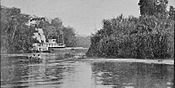
In the 1880s, Panzós became a very important river port for trade. Coffee grown in the region was brought to Panzós using oxen carts or small boats. From Panzós, the coffee was loaded onto bigger ships. These ships then sailed to the Caribbean Sea and on to places like Europe. This way of moving goods changed a lot when the Verapaz Railroad was built in the 1890s.
Building the Verapaz Railroad
The Verapaz Railroad started being built on January 15, 1894. A company called Verapaz Railroad & Northern Agency Ltd. signed a 99-year agreement with the government of Guatemala. This agreement was for building and running a 30-mile railroad line. It connected Panzós to Pancajché.
Trains for passengers ran twice a week. Mail arrived by ship every Wednesday. Cargo, like coffee, came from Livingston, Izabal. The train also stopped at places like Santa Rosita, Santa Catalina La Tinta, and Papalhá.
By 1898, the railroad was doing very well because of the growing coffee trade in Cobán. Cobán was the third largest city in Guatemala at the time. The railroad was planned to be extended to Cobán. The Verapaz Railroad continued to operate until 1965. After that, trucks and highways became the main way to transport goods.
-
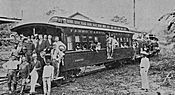
Verapaz Railroad maiden voyage in 1894.
-
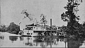
Verapaz Railroad steamboat sailing the Polochic river.
-
Coffee transport.
-
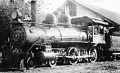
Verapaz Railroad engine in the 1900s.


The Northern Transversal Strip and the Panzós Incident
Lua error in Module:Location_map at line 420: attempt to index field 'wikibase' (a nil value). The Northern Transversal Strip was an area created in 1970 for farming. It included many towns in different regions of Guatemala, including some in Alta Verapaz.
On May 27, 1978, a sad event happened near Panzós. Local farmers from San Vicente were working their land near the Polochic river. People connected to a local landlord arrived with armed soldiers. They tried to stop the farmers from asking for their land rights. That same day, two farmers were held by the military, and others were treated roughly. One farmer was killed during a small conflict.
On May 28, farmers from La Soledad and Cahaboncito asked the mayor of Panzós to help them with their land problems. They wanted him to speak up for them.
On May 29, 1978, many farmers, including men, women, and children, gathered in downtown Panzós. They came from several nearby villages. They brought their farm tools, but they did not have weapons. Their goal was to protest for their land rights and against unfair treatment. One person who was there later said they only wanted to understand the land situation. During this gathering, a tragic event occurred. Many people died from gunfire. This event is remembered as the Panzós massacre.
Panzós Climate
Panzós has a tropical monsoon climate. This means it has a long rainy season and a shorter dry season. The weather is generally warm and humid throughout the year.
| Climate data for Panzós | |||||||||||||
|---|---|---|---|---|---|---|---|---|---|---|---|---|---|
| Month | Jan | Feb | Mar | Apr | May | Jun | Jul | Aug | Sep | Oct | Nov | Dec | Year |
| Mean daily maximum °C (°F) | 30.4 (86.7) |
32.0 (89.6) |
33.6 (92.5) |
34.8 (94.6) |
34.6 (94.3) |
34.1 (93.4) |
33.2 (91.8) |
33.2 (91.8) |
33.2 (91.8) |
32.4 (90.3) |
31.0 (87.8) |
30.3 (86.5) |
32.7 (90.9) |
| Daily mean °C (°F) | 26.0 (78.8) |
26.7 (80.1) |
28.1 (82.6) |
29.1 (84.4) |
29.4 (84.9) |
29.2 (84.6) |
28.8 (83.8) |
28.7 (83.7) |
28.5 (83.3) |
28.0 (82.4) |
26.8 (80.2) |
26.0 (78.8) |
27.9 (82.3) |
| Mean daily minimum °C (°F) | 21.7 (71.1) |
21.4 (70.5) |
22.6 (72.7) |
23.5 (74.3) |
24.3 (75.7) |
24.3 (75.7) |
24.4 (75.9) |
24.0 (75.2) |
23.8 (74.8) |
23.6 (74.5) |
22.6 (72.7) |
21.8 (71.2) |
23.2 (73.7) |
| Average precipitation mm (inches) | 85 (3.3) |
54 (2.1) |
66 (2.6) |
70 (2.8) |
216 (8.5) |
503 (19.8) |
525 (20.7) |
381 (15.0) |
380 (15.0) |
244 (9.6) |
124 (4.9) |
101 (4.0) |
2,749 (108.3) |
| Source: Climate-Data.org | |||||||||||||
Where is Panzós Located?
Panzós is located in a central part of Guatemala. It shares borders with several other municipalities and departments:
 |
Senahú and Cahabón, municipalities of Alta Verapaz Department | |
||
| Tucurú, Santa Catalina La Tinta and Purulhá, municipalities of Baja Verapaz Department | El Estor, municipality of Izabal Department | |||
| Teculután and Río Hondo, municipalities of Zacapa Department |
See also
 In Spanish: Panzós para niños
