Tulcán facts for kids
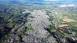
Tulcán is a city in Ecuador and the capital of the Carchi Province. In 2022, about 56,719 people lived there. Tulcán is famous for its amazing topiary garden cemetery, which has plants shaped into incredible designs. This cemetery was created by José Maria Azael Franco in 1936 using Cupressus sempervirens trees.
The city is the highest in Ecuador, sitting about 2,980 meters (9,777 feet) above sea level. It is located in the northern part of the Andes Mountains and is only about 7 kilometers (4.3 miles) from the border with Colombia.
Quick facts for kids
Tulcán
|
||
|---|---|---|
|
City
|
||

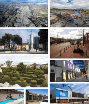
From top, left to right: Aerial view of the city, south of Tulcan, Central Park of Independence, University Avenue, José María Azael Franco Guerrero Cemetery, Lemarie Theater, City of Tulcán Velodrome, Carchi State Polytechnic University and Eloy Alfaro Market.
|
||
|
||
| Nickname(s):
"Heir of the Sun, and Earth"
|
||
| Country | ||
| Province | Carchi | |
| Canton | Tulcán Canton | |
| Area | ||
| • City | 11.09 km2 (4.28 sq mi) | |
| Elevation | 2,980 m (9,780 ft) | |
| Population
(2022 census)
|
||
| • City | 56,719 | |
| • Density | 5,114.4/km2 (13,246/sq mi) | |
| Demonym(s) | Tulcaneño,-a | |
| Time zone | UTC−5 | |
| Postal code |
EC040101-2
|
|
| Area code(s) | (+593) 6 | |
| Climate | Csb | |
Contents
What's in a Name? The Meaning of Tulcán
The name Tulcán comes from an old local word, Hul-Can, which means "Warrior". The Spanish later changed it to Tulcán.
A Look Back: Tulcán's History
The first people known to live in this area were the Quillasingas. The Incas tried to conquer this land, but they didn't fully succeed. The northernmost point of the Inca Empire was said to be the Rumichaca Bridge, which is about 7 kilometers (4.3 miles) from Tulcán. Today, this bridge marks the border between Ecuador and Colombia.
When the Spanish arrived, they were looking for gold. They called the local people "Gold Noses" (Quillasingas). The Spanish officially founded Tulcán on June 11, 1535. The city grew and became an important place in the region during the time of Spanish rule.
Fighting for Freedom: Tulcán's Independence
Many people in the region wanted to be free from Spanish rule. In Carchi, leaders like Alejandro Ruano and others fought for independence. Sadly, on April 14, 1814, some of these brave leaders were shot for their efforts. But the people kept fighting. In 1820, they supported the Declaration of Independence. When Ecuador became its own country, Tulcán remained important because it was a border town.
Close to the Border: Tulcán and Colombia
Tulcán is very close to the Colombian border, only about 2 kilometers (1.2 miles) away. The Rumichaca Bridge, which crosses the Carchi River, connects the two countries. Tulcán is bordered by the city of Ipiales in Colombia to the north. To the south, it borders the San Pedro de Huaca Canton. To the east, it's near the Amazon Rainforest provinces, and to the west, it's close to the coastal province of Esmeraldas.
Because it's so close to Colombia, Tulcán and Ipiales together form a large area with about 150,000 people. This closeness means Tulcán has a strong connection with Colombia, especially in business and trade.
Nature and Weather: Tulcán's Climate
Tulcán has a subtropical highland climate, which means it has mild temperatures all year round.
| Climate data for Tulcán (El Rosal), elevation 2,940 m (9,650 ft), (1971–2000) | |||||||||||||
|---|---|---|---|---|---|---|---|---|---|---|---|---|---|
| Month | Jan | Feb | Mar | Apr | May | Jun | Jul | Aug | Sep | Oct | Nov | Dec | Year |
| Mean daily maximum °C (°F) | 17.0 (62.6) |
17.2 (63.0) |
17.0 (62.6) |
17.2 (63.0) |
17.2 (63.0) |
16.4 (61.5) |
15.9 (60.6) |
16.1 (61.0) |
16.9 (62.4) |
17.7 (63.9) |
17.8 (64.0) |
17.5 (63.5) |
17.0 (62.6) |
| Mean daily minimum °C (°F) | 6.4 (43.5) |
6.6 (43.9) |
6.9 (44.4) |
7.1 (44.8) |
7.0 (44.6) |
6.1 (43.0) |
5.6 (42.1) |
5.2 (41.4) |
5.3 (41.5) |
6.5 (43.7) |
6.8 (44.2) |
9.2 (48.6) |
6.6 (43.8) |
| Average precipitation mm (inches) | 71.0 (2.80) |
72.0 (2.83) |
87.0 (3.43) |
95.0 (3.74) |
69.0 (2.72) |
56.0 (2.20) |
35.0 (1.38) |
34.0 (1.34) |
46.0 (1.81) |
114.0 (4.49) |
123.0 (4.84) |
89.0 (3.50) |
891 (35.08) |
| Average relative humidity (%) | 84 | 85 | 85 | 85 | 85 | 85 | 85 | 83 | 82 | 84 | 84 | 86 | 84 |
| Source: FAO | |||||||||||||
Getting Around: Transportation in Tulcán
Tulcán has good ways to travel both by land and air. The important Panamerican Highway passes nearby, and there's also the Luis A. Mantilla airport for flights.
See also
 In Spanish: Tulcán para niños
 | Frances Mary Albrier |
 | Whitney Young |
 | Muhammad Ali |


