Ipiales facts for kids
Quick facts for kids
Ipiales
|
|||
|---|---|---|---|
|
Municipality and town
|
|||
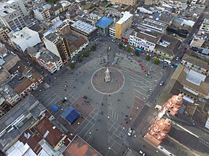
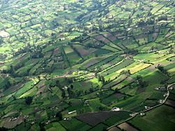
Aerial view of Ipiales and Plaza 20 de Julio
|
|||
|
|||
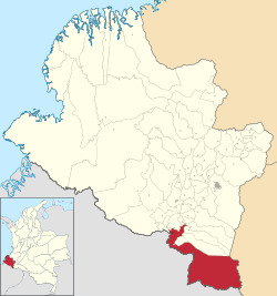
Location of the municipality and town of Ipiales in the Nariño Department of Colombia.
|
|||
| Country | |||
| Department | Nariño Department | ||
| Area | |||
| • Municipality and town | 1,572 km2 (607 sq mi) | ||
| • Urban | 14.27 km2 (5.51 sq mi) | ||
| Elevation | 2,898 m (9,508 ft) | ||
| Population
(2018 census)
|
|||
| • Municipality and town | 116,136 | ||
| • Density | 73.878/km2 (191.34/sq mi) | ||
| • Urban | 77,343 | ||
| • Urban density | 5,420.0/km2 (14,038/sq mi) | ||
| Demonym(s) | Ipialeño | ||
| Time zone | UTC-5 (Colombia Standard Time) | ||
| Website | Official website: http://www.ipiales-narino.gov.co/ | ||
Ipiales is a city in southern Colombia. It is located in the Nariño Department, very close to the border with Ecuador. The city sits high up, about 2,950 meters (9,678 feet) above sea level. This makes it one of the highest cities in Colombia!
Ipiales is about 82 kilometers (51 miles) from Pasto, which is the capital city of the Nariño Department. People sometimes call Ipiales "the city of the green clouds." This is because, especially in the afternoons, you can see greenish clouds floating over the city. A popular local food here is the guinea pig, also known as kuy or kuwi. The city's economy mainly relies on border trade between Colombia and Ecuador.
Contents
Culture and Traditions in Ipiales
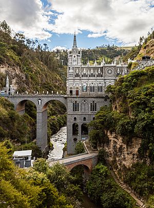
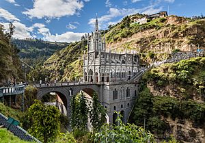
One of the most amazing places to visit in Ipiales is the Las Lajas Cathedral. It's a huge church with incredible architecture. This cathedral is a very important religious site for the Catholic community in the area.
Celebrating Diversity: The Blacks and Whites Carnival
Ipiales is famous for its "Blacks and Whites Carnival." This big festival celebrates the many different cultures and people in the region. During the carnival, people paint each other's faces with makeup. They also use a special white soap called careoca. Many tourists from all over Colombia come to Ipiales to enjoy this exciting event.
A Glimpse into Ipiales' Past
The Rumichaca Bridge is a historic landmark near Ipiales. Long ago, in the early 1500s, this bridge was the northernmost point of the powerful Inca Empire. The Incas took control of this area from the local Pasto people. The Rumichaca Bridge crosses the Carchi River and is about 3 kilometers (1.9 miles) from Ipiales. It marks the border with Ecuador.
Economy and Getting Around Ipiales
The people of Ipiales have several important ways of making a living. These include:
- Trade: Buying and selling goods, especially because it's a border city.
- Small businesses: Many local shops and services.
- Tourism: Visitors come to see places like Las Lajas Cathedral.
- Agriculture: In the countryside, people grow crops and raise animals.
Ipiales is a very important place for trade and travel between Colombia and Ecuador. It's the second most important border crossing in Colombia. Many people and vehicles pass through here every day. The city has an airport called San Luis Airport, which helps people travel by air.
Geography of Ipiales
Ipiales is located in the southwest of Colombia, within the Nariño Department. It's in the high mountains, specifically in an area called Túquerres and Ipiales. The city is only about 3 kilometers (1.9 miles) from the border with Ecuador. It's also 82 kilometers (51 miles) from Pasto.
You can reach Ipiales by the Pan American Highway. This highway continues into Ecuador, leading to the town of Tulcán. To get there, you cross the international Rumichaca Bridge. Rumichaca is a word from the Quechua language, meaning "stone bridge." This bridge crosses the Carchi River.
Mountains and Hills Around Ipiales
The area around Ipiales has many mountains and hills. These include:
- The high plains of Nariño.
- The Guaitara canyon.
- Parts of the Western mountain range.
- The Cofanía valley and parts of the Amazon basin.
- Moors like Mueses and The Palace.
- Hills such as Troy, La Quinta, Culachí, Black, French, Tigre, and Pax.
The land in Ipiales is a bit hilly. It has different climate zones: cold, desert, warm, and medium. The city itself is about 2,900 meters (9,514 feet) above sea level. This makes it one of the highest cities in Colombia and one of the highest cities in the world.
Rivers and Waterways
Ipiales has three main river systems:
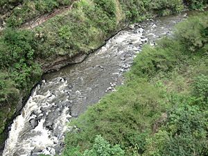
- Guáitara River Basin: This is a very important river. Its smaller rivers include the Boqueron River, Blanco River, Carchi, Morro, Pulcas or Teques, Orejuela, El Rosario, and Cutuaquer. The Guáitara River is known for its dramatic canyons and beautiful scenery. It flows for about 135 kilometers (84 miles) before joining the Patia River.
- Chingual River Basin: This basin includes the Chúnquer or Pun river in its upper part. Its smaller rivers are the San Francisco River, Green, Yamués, and The Cultún.
- San Miguel River Basin: This basin includes the Churuyaco, Sapoyaco, Rumiyaco, Kerosene, Lora, and Rancheria rivers.
Ipiales' Climate and Weather
Ipiales has a unique cool subtropical highland climate. Even though it's near the equator, it's very high up, almost 3,000 meters (9,842 feet) above sea level. This high altitude makes the average temperature around 15°C (59°F). This means the city has spring-like weather all year round! Temperatures rarely go above 20°C (68°F) or below freezing.
Ipiales has a rainy season from October to May and a drier season from June to September. It rains often throughout the year, on about 235 days, with about 925 mm (36.4 inches) of rain annually.
| Climate data for Ipiales (San Luis Airport), elevation 2,961 m (9,715 ft), (1981–2010) | |||||||||||||
|---|---|---|---|---|---|---|---|---|---|---|---|---|---|
| Month | Jan | Feb | Mar | Apr | May | Jun | Jul | Aug | Sep | Oct | Nov | Dec | Year |
| Mean daily maximum °C (°F) | 16.3 (61.3) |
16.4 (61.5) |
16.3 (61.3) |
16.4 (61.5) |
16.0 (60.8) |
15.1 (59.2) |
14.6 (58.3) |
14.9 (58.8) |
15.9 (60.6) |
16.8 (62.2) |
16.9 (62.4) |
16.6 (61.9) |
16.0 (60.8) |
| Daily mean °C (°F) | 11.2 (52.2) |
11.3 (52.3) |
11.4 (52.5) |
11.4 (52.5) |
11.3 (52.3) |
10.6 (51.1) |
10.0 (50.0) |
10.0 (50.0) |
10.5 (50.9) |
11.1 (52.0) |
11.4 (52.5) |
11.3 (52.3) |
11.0 (51.8) |
| Mean daily minimum °C (°F) | 5.8 (42.4) |
6.0 (42.8) |
6.4 (43.5) |
6.6 (43.9) |
6.6 (43.9) |
6.0 (42.8) |
5.1 (41.2) |
4.6 (40.3) |
4.6 (40.3) |
5.6 (42.1) |
6.2 (43.2) |
6.2 (43.2) |
5.8 (42.4) |
| Average precipitation mm (inches) | 73.9 (2.91) |
71.7 (2.82) |
95.2 (3.75) |
102.1 (4.02) |
82.5 (3.25) |
51.4 (2.02) |
40.5 (1.59) |
31.7 (1.25) |
42.6 (1.68) |
84.9 (3.34) |
100.9 (3.97) |
97.2 (3.83) |
874.6 (34.43) |
| Average precipitation days | 19 | 18 | 20 | 21 | 22 | 22 | 20 | 18 | 17 | 19 | 20 | 21 | 236 |
| Average relative humidity (%) | 83 | 83 | 84 | 85 | 85 | 85 | 84 | 82 | 81 | 82 | 83 | 84 | 83 |
| Mean monthly sunshine hours | 133.3 | 107.3 | 99.2 | 111.0 | 127.1 | 129.0 | 139.5 | 139.5 | 129.0 | 130.2 | 123.0 | 130.2 | 1,498.3 |
| Mean daily sunshine hours | 4.3 | 3.8 | 3.2 | 3.7 | 4.1 | 4.3 | 4.5 | 4.5 | 4.3 | 4.2 | 4.1 | 4.2 | 4.1 |
| Source: Instituto de Hidrologia Meteorologia y Estudios Ambientales | |||||||||||||
See Also
 In Spanish: Ipiales para niños
 | John T. Biggers |
 | Thomas Blackshear |
 | Mark Bradford |
 | Beverly Buchanan |


