Tumbes, Peru facts for kids
Quick facts for kids
Tumbes
|
|||
|---|---|---|---|
|
Town
|
|||

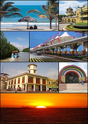
Top left: Punta Sal Beach (Playa Punta Sal), Top right: Tumbes Cathedral, 2nd left: Tumbes River and Tumbes National Reserve Mangrove Sanctuary, 2nd right: Malecon Benavides, 3rd left: A Condor monument and Tumbes Clock Tower in Jerusalem Walks (Paseo Jerusalem), 3rd right: Armas Square (Plaza del Armas), Bottom: Sunset in Pizarro Port
|
|||
|
|||
| Country | |||
| Region | Tumbes | ||
| Province | Tumbes | ||
| District | Tumbes | ||
| Demonym | Tumbesino(a) | ||
| Area | |||
| • Total | 1,800.15 km2 (695.04 sq mi) | ||
| Elevation | 6 m (20 ft) | ||
| Population
(2017)
|
|||
| • Total | 96,946 | ||
| • Estimate
(2015)
|
111,595 | ||
| • Density | 53.8544/km2 (139.4823/sq mi) | ||
Tumbes is a lively city in northwestern Peru. It sits right by the Tumbes River. This city is the capital of the Tumbes Region. It is also the main city for Tumbes Province and Tumbes District.
Tumbes is very close to the border with Ecuador. In 2015, about 111,595 people lived there. The city has its own airport, called Cap. FAP Pedro Canga Rodriguez Airport. Tumbes is also located on the Gulf of Guayaquil, near another town called Zorritos.
Contents
History of Tumbes
Tumbes has a very long history. It started even before the Inca Empire existed. A group of native people called the Tumpis lived here. At its busiest time, about 178,000 people might have lived in the area.
Around the year 1400, the Inca ruler Pachacuti took control of Tumbes. It became a very important place for the Inca Empire. Later, another Inca emperor, Huayna Capac, made Tumbes even bigger. He ordered new roads, houses, and palaces to be built.
Spanish Explorers Arrive
The first Spanish explorer to visit Tumbes was Francisco Pizarro. He came in 1528, at the start of the Spanish conquest of the Inca Empire. People at the time said Tumbes was a very well-organized town.
Pizarro came back in 1532 for a second trip. This time, he faced resistance from a local leader named Chilimaza. This event is known as the Battle of the Manglares. Pizarro eventually won. He is said to have placed a cross there to show the Spanish victory.
Two important people, Felipillo and Yacané, were born in Tumbes. They were among the first Indigenous interpreters in South America. They helped Pizarro and his group during their conquest of Peru.
Colonial Times and Independence
During the time Peru was a Spanish colony, Tumbes did not have many people. It was part of a larger area called the Audiencia of Quito.
When Tumbes decided to become independent from Spain, it chose to join Peru. This was based on the idea that people should choose their own future. At first, another country, Gran Colombia, disagreed. Then, Ecuador also claimed Tumbes.
However, a treaty called the Protocol of Rio de Janeiro was signed in 1942. This agreement officially confirmed that Tumbes belonged to Peru. Even so, full peace between Peru and Ecuador took longer. It was finally achieved in 1998 after a conflict in 1995.
Peruvian President Alberto Fujimori and Ecuadorian President Jamil Mahuad signed a document. In this document, Ecuador agreed that Tumbes and other areas belonged to Peru. This brought a lasting peace between the two nations.
Geography and Climate
Tumbes has a hot and dry climate. It is known as a hot arid climate. Even though it's a desert, it gets about 307.5 millimeters (12.1 inches) of rain each year.
The amount of rain can change a lot because of something called the El Niño Southern Oscillation. During strong El Niño events, Tumbes can get more than twice its usual rainfall.
| Climate data for Tumbes, Peru (Cap. FAP Pedro Canga Rodríguez Airport) extremes 1974-present | |||||||||||||
|---|---|---|---|---|---|---|---|---|---|---|---|---|---|
| Month | Jan | Feb | Mar | Apr | May | Jun | Jul | Aug | Sep | Oct | Nov | Dec | Year |
| Record high °C (°F) | 37.0 (98.6) |
36.8 (98.2) |
39.6 (103.3) |
36.6 (97.9) |
35.6 (96.1) |
40.0 (104.0) |
39.1 (102.4) |
38.0 (100.4) |
33.8 (92.8) |
33.5 (92.3) |
34.1 (93.4) |
35.3 (95.5) |
40.0 (104.0) |
| Mean daily maximum °C (°F) | 30.7 (87.3) |
31.1 (88.0) |
31.3 (88.3) |
31.3 (88.3) |
30.2 (86.4) |
28.6 (83.5) |
27.4 (81.3) |
26.7 (80.1) |
26.9 (80.4) |
27.4 (81.3) |
28.3 (82.9) |
29.7 (85.5) |
29.1 (84.4) |
| Daily mean °C (°F) | 26.4 (79.5) |
27.0 (80.6) |
27.1 (80.8) |
26.9 (80.4) |
26.2 (79.2) |
24.8 (76.6) |
23.8 (74.8) |
22.9 (73.2) |
23.6 (74.5) |
23.9 (75.0) |
24.4 (75.9) |
25.7 (78.3) |
25.2 (77.4) |
| Mean daily minimum °C (°F) | 22.1 (71.8) |
22.3 (72.1) |
22.6 (72.7) |
22.4 (72.3) |
21.7 (71.1) |
20.7 (69.3) |
19.4 (66.9) |
19.0 (66.2) |
19.3 (66.7) |
19.9 (67.8) |
20.4 (68.7) |
21.4 (70.5) |
20.9 (69.6) |
| Record low °C (°F) | 15.6 (60.1) |
16.4 (61.5) |
15.0 (59.0) |
14.2 (57.6) |
14.0 (57.2) |
14.4 (57.9) |
15.0 (59.0) |
12.0 (53.6) |
12.0 (53.6) |
12.6 (54.7) |
14.0 (57.2) |
12.0 (53.6) |
12.0 (53.6) |
| Average rainfall mm (inches) | 21.1 (0.83) |
84.2 (3.31) |
54.7 (2.15) |
63.7 (2.51) |
52.5 (2.07) |
0.6 (0.02) |
6.6 (0.26) |
0.6 (0.02) |
0.3 (0.01) |
1.0 (0.04) |
1.1 (0.04) |
21.1 (0.83) |
307.5 (12.09) |
| Average rainy days (≥ 1.0 mm) | 4.0 | 7.4 | 6.1 | 4.6 | 2.3 | 0.2 | 0.3 | 0.2 | 0.3 | 0.3 | 0.5 | 2.2 | 28.4 |
| Average relative humidity (%) | 74 | 76 | 75 | 76 | 76 | 78 | 79 | 80 | 79 | 78 | 76 | 74 | 77 |
| Source 1: Deutscher Wetterdienst | |||||||||||||
| Source 2: Meteo Climat (record highs and lows) | |||||||||||||
See also
 In Spanish: Tumbes para niños
 | Emma Amos |
 | Edward Mitchell Bannister |
 | Larry D. Alexander |
 | Ernie Barnes |


