Tumeremo facts for kids
Quick facts for kids
Tumeremo
|
|
|---|---|
|
Town
|
|
| Country | |
| State | Bolívar |
| Municipality | Sifontes |
| Time zone | UTC−4 (VET) |
| Postal code |
8057
|
| Dial plan | 0288 |
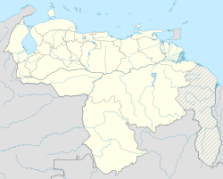
Tumeremo is a town located in the eastern part of Venezuela. It's in the state of Bolívar. This town is like the main office for the Sifontes Municipality. It also serves as an important center for the area called Guayana Essequiba.
Contents
History of Tumeremo
The first people to live in Tumeremo were the Guayan and Kamaracoto Indigenous groups. They came from the savannas near the Yuruari river. These early settlers got their food by hunting, fishing, and farming.
Tumeremo was officially started on January 26, 1788. It was named "Mission of Our Lady of Bethlehem of Tumeremo." This mission was founded by Capuchin monks from Catalonia, a region in Spain. Some of these monks included Fray Mariano de Perafita and Fray Joaquín María de Martorell.
The name "Tumeremo" means "Painted Snake" in the language of the first Indigenous people who lived there. The monks set up several missions. They also created a large farming area. This area focused on raising livestock and growing cotton.
Tumeremo During the Guayana Campaign
During the Guayana Campaign, General Manuel Piar fought against the "realists." These were people loyal to the Spanish king. General Piar wanted to take control of the Spanish missions.
After Tumeremo was freed, the Spanish survivors were captured. They were then sentenced to death. From that time on, Tumeremo became a very important place. It was used as a military camp for the patriot soldiers. These soldiers were led by Simón Bolívar, a famous leader.
After 1830, many Indigenous groups and other communities started to grow around Tumeremo.
British Settlers and General Sifontes
In 1894, some British settlers came from British Guiana. They tried to settle in the area that is now Sifontes Municipality. General Domingo Antonio Sifontes stepped in. On March 2, 1894, he claimed the area near El Dorado for Venezuela. Venezuela then set up a military base there.
General Sifontes successfully removed the settlers from the area. Because of this, he became a local hero to the people of Venezuela in that region.
Climate in Tumeremo
Tumeremo has a tropical monsoon climate. This type of climate is known for having temperatures that stay pretty much the same all year. It also has clear wet and dry seasons.
The wet season in Tumeremo lasts from May to August. The months of February, March, and April are usually quite dry.
| Climate data for Tumeremo (1991–2020) | |||||||||||||
|---|---|---|---|---|---|---|---|---|---|---|---|---|---|
| Month | Jan | Feb | Mar | Apr | May | Jun | Jul | Aug | Sep | Oct | Nov | Dec | Year |
| Record high °C (°F) | 35.3 (95.5) |
38.2 (100.8) |
39.6 (103.3) |
37.9 (100.2) |
35.9 (96.6) |
38.0 (100.4) |
37.7 (99.9) |
35.4 (95.7) |
35.9 (96.6) |
38.2 (100.8) |
37.7 (99.9) |
35.6 (96.1) |
39.6 (103.3) |
| Mean daily maximum °C (°F) | 30.7 (87.3) |
32.1 (89.8) |
33.0 (91.4) |
33.8 (92.8) |
32.2 (90.0) |
30.7 (87.3) |
30.6 (87.1) |
31.3 (88.3) |
32.2 (90.0) |
32.6 (90.7) |
31.7 (89.1) |
30.7 (87.3) |
31.8 (89.2) |
| Daily mean °C (°F) | 24.0 (75.2) |
24.9 (76.8) |
25.5 (77.9) |
26.6 (79.9) |
25.4 (77.7) |
24.6 (76.3) |
24.3 (75.7) |
24.7 (76.5) |
25.6 (78.1) |
25.7 (78.3) |
25.3 (77.5) |
24.2 (75.6) |
25.1 (77.2) |
| Mean daily minimum °C (°F) | 21.5 (70.7) |
21.7 (71.1) |
22.1 (71.8) |
22.9 (73.2) |
22.7 (72.9) |
22.5 (72.5) |
22.1 (71.8) |
22.1 (71.8) |
22.5 (72.5) |
22.7 (72.9) |
22.7 (72.9) |
21.9 (71.4) |
22.3 (72.1) |
| Record low °C (°F) | 15.5 (59.9) |
16.8 (62.2) |
14.5 (58.1) |
17.6 (63.7) |
17.3 (63.1) |
16.6 (61.9) |
18.3 (64.9) |
12.7 (54.9) |
17.0 (62.6) |
17.4 (63.3) |
18.7 (65.7) |
17.2 (63.0) |
12.7 (54.9) |
| Average precipitation mm (inches) | 102.1 (4.02) |
61.0 (2.40) |
47.3 (1.86) |
73.9 (2.91) |
199.7 (7.86) |
289.1 (11.38) |
238.0 (9.37) |
204.9 (8.07) |
110.3 (4.34) |
100.6 (3.96) |
148.3 (5.84) |
135.5 (5.33) |
1,710.7 (67.35) |
| Average precipitation days (≥ 1.0 mm) | 12.1 | 8.1 | 6.1 | 6.9 | 13.8 | 19.7 | 18.0 | 13.5 | 7.8 | 8.8 | 11.2 | 13.9 | 139.9 |
| Source: NOAA | |||||||||||||
See also
 In Spanish: Tumeremo para niños
 | Roy Wilkins |
 | John Lewis |
 | Linda Carol Brown |


