Tuna, San Germán, Puerto Rico facts for kids
Quick facts for kids
Tuna
|
|
|---|---|
|
Barrio
|
|

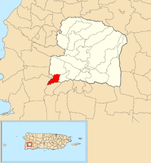
Location of Tuna within the municipality of San Germán shown in red
|
|
| Commonwealth | |
| Municipality | |
| Area | |
| • Total | 0.93 sq mi (2.4 km2) |
| • Land | 0.93 sq mi (2.4 km2) |
| • Water | 0 sq mi (0 km2) |
| Elevation | 528 ft (161 m) |
| Population
(2010)
|
|
| • Total | 88 |
| • Density | 94.6/sq mi (36.5/km2) |
| Source: 2010 Census | |
| Time zone | UTC−4 (AST) |
Tuna is a small area, or barrio, located in the town of San Germán, Puerto Rico. In 2010, only 88 people lived there. It is a quiet place in the beautiful island of Puerto Rico.
Exploring Tuna's Past
Puerto Rico became a part of the United States after the Spanish–American War. This war ended with the Treaty of Paris of 1898. After the treaty, Puerto Rico became an area connected to the U.S. but not fully a state. It is called an unincorporated territory.
Population Changes Over Time
In 1899, the United States government counted everyone living in Puerto Rico. This count is called a census. The census found that Tuna and a nearby area called Maresúa had a total of 1,044 people. Over the years, the number of people living in Tuna has changed. You can see how the population has grown or shrunk in the table below.
| Historical population | |||
|---|---|---|---|
| Census | Pop. | %± | |
| 1910 | 678 | — | |
| 1920 | 683 | 0.7% | |
| 1930 | 617 | −9.7% | |
| 1940 | 615 | −0.3% | |
| 1950 | 570 | −7.3% | |
| 1980 | 294 | — | |
| 1990 | 367 | 24.8% | |
| 2000 | 139 | −62.1% | |
| 2010 | 88 | −36.7% | |
| U.S. Decennial Census 1900 (n/a) 1910-1930 1930-1950 1980-2000 2010 |
|||
Discover More About Puerto Rico
 In Spanish: Tuna (San Germán) para niños
- List of communities in Puerto Rico
 | William L. Dawson |
 | W. E. B. Du Bois |
 | Harry Belafonte |


