Turton, South Dakota facts for kids
Quick facts for kids
Turton, South Dakota
|
|
|---|---|

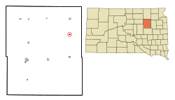
Location in Spink County and the state of South Dakota
|
|
| Country | United States |
| State | South Dakota |
| County | Spink |
| Incorporated | 1905 |
| Area | |
| • Total | 0.37 sq mi (0.95 km2) |
| • Land | 0.37 sq mi (0.95 km2) |
| • Water | 0.00 sq mi (0.00 km2) |
| Elevation | 1,329 ft (405 m) |
| Population
(2020)
|
|
| • Total | 55 |
| • Density | 149.86/sq mi (57.90/km2) |
| Time zone | UTC-6 (Central (CST)) |
| • Summer (DST) | UTC-5 (CDT) |
| ZIP code |
57477
|
| Area code(s) | 605 |
| FIPS code | 46-64540 |
| GNIS feature ID | 1267606 |
Turton is a small town located in Spink County, South Dakota, in the United States. In 2020, about 55 people lived there. For many years, Turton had its own school, Turton High School, from 1915 to 1956. After that, students went to high school in nearby Doland.
Contents
Turton's History and Origins
Turton was officially planned and mapped out in 1886. It got its name from a place called Turton, in England. This was the hometown of one of the first people to settle in the area. For a short time, it was also known by another name, St. Paul. A post office has been open in Turton since 1887, helping people send and receive mail for over a century!
Geography of Turton
Turton is a small town in terms of size. According to the United States Census Bureau, the town covers a total area of about 0.95 square kilometers (0.37 square miles). All of this area is land, meaning there are no lakes or large rivers within the town limits.
School Days: Turton High School
Turton High School was an important part of the town's history. It opened its doors in 1915, providing education for students in Turton. However, the school closed in 1956. This happened because there wasn't enough money, not enough teachers, and too few students to get help from the state. After the high school closed, students from Turton began attending high school in the nearby town of Doland.
Population Changes in Turton
The number of people living in Turton has changed quite a bit over the years. Here's a look at how the population has grown and shrunk:
| Historical population | |||
|---|---|---|---|
| Census | Pop. | %± | |
| 1910 | 240 | — | |
| 1920 | 243 | 1.3% | |
| 1930 | 323 | 32.9% | |
| 1940 | 180 | −44.3% | |
| 1950 | 201 | 11.7% | |
| 1960 | 140 | −30.3% | |
| 1970 | 121 | −13.6% | |
| 1980 | 101 | −16.5% | |
| 1990 | 76 | −24.8% | |
| 2000 | 61 | −19.7% | |
| 2010 | 48 | −21.3% | |
| 2020 | 55 | 14.6% | |
| U.S. Decennial Census | |||
Turton's Population in 2010
In 2010, there were 48 people living in Turton. These people lived in 26 different homes, and 13 of these were families. The town's population density was about 130 people per square mile. This means that for every square mile of land, there were about 130 people.
Everyone living in Turton at that time was White. About half of the homes were married couples living together. Nearly half of all homes had only one person living in them. Many of these single-person homes (about 30%) were people aged 65 or older.
The average age of people in Turton in 2010 was 53.5 years old. About 10% of the residents were under 18 years old. Most people were between 45 and 64 years old (about 46%). Also, about 27% of the people were 65 years old or older. Slightly more than half of the residents were male (56.3%), and the rest were female (43.8%).
See also
 In Spanish: Turton (Dakota del Sur) para niños
 | William L. Dawson |
 | W. E. B. Du Bois |
 | Harry Belafonte |

