Turton, Lancashire facts for kids
Quick facts for kids Turton |
|
|---|---|
 St Anne's Church |
|
| District |
|
| Shire county | |
| Region | |
| Country | England |
| Sovereign state | United Kingdom |
| Police | Lancashire |
| Fire | Lancashire |
| Ambulance | North West |
| EU Parliament | North West England |
Turton is a historic area in the North West of England. It is located north of Bolton and south of Blackburn. Turton is part of the counties of Lancashire and Greater Manchester.
In the past, Turton was a "township" within the old parish of Bolton le Moors. A township was like a small local area with its own rules. The main village in this old township is now called Chapeltown. Today, the Turton area is split into two parts. North Turton is in the borough of Blackburn with Darwen. South Turton is in the borough of Bolton. Even though it's not an official area anymore, the name Turton is still used for this historic place.
Contents
What's in a Name?
The name Turton means "Thor's village." Thor was a powerful god in old Norse stories. The name comes from the Old Norse name Thor and the Old English word tun, which means "farm" or "village."
People first wrote the name as Thirtun in 1185. Later, it was called Turton in 1212. Other old spellings include Thurton in 1277 and Terton in 1282. This Viking-sounding name makes sense because other places nearby also have names from the Norse language.
Turton's Past
Early History
Between Chapeltown and Egerton, you can find remains of very old stone circles. These circles are on the moorland at Cheetham Close. They were built during the Bronze Age, thousands of years ago. These stone circles are the first signs that people lived in the Turton area.
One of the circles was about 15 meters (51 feet) wide. Some of its stones were several feet tall. In the 1800s, many people visited the site. This made the local farmer, who rented land from Turton Tower, upset. In 1871, he broke up the circle using horses and hammers. Luckily, before this happened, a historian named Gilbert French drew pictures and maps of the site. His detailed notes are now in the Bolton Reference Library.
South of this site, there are remains of another stone circle. This one is a bit bigger. People think it might have been an area to keep farm animals.
Turton Tower
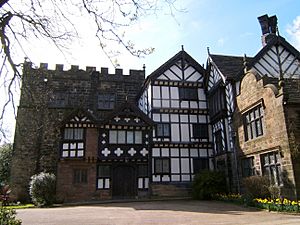
Turton Tower in Chapeltown was once home to the Lords of the Manor of Turton. It has been around since the 1100s. The first mention of Turton as a "Manor" (a large estate) was around 1200. At that time, it was part of a bigger area controlled from Manchester.
The Orrell family took over Turton Tower in 1420. They rebuilt the strong, tall part of the tower, called a "pele tower," in 1420. Around 1596, they made it taller and raised the floors. This created three big rooms inside. In the 1600s, wooden farmhouse buildings were added to the east and north sides of the Tower. An entrance hall was also built.
In 1628, the Orrells sold Turton Tower to Humphrey Chetham. He was a rich merchant from Manchester. Humphrey Chetham later started Chetham's Library and Chetham's School of Music. After him, the Tower was passed down to his family members. They rented it out to farmers for many years.
In 1835, James Kay bought the tower. He was an inventor who used steam power to spin flax (a plant used to make linen). Kay tried to fix up the tower. He worked on many rooms, but he sometimes added things that weren't there originally. James Kay sold the tower to Elizabeth and Anne Appleton. They rented it to William Rigg, who made printed fabric called calico. William's daughter, Ellen, wrote about her childhood at Turton Tower. Her memories are now a book called "Victorian Children at Turton Tower".
In 1903, Sir Lees Knowles, 1st Baronet bought the tower for £3,875. He was a Member of Parliament and made his money from his family's coal mines. After he died in 1929, his wife, Lady Nina Knowles, gave Turton Tower to the local council in 1930. It then became the council's meeting place.
In 1974, local government areas changed. Turton was split, and the tower became part of Blackburn with Darwen. It was looked after by the Lancashire County Museums Service. Now, Blackburn with Darwen Council manages the tower. There is also a Summerhouse near Turton Tower that is a very old and important building.
Local Industries
After the Industrial Revolution, many important industries grew in Turton. These included cotton mills, where cotton was spun into thread and fabric. There were also printworks, which printed patterns on cloth. Bleachworks cleaned and whitened fabrics. An iron foundry made metal items, and a paper mill produced paper.
The Black Rock Mill complex was a large site used for bleaching and printing. It stopped working in the 1950s. Horrobin Mill Bleachworks was one of the oldest bleachworks in the Bolton area. It closed in 1937 after 150 years of business.
Turton's Geography
The old Turton township covered about 4,614 acres (18.67 square kilometers). It stretched nearly 5 miles (8 kilometers) to the north and northwest. The middle part of Turton is covered by high moorland. Turton Heights is about 1,100 feet (335 meters) high. Turton Moor is even higher at 1,280 feet (390 meters).
The Bradshaw Brook river formed the northern and eastern edges of Turton. This river was dammed to create two reservoirs. These reservoirs stored water for the Bolton Waterworks.
The main road from Bolton split at the southern end of Turton. One branch went through Turton village to Edgworth and Darwen. The other branch went through Egerton and over Charters Moss to Blackburn.
Population Changes
| Population changes for the chapelry/civil parish of Turton | |||||||||||||||||||||||||||||||||||||||||
|---|---|---|---|---|---|---|---|---|---|---|---|---|---|---|---|---|---|---|---|---|---|---|---|---|---|---|---|---|---|---|---|---|---|---|---|---|---|---|---|---|---|
|
|
|
|||||||||||||||||||||||||||||||||||||||
| Source(s): (a) Local population statistics. (b) Turton Ch/CP: Total Population. (c) Four Bolton Directories. In 1961 the parish had a population of 13,698. | |||||||||||||||||||||||||||||||||||||||||
Places of Worship
Turton had two old churches, called "chapels of ease," in the ancient parish of Bolton le Moors. These were part of the Church of England.
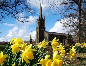
The first chapel was in Chapeltown. It was built in 1111 and first named after St. Bartholomew. Later, in the 1700s, it was renamed after St Anne. This building, known as the Chapel of Turton, was rebuilt in 1630 and again in 1779. The current Parish Church of St Anne was built between 1840 and 1841.
The second chapel was at Walmsley, which is the old name for Egerton. No one knows exactly when Walmsley Chapel was built. Records show it existed in 1500. The chapel was rebuilt in 1771 and then taken down in 1839. The current Christ Church, Walmsley, in Egerton, was opened in 1840.
Other churches also came to Turton. A mission church opened in Toppings in 1897. The Wesleyan Methodists had chapels in Turton, Egerton, and Toppings. There were also Congregational chapels in Turton and Egerton. The old Nonconformist chapel from 1713 later became a Unitarian church. The Roman Catholic church of St. Aldhelm in Turton opened in 1903.
Sports in Turton
Turton Football Club is one of the oldest football clubs in Britain. It might even be the oldest! The club started in December 1871. It was founded by men from Chapeltown in Turton.
Today, the club plays at Thomasson Fold in Edgworth. Their old ground in Chapeltown is still used by the Old Boltonians team. Many people believe this old pitch is the oldest football field in the world that is still used today!
 | Victor J. Glover |
 | Yvonne Cagle |
 | Jeanette Epps |
 | Bernard A. Harris Jr. |


