Twin Peaks (Elko County, Nevada) facts for kids
Quick facts for kids Twin Peaks |
|
|---|---|

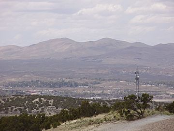
Twin Peaks viewed from Nevada State Route 227
|
|
| Highest point | |
| Elevation | 7,479 ft (2,280 m) NAVD 88 |
| Prominence | 605 ft (184 m) |
| Geography | |
| Location | Elko County, Nevada, U.S. |
| Parent range | Adobe Range |
| Topo map | KITTRIDGE SPRINGS |
| Climbing | |
| Easiest route | A four-wheel drive dirt road leads southeast from Nevada State Route 225 to radio facilities on the summits |
Twin Peaks are two special mountains found in Elko County, Nevada, in the United States. They are part of a mountain chain called the Adobe Range. These peaks are named "Twin" because they stand close together, like two siblings.
Contents
Discover the Twin Peaks
The Twin Peaks are a pair of mountains. One is called the East Twin, and the other is the West Twin. The East Twin is just a little bit taller than its partner. These mountains reach high into the sky. The East Twin stands at about 7,479 feet (2,279 meters) above sea level. That's pretty tall!
Where are the Twin Peaks Located?
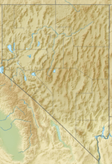
You can find the Twin Peaks in the northeastern part of Nevada. They are specifically located in Elko County. This area is known for its wide-open spaces and beautiful natural landscapes. The mountains are part of the larger Adobe Range.
What's on Top of the Peaks?
Both of the Twin Peaks have several radio towers on their summits. These towers are important for sending and receiving radio signals. They help with communication across the area. Imagine how far those signals can travel from such a high point!
You can reach the top of these peaks by a dirt road. This road is usually used by vehicles with four-wheel drive. It helps people get to the radio facilities located at the very top.
Amazing Views from the Summit
From the top of the East Twin, you can see a full 360-degree view of the land around you. It's like being on top of the world! You can see for miles in every direction. This wide view shows the beautiful Nevada landscape.
 | Bayard Rustin |
 | Jeannette Carter |
 | Jeremiah A. Brown |


