Adobe Range facts for kids
Quick facts for kids Adobe Range |
|
|---|---|

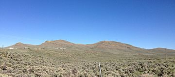
Twin Peaks in the Adobe Range northwest of Elko, Nevada
|
|
| Highest point | |
| Elevation | 2,479 m (8,133 ft) |
| Geography | |
| Country | United States |
| State | Nevada |
| District | Elko County |
| Range coordinates | 40°57′10.704″N 115°47′55.257″W / 40.95297333°N 115.79868250°W |
| Topo map | USGS Kittridge Springs |
The Adobe Range is a smaller mountain range found in Nevada, a state in the western United States. It stretches for about 80 miles (129 km) from north to south. This mountain area covers about 314 square miles (813 square km). The range is located northwest and north of Elko, Nevada, a city in the state.
The highest point in the Adobe Range is an unnamed peak that reaches 8,134 feet (2,479 meters) high. Some other well-known peaks include Sherman Peak, which is 7,522 feet (2,293 meters) tall. There are also Twin Peaks (East and West), standing at 7,475 feet (2,278 meters) and 7,472 feet (2,277 meters) respectively. Another notable spot is The Buttes, at 6,674 feet (2,034 meters).
What Grows in the Adobe Range?
The main type of plants you'll find in the Adobe Range is called sagebrush steppe. This means there are many sagebrush plants and different kinds of grasses. It's a dry environment, but these plants are well-suited to it.
Several small streams flow through the range. These streams only flow sometimes, especially after rain or snowmelt. They eventually feed into the Humboldt River, which runs along the south and east sides of the mountain range.
Who Owns the Land?
The land in the Adobe Range is split almost evenly. About half of it is owned by private individuals or companies. The other half is managed by the Bureau of Land Management (BLM). The BLM is a U.S. government agency that takes care of public lands.
The southern part of the Adobe Range is close to the city of Elko. This area is home to the Elko Snobowl, which is a ski area. People can go there to ski and snowboard during the winter. In the northern part of the range, you can find several coal mines. These mines dig up coal, which is used as a fuel source.
Climbing in the Adobe Range
The Adobe Range is becoming a popular place for rock climbing. Climbers can find routes on conglomerate rock. This type of rock is made up of many different pebbles and stones cemented together.
The climbing routes here range in difficulty from YDS 5.6 to 5.10. YDS stands for the Yosemite Decimal System, which is a way to rate how hard a climb is. A 5.6 route is fairly easy, while a 5.10 route is more challenging and requires good climbing skills.
See also
 In Spanish: Sierra Adobe para niños
 | Kyle Baker |
 | Joseph Yoakum |
 | Laura Wheeler Waring |
 | Henry Ossawa Tanner |


