Ugashik-Peulik facts for kids
Quick facts for kids Ugashik-Peulik |
|
|---|---|

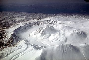
Aerial view, looking southwest, of Ugashik caldera adjacent to Peulik volcano.
|
|
| Highest point | |
| Elevation | 4,836 ft (1,474 m) |
| Geography | |
| Location | Lake and Peninsula Borough, Alaska, U.S. |
| Parent range | Aleutian Range |
| Topo map | USGS |
| Geology | |
| Mountain type | Stratovolcano |
| Volcanic arc/belt | Aleutian Arc |
| Last eruption | 1814 |
Ugashik-Peulik is a large stratovolcano located in Alaska, United States. It stands on the Alaska Peninsula, south of Becharof Lake. This volcano is part of the Aleutian Range, a long chain of mountains. Its last known eruption happened in the year 1814.
Contents
Discovering Ugashik-Peulik Volcano
Ugashik-Peulik is an interesting natural landmark in Alaska. It is known for its unique shape and location. This volcano helps us understand Earth's powerful forces.
Where is Ugashik-Peulik Located?
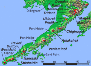
Ugashik-Peulik is found in the Lake and Peninsula Borough. This area is on the Alaska Peninsula. The volcano is also close to Becharof Lake, a large body of water. It is part of the Aleutian Range, a mountain chain.
What is a Stratovolcano?
A stratovolcano is a tall, cone-shaped volcano. It is built up by many layers of hardened lava, ash, and rocks. These volcanoes are known for their explosive eruptions. Mount Fuji in Japan is another famous stratovolcano.
When Did Ugashik-Peulik Last Erupt?
The last time Ugashik-Peulik erupted was in 1814. This means it has been quiet for over 200 years. Scientists keep an eye on volcanoes like this. They monitor them for any signs of activity.
The Aleutian Range and Alaskan Volcanoes
Ugashik-Peulik is one of many volcanoes in Alaska. Alaska is part of the "Ring of Fire." This is an area around the Pacific Ocean. It has many active volcanoes and earthquakes.
A Chain of Fire
The Aleutian Range is a long chain of mountains. Many of these mountains are volcanoes. They stretch across the Alaska Peninsula. This range is part of the larger Aleutian Arc. The arc is formed by tectonic plates moving. This movement causes volcanoes to form.
See also
 In Spanish: Ugashik-Peulik para niños
 | Toni Morrison |
 | Barack Obama |
 | Martin Luther King Jr. |
 | Ralph Bunche |


