Unadilla Township, Michigan facts for kids
Quick facts for kids
Unadilla Township, Michigan
|
|
|---|---|

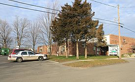
Unadilla Township Offices and Police Department
|
|

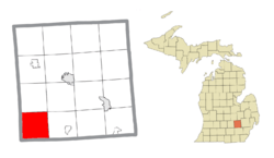
Location within Livingston County
|
|
| Country | United States |
| State | Michigan |
| County | Livingston |
| Established | 1835 |
| Area | |
| • Total | 34.7 sq mi (89.9 km2) |
| • Land | 33.8 sq mi (87.5 km2) |
| • Water | 0.9 sq mi (2.4 km2) |
| Elevation | 961 ft (293 m) |
| Population
(2020)
|
|
| • Total | 3,333 |
| • Density | 96.02/sq mi (37.075/km2) |
| Time zone | UTC-5 (Eastern (EST)) |
| • Summer (DST) | UTC-4 (EDT) |
| ZIP code(s) | |
| Area code(s) | 734 |
| FIPS code | 26-81240 |
| GNIS feature ID | 1627183 |
Unadilla Township is a special kind of local government area called a civil township. It is located in the southwest part of Livingston County, Michigan, in the United States. In 2020, about 3,333 people lived there.
Contents
Exploring Unadilla Township: What Communities Are Here?
Unadilla Township does not have any big cities or towns that are officially set up as their own governments. Instead, it has several smaller communities and historic places.
Discovering Gregory, a Key Community
Gregory started as a train station in 1884. It was built on the farm of Halstead Gregory. He opened a store near the station and became the first postmaster. The main office for Unadilla Township is located in Gregory.
Historic Plainfield: An Early Settlement
Plainfield was once a popular spot for Native American trails and camps. The first people to buy land here were Jacob Dunn and Levi Clawson in 1835. Philip Dyer joined them in 1836. The community was first called "Dyersburg." However, the post office, which opened in 1837, was named "Plainfield" after a town in New Jersey. The post office closed in 1913.
Other Small Communities in Unadilla
- Bullis Crossing is found where Barton Road and M-36 meet.
- Kaiserville is located on the west side of Patterson Lake.
- Unadilla was first known as "Milan." A post office opened in 1834, but because another town was already named Milan, it was called "Unadilla." A plan for a "Village of Unadilla" was made in a different spot, so this one became "East Unadilla." It later became known simply as "Unadilla."
- Williamsville is northeast of Williamsville Lake. It was first planned as the Village of Unadilla in 1837. This plan was later canceled, and the area became known as Williamsville.
The Story of Unadilla Township: A Brief History
Unadilla Township was officially created on March 26, 1835. At first, it included more land, like Iosco Township to the north and part of Lyndon Township to the south. The first meeting for the township was held in April 1835. Livingston County's government was not set up until 1836, so Unadilla Township was first part of Washtenaw County. In 1838, Iosco Township became separate, and the southern part was given to Lyndon Township. This is how Unadilla Township got its current borders.
The very first land purchase in the township happened on June 20, 1833. Eli Ruggles bought the land with his brother-in-law, Amos Williams. After Ruggles passed away, Williams returned in late 1833 with his family. They built a sawmill, which started working in the spring of 1834.
Unadilla's Landscape: Geography and Natural Features
Unadilla Township is in the southwest corner of Livingston County. It shares borders with Ingham County to the west and Washtenaw and Jackson counties to the south.
Two main state roads run through the township:
- M-36 goes through the middle of the township. It leads east about 7 miles to Pinckney and northwest about 16 miles to Dansville.
- M-106 starts in Gregory at M-36. It goes southwest about 27 miles to Jackson.
The township covers about 89.9 square kilometers (34.7 square miles) in total. Most of this area, about 87.5 square kilometers (33.8 square miles), is land. The rest, about 2.4 square kilometers (0.9 square miles), is water.
The Lakelands Trail State Park also runs through Unadilla Township, offering a great place for outdoor activities.
Who Lives in Unadilla? Understanding the Population
Based on the census from 2000, there were 3,190 people living in Unadilla Township. These people lived in 1,156 households, and 877 of these were families.
Population Breakdown by Age
The population in the township was spread out by age:
- 26.0% were under 18 years old.
- 6.7% were between 18 and 24 years old.
- 31.2% were between 25 and 44 years old.
- 25.5% were between 45 and 64 years old.
- 10.7% were 65 years old or older.
The average age in the township was 38 years.
Household Income and Poverty Levels
In 2000, the average income for a household in the township was $52,433. For families, the average income was $58,036. About 2.5% of families and 3.2% of all people in the township lived below the poverty line. This included 1.8% of those under 18 and 4.4% of those 65 or older.
See also
 In Spanish: Municipio de Unadilla para niños
 | Georgia Louise Harris Brown |
 | Julian Abele |
 | Norma Merrick Sklarek |
 | William Sidney Pittman |


