Unity, Kennebec County, Maine facts for kids
Quick facts for kids
Unity, Maine
|
|
|---|---|

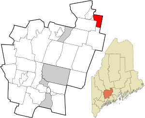
Location in Kennebec County and the state of Maine.
|
|
| Country | United States |
| State | Maine |
| County | Kennebec |
| Area | |
| • Total | 10.4 sq mi (26.9 km2) |
| • Land | 10.4 sq mi (26.8 km2) |
| • Water | 0.01 sq mi (0.03 km2) |
| Elevation | 200 ft (61 m) |
| Population
(2020)
|
|
| • Total | 36 |
| • Density | 3.46/sq mi (1.338/km2) |
| Time zone | UTC-5 (Eastern (EST)) |
| • Summer (DST) | UTC-4 (EDT) |
| ZIP Code |
04988 (Unity)
|
| Area code(s) | 207 |
| FIPS code | 23-78190 |
| GNIS feature ID | 582774 |
Unity is a small area in Kennebec County, Maine, in the United States. It's called an unincorporated territory, which means it doesn't have its own local government like a city or town. Instead, it's managed by the county or state.
In 2020, only 36 people lived in Unity. This area used to be a "plantation," which was a type of settlement in Maine. But in 1942, it stopped having its own local government.
Contents
Where is Unity Located?
Unity is in Kennebec County, Maine. It covers about 10.4 square miles (26.9 square kilometers) of land. Almost all of this area is land, with only a tiny bit of water.
The area is crossed by Maine State Route 139. Unity is surrounded by other towns:
- To the north is Burnham.
- To the east is the town of Unity.
- To the south is Albion.
- To the west is Benton.
Who Lives in Unity?
The number of people living in Unity has changed over many years. Here's a quick look at its population history:
| Historical population | |||
|---|---|---|---|
| Census | Pop. | %± | |
| 1860 | 54 | — | |
| 1870 | 68 | 25.9% | |
| 1880 | 61 | −10.3% | |
| 1890 | 62 | 1.6% | |
| 1900 | 50 | −19.4% | |
| 1910 | 56 | 12.0% | |
| 1920 | 46 | −17.9% | |
| 1930 | 34 | −26.1% | |
| 1940 | 52 | 52.9% | |
| 1950 | 44 | −15.4% | |
| 1960 | 53 | 20.5% | |
| 1970 | 45 | −15.1% | |
| 1980 | 37 | −17.8% | |
| 1990 | 36 | −2.7% | |
| 2000 | 31 | −13.9% | |
| 2010 | 43 | 38.7% | |
| 2020 | 36 | −16.3% | |
| U.S. Decennial Census | |||
Population in 2000
In the year 2000, there were 31 people living in Unity. These people lived in 15 different homes, and 9 of these were families. The area had about 3 people per square mile.
Most of the people (96.77%) were White. A small number (3.23%) were Native American.
Households and Families
Out of the 15 homes in 2000:
- 20% had children under 18 living there.
- 46.7% were married couples living together.
- 13.3% were homes where a woman was the head of the house, and her husband was not present.
- 40% were not families (meaning people living alone or with roommates).
On average, about 2 people lived in each home. For families, the average was about 2.67 people.
Age Groups
The people in Unity in 2000 were of different ages:
- 19.4% were under 18 years old.
- 3.2% were between 18 and 24 years old.
- 16.1% were between 25 and 44 years old.
- 48.4% were between 45 and 64 years old.
- 12.9% were 65 years old or older.
The average age of people in Unity was 50 years old. For every 100 females, there were about 107 males.
Income Information
In 2000, the average income for a household in Unity was $17,917 per year. For families, the average income was $25,000 per year.
Men earned about $18,750 per year on average, while women earned about $13,750 per year. The average income for each person in Unity was $9,500.
About 16.7% of families and 31.7% of all people in Unity earned less than a certain amount of money, meaning they were living with very low incomes. This included 33.3% of those under 18 years old.
See also
 In Spanish: Unity (condado de Kennebec, Maine) para niños
 | Lonnie Johnson |
 | Granville Woods |
 | Lewis Howard Latimer |
 | James West |

