Burnham, Maine facts for kids
Quick facts for kids
Burnham, Maine
|
|
|---|---|

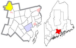
Location of Burnham (in yellow) in Waldo County and the state of Maine
|
|
| Country | United States |
| State | Maine |
| County | Waldo |
| Area | |
| • Total | 41.22 sq mi (106.76 km2) |
| • Land | 38.89 sq mi (100.72 km2) |
| • Water | 2.33 sq mi (6.03 km2) |
| Elevation | 200 ft (61 m) |
| Population
(2020)
|
|
| • Total | 1,096 |
| • Density | 28/sq mi (10.9/km2) |
| Time zone | UTC-5 (Eastern (EST)) |
| • Summer (DST) | UTC-4 (EDT) |
| ZIP code |
04922
|
| Area code(s) | 207 |
| FIPS code | 23-09270 |
| GNIS feature ID | 0582379 |
Burnham is a small town located in Waldo County, Maine, in the United States. In 2020, the town had a population of 1,096 people. It's a quiet place known for its natural beauty and connection to local waterways.
Contents
Exploring Burnham's Geography
Burnham covers a total area of about 41.22 square miles (106.76 square kilometers). Most of this area, about 38.89 square miles (100.72 square kilometers), is land. The rest, about 2.33 square miles (6.03 square kilometers), is water. A big part of this water is Unity Pond, a local lake.
The town's land is naturally watered by two streams: Twentyfive Mile Stream and the Sebasticook River. These waterways help shape the landscape.
How to Get Around Burnham
Burnham is easy to reach because major roads pass through it. These include Interstate 95, which is a big highway, and Maine State Route 11 and 100.
Neighboring Towns of Burnham
Burnham shares its borders with several other towns. To the north, you'll find Pittsfield. To the northeast is Detroit. On the east side, it borders Troy. To the south, it's next to Unity and Unity Township. Finally, to the west, Burnham borders Clinton.
Understanding Burnham's Population
The population of Burnham has changed over many years. Every ten years, the United States counts its population in what's called a census. This helps us understand how many people live in a place.
| Historical population | |||
|---|---|---|---|
| Census | Pop. | %± | |
| 1830 | 409 | — | |
| 1840 | 602 | 47.2% | |
| 1850 | 784 | 30.2% | |
| 1860 | 857 | 9.3% | |
| 1870 | 788 | −8.1% | |
| 1880 | 967 | 22.7% | |
| 1890 | 846 | −12.5% | |
| 1900 | 766 | −9.5% | |
| 1910 | 733 | −4.3% | |
| 1920 | 643 | −12.3% | |
| 1930 | 664 | 3.3% | |
| 1940 | 643 | −3.2% | |
| 1950 | 706 | 9.8% | |
| 1960 | 755 | 6.9% | |
| 1970 | 802 | 6.2% | |
| 1980 | 951 | 18.6% | |
| 1990 | 961 | 1.1% | |
| 2000 | 1,142 | 18.8% | |
| 2010 | 1,164 | 1.9% | |
| 2020 | 1,096 | −5.8% | |
| U.S. Decennial Census | |||
Burnham's 2010 Census Snapshot
In 2010, the census showed that 1,164 people lived in Burnham. These people lived in 502 different homes, and 332 of these were families.
The population density was about 29.9 people for every square mile (11.5 people per square kilometer) of land. This means the town isn't very crowded. There were also 714 housing units, which are places where people can live.
Most people in Burnham, about 98.4%, identified as White. A small number of people identified as African American, Native American, or Asian. Some people also identified with two or more races. About 0.3% of the population identified as Hispanic or Latino.
Homes and Families in Burnham
Out of the 502 homes in Burnham, about 28.5% had children under 18 living there. Nearly half of the homes (48.8%) were married couples living together. Some homes had a female head of household without a husband (10.2%), or a male head of household without a wife (7.2%). About 33.9% of homes were not families.
About 27.1% of all homes had just one person living there. And 9% of homes had someone living alone who was 65 years old or older. On average, there were 2.32 people in each home, and 2.75 people in each family.
Age Groups in Burnham
The median age in Burnham in 2010 was 43.3 years old. This means half the people were younger than 43.3, and half were older.
- About 20.5% of residents were under 18 years old.
- About 9.5% were between 18 and 24 years old.
- About 22.3% were between 25 and 44 years old.
- About 33.7% were between 45 and 64 years old.
- About 13.9% were 65 years old or older.
In terms of gender, 52.3% of the population was male, and 47.7% was female.
See also
 In Spanish: Burnham (Maine) para niños
 | Delilah Pierce |
 | Gordon Parks |
 | Augusta Savage |
 | Charles Ethan Porter |

