Upper Burnie, Tasmania facts for kids
Quick facts for kids Upper BurnieBurnie, Tasmania |
|||||||||||||||
|---|---|---|---|---|---|---|---|---|---|---|---|---|---|---|---|

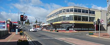
Mount Street at the intersection with Pine Avenue
|
|||||||||||||||
| Population | 1,821 (2016 census) | ||||||||||||||
| Postcode(s) | 7320 | ||||||||||||||
| Location | 3 km (2 mi) S of Burnie | ||||||||||||||
| LGA(s) | City of Burnie | ||||||||||||||
| Region | North-west and west | ||||||||||||||
| State electorate(s) | Braddon | ||||||||||||||
| Federal Division(s) | Braddon | ||||||||||||||
|
|||||||||||||||
Upper Burnie is a neighbourhood located in the city of Burnie in north-west Tasmania. It's part of the Burnie local government area. This area is about 3 kilometres (about 2 miles) south of the main town of Burnie. In 2016, a count of people living there showed that 1,821 people called Upper Burnie home. You can find Upper Burnie on a hill above Burnie, and you can get there by using Mount Street. It also has a Woolworths supermarket and the Top of the Town Hotel Motel.
Contents
History of Upper Burnie
Upper Burnie was officially named as a specific area in 1966. This means it became a recognised locality at that time.
Geography and Location
Upper Burnie is a suburb of Burnie. A small stream called Alexander Creek forms part of its eastern edge.
Roads in Upper Burnie
The main road that goes through Upper Burnie is Route B18, also known as Mount Street. This road runs from the north-west part of the area to the south-east.
Education in Upper Burnie
There used to be a school called Upper Burnie Primary School. However, in 2009, this school joined with Acton and Brooklyn Primary Schools. A brand new school was then built on the land where Parklands High School is located.
Sports and Activities
The Burnie Sports Centre is a great place for sports in the area. It hosts many different activities for people to enjoy.
- Basketball
- Badminton
- Mixed martial arts
- Rugby – played by the Burnie Rugby Union Club
 | James B. Knighten |
 | Azellia White |
 | Willa Brown |


