Upper Canal System facts for kids
Quick facts for kids Upper Canal System |
|
|---|---|

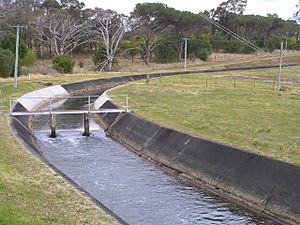
Upper Canal at Bringelly Road
|
|
| Location | |
| Country | Australia |
| State | New South Wales |
| Coordinates | 33°54′56″S 150°49′43″E / 33.9155°S 150.82863°E |
| General direction | South-west – North-east |
| From | Pheasants Nest |
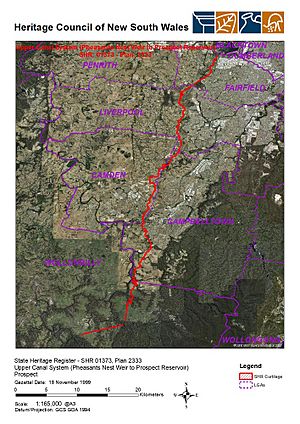
| Passes through | Wollondilly, Camden, Campbelltown, Liverpool, Fairfield, and Cumberland |
| To | Prospect Reservoir |
| General information | |
| Type | Water |
| Status | Operational |
| Owner | WaterNSW |
| Operator | Sydney Catchment Authority |
| Construction started | c. 1880 |
| Commissioned | 1888 |
| Technical information | |
| Length | 54 km (34 mi) |
| No. of compressor stations | Nil |
| No. of pumping stations | Nil |
| Designations | |
|---|---|
| Official name | Upper Canal System (Pheasants Nest Weir to Prospect Reservoir) |
| Type | Built |
| Criteria | a., b., e., f. |
| Designated | 18 November 1999 |
| Part of | Utilities - Water group |
| Reference no. | 01373 |
The Upper Canal System is a special water pathway that helps bring drinking water to Sydney, New South Wales, Australia. It's also known as the Southern Railway Aqueduct or the Cataract Tunnel. This system uses gravity to move water, meaning the water flows downhill naturally.
It includes about 54 kilometers (34 miles) of open canals, tunnels, and closed pipelines. These parts connect the Upper Nepean Scheme to the Prospect Reservoir. The Sydney Catchment Authority manages this important system for WaterNSW. Because it's so important and old, it's listed on the New South Wales State Heritage Register.
Contents
What is the Upper Canal System?
The Upper Canal is a big part of the Upper Nepean Scheme. This scheme collects water from the Cataract River and the Nepean River. The water then travels a long way to places like the Crown Street reservoir.
The Upper Canal starts with a tunnel at Pheasant's Nest Weir on the Nepean River. It then flows through several areas. These include Wollondilly, Camden, Campbelltown, Liverpool, Fairfield, and Cumberland. Finally, the water reaches the Prospect Reservoir.
How Water Flows
The canal system is designed to use gravity. This means the water flows downhill on its own. Over its 54-kilometer (34-mile) path, the water drops only about 50 meters (164 feet). This is a very gentle slope, making it easy for water to move without pumps.
How the Canal is Built
The Upper Canal is built from different materials. The choice of material depends on the ground it passes through.
- Where the ground is soft, the canal is shaped like a trapezoid. Its sides are lined with concrete slabs.
- In other areas, the canal is U-shaped. Here, the sides are lined with sandstone blocks.
- If the canal is cut into solid rock, it doesn't need any lining.
Tunnels help the water system go under hills. These tunnels are unlined if they go through solid rock. If they go through softer ground, they are lined with brick or sandstone.
Pipelines are used to cross creeks and valleys. These were originally iron pipes that rested on sandstone supports. The Upper Canal has about 1 kilometer (0.6 miles) of pipelines. These cross nine creeks and the Main Southern railway line. The system also has 19 kilometers (12 miles) of tunnels. The rest, about 44 kilometers (27 miles), is open canal.
Many of the original iron pipes are still used today. Some have plastic linings inside to protect them and keep them waterproof. The old ways of controlling water flow are also still in use. These include things like stop logs, penstocks, and gate valves.
In recent years, new water control systems have been added. These help manage water levels and handle different amounts of water flowing through.
How Much Water It Supplies
The Upper Nepean System, including the Upper Canal, is very important for Sydney. It provides about 20 to 40 percent of Sydney's daily drinking water.
History of the Canal
In 1867, leaders in New South Wales wanted a better water supply for Sydney. By 1869, they decided to build the Upper Nepean Scheme. This plan included two weirs (small dams) at Pheasant's Nest and Broughton's Pass. These weirs would send water into a series of tunnels, canals, and aqueducts. This whole system became known as the Upper Canal.
The goal was for water to flow by gravity from the collection areas to a reservoir at Prospect. This was Sydney's fourth major water supply system. Before this, Sydney used the Tank Stream, Busby's Bore, and the Botany Swamps.
Today, the Sydney Catchment Authority manages the Upper Canal. It is divided into eleven sections for easy maintenance. In the past, each section had its own keeper. These keepers lived in cottages built along the canal.
Why the Canal is Important (Heritage Listing)
The Upper Canal System is very important to the history of New South Wales. It was added to the New South Wales State Heritage Register on November 18, 1999.
It's important because:
- It's a main part of the Upper Nepean Scheme.
- It has been a key source of Sydney's water since 1888.
- It hasn't changed much over the years, except for maintenance.
- It shows how engineers like Edward Moriarty designed water systems in the 1800s.
- The canal looks beautiful as it winds through the countryside.
- It's a great example of 19th-century water engineering. It shows how gravity was used to move water.
 | Audre Lorde |
 | John Berry Meachum |
 | Ferdinand Lee Barnett |


