Upper Egypt facts for kids
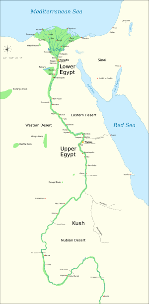
Upper Egypt was a long, narrow part of ancient Egypt. It stretched along both sides of the Nile River, from what is now Aswan in the south to just south of modern-day Cairo. A section in the middle, between El-Aiyat and Asyut, was sometimes called Middle Egypt.
Contents
What Was Upper Egypt Like?
Upper Egypt was known as Ta Shemau, which means "the land of reeds." This name likely came from the many plants that grew along the Nile in this area.
Districts of Upper Egypt
Upper Egypt was divided into twenty-two smaller areas called nomes. Each nome had its own capital city and local ruler. The first nome was near where Aswan is today. The twenty-second nome was located near modern Atfih, which was called Aphroditopolis in ancient times.
The Capital City
For most of ancient Egypt's long history, the city of Thebes was the main administrative center for Upper Egypt. It was a very important city for both government and religion.
Symbols of Upper Egypt
Upper Egypt had its own special symbols. Its crown was the tall, white crown called the Hedjet. This crown represented the power and rule over Upper Egypt. The flowering lotus plant was another important symbol for this region.
Related Pages
Images for kids
See also
 In Spanish: Alto Egipto para niños
 | George Robert Carruthers |
 | Patricia Bath |
 | Jan Ernst Matzeliger |
 | Alexander Miles |


