Ury, West Virginia facts for kids
Quick facts for kids
Ury, West Virginia
|
|
|---|---|

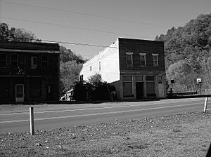
Ury West Virginia along Route 16
|
|
| Country | United States |
| State | West Virginia |
| County | Raleigh |
| Elevation | 1,683 ft (513 m) |
| Time zone | UTC-5 (Eastern (EST)) |
| • Summer (DST) | UTC-4 (EDT) |
| ZIP codes |
25937
|
| Area code(s) | 304 & 681 |
| GNIS feature ID | 1555864 |
Ury is a small, quiet place in Raleigh County, West Virginia, United States. It is known as an unincorporated community. This means it does not have its own local government like a city or town does. Instead, it is part of the larger county area.
Contents
Exploring Ury, West Virginia
Ury is located in the beautiful state of West Virginia. It sits along West Virginia Route 16 and near a place called Winding Gulf. This community is about 3 miles (5 km) north of another small place called Rhodell.
What is an Unincorporated Community?
An unincorporated community like Ury is a group of homes or buildings that are not officially part of a city or town. They do not have a mayor or a city council. Services like roads and police are usually managed by the county government.
Ury's Connection to Coal
Ury is also known as a coal town. Many communities in West Virginia grew because of the coal mining industry. Coal towns were often built near coal mines to house the miners and their families.
These towns played a big role in West Virginia's history. They helped power homes and factories across the country. Life in a coal town was often centered around the mine.
Geography and Location
Ury is nestled in the Appalachian Mountains. The area is known for its green hills and valleys. The elevation of Ury is about 1,683 feet (513 meters) above sea level.
The coordinates for Ury are 37°39′13″N 81°18′54″W. This helps people find its exact spot on a map. The community uses the Eastern Time Zone.
 | Chris Smalls |
 | Fred Hampton |
 | Ralph Abernathy |


