
Valeria, Iowa facts for kids
Quick facts for kids
Valeria, Iowa
|
|
|---|---|

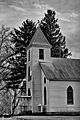
Sacred Heart Church
|
|

Location of Valeria, Iowa
|
|
| Country | |
| State | |
| County | Jasper |
| Area | |
| • Total | 0.05 sq mi (0.13 km2) |
| • Land | 0.05 sq mi (0.13 km2) |
| • Water | 0.00 sq mi (0.00 km2) |
| Elevation | 876 ft (267 m) |
| Population
(2020)
|
|
| • Total | 39 |
| • Density | 795.92/sq mi (305.95/km2) |
| Time zone | UTC-6 (Central (CST)) |
| • Summer (DST) | UTC-5 (CDT) |
| ZIP code |
50054
|
| Area code(s) | 515 |
| FIPS code | 19-80175 |
| GNIS feature ID | 0462514 |
Valeria is a small city located in Jasper County, Iowa, in the United States. It's a quiet place, and in 2020, only 39 people lived there.
Contents
History of Valeria
Valeria began its story in 1883. This happened after the Chicago Great Western Railway built its tracks through the area. The railway helped the town grow.
In 1887, about 100 people lived in Valeria. By 1902, the population grew to 146 residents. However, by 1915, the number of people living there had decreased to 92.
Geography of Valeria
Valeria is located in the state of Iowa. Its exact position on a map can be found using coordinates: 41.730538 degrees north and -93.324695 degrees west.
The United States Census Bureau says that Valeria covers a total area of about 0.13 square kilometers (or 0.05 square miles). All of this area is land, meaning there are no large lakes or rivers within the city limits.
People of Valeria
| Historical populations | ||
|---|---|---|
| Year | Pop. | ±% |
| 1920 | 70 | — |
| 1930 | 57 | −18.6% |
| 1940 | 79 | +38.6% |
| 1950 | 57 | −27.8% |
| 1960 | 76 | +33.3% |
| 1970 | 96 | +26.3% |
| 1980 | 80 | −16.7% |
| 1990 | 69 | −13.7% |
| 2000 | 62 | −10.1% |
| 2010 | 57 | −8.1% |
| 2020 | 39 | −31.6% |
| Source: and Iowa Data Center Source: |
||
Valeria's Population in 2020
According to the census from 2020, 39 people lived in Valeria. There were 15 households, which are groups of people living together in one home. Out of these, 10 were families.
Most people in Valeria (92.3%) were White. A small number (5.1%) were Asian, and 2.6% were of two or more races. About 2.6% of the population identified as Hispanic or Latino.
In terms of households, 33.3% had children under 18 living with them. More than half (53.3%) were married couples. Some households (33.3%) were not families, meaning individuals lived alone or with roommates.
The average age in Valeria was 47.3 years. About 15.4% of residents were under 20 years old. Most residents (51.3%) were between 45 and 64 years old. The city had slightly more males (51.3%) than females (48.7%).
Valeria's Population in 2010
In the census from 2010, there were 57 people living in Valeria. There were 22 households and 14 families.
Most residents (96.5%) were White, and 3.5% were African American.
About 22.7% of households had children under 18. Many households (54.5%) were married couples living together. The average household had 2.59 people.
The average age in the city was 43.5 years. About 26.3% of residents were under 18. Most people were between 45 and 64 years old (28.1%). The city had more males (56.1%) than females (43.9%).
Education in Valeria
Students in Valeria attend public schools operated by the Colfax–Mingo Community School District. This school district was formed on July 1, 1985, when the Colfax and Mingo school districts joined together.
Images for kids
-
Sacred Heart Church
See also
 In Spanish: Valeria (Iowa) para niños
