Van Buren, Ohio facts for kids
Quick facts for kids
Van Buren, Ohio
|
|
|---|---|
|
Village
|
|

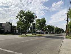
Main Street in Van Buren, Ohio
|
|

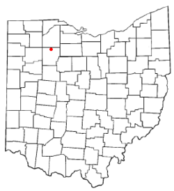
Location of Van Buren, Ohio
|
|

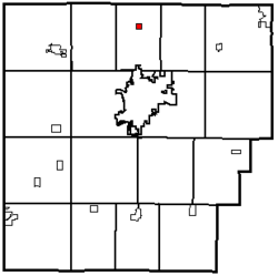
Location within Hancock County
|
|
| Country | United States |
| State | Ohio |
| County | Hancock |
| Government | |
| • Type | Village council |
| Area | |
| • Total | 0.26 sq mi (0.67 km2) |
| • Land | 0.26 sq mi (0.67 km2) |
| • Water | 0.00 sq mi (0.00 km2) |
| Elevation | 768 ft (234 m) |
| Population
(2020)
|
|
| • Total | 396 |
| • Density | 1,534.88/sq mi (593.39/km2) |
| Time zone | UTC-5 (Eastern (EST)) |
| • Summer (DST) | UTC-4 (EDT) |
| ZIP code |
45889
|
| Area code(s) | 419 |
| FIPS code | 39-79394 |
| GNIS feature ID | 2400043 |
Van Buren is a small village located in Hancock County, Ohio, in the United States. In 2020, a count of the population, called a census, showed that 396 people lived there.
Contents
Village History
Van Buren was first planned out in 1833. It was named after Martin Van Buren, who was the Vice President of the United States at that time (1833–1837). He later became the eighth President of the United States (1837–1841). The village officially became a village in 1866.
The very first school in Allen Township, where Van Buren is located, was built in 1836. It was a simple building made from round logs. Its roof was made of clapboard, and its windows were greased paper. There was a very large fireplace at one end to keep everyone warm.
Around 1870, a new school with two rooms was built from brick on East Market Street. This building was later found to be unsafe. So, a new four-room school was built. This school was used until 1917. That year, all the schools in Allen Township joined together. The current school, Van Buren High School, was then built.
A post office has been open in Van Buren since 1835. This means people have been sending and receiving mail there for a very long time!
Van Buren State Park
Van Buren is also home to the beautiful Van Buren State Park. This park started as a place to protect wildlife. In 1939, a dam was built on Rocky Ford Creek. This helped to improve the area for fish and other wildlife.
By 1950, the land became part of Ohio State Parks. It has been a much-loved state park ever since. Like the village, the park is also named after Martin Van Buren, the eighth President of the United States.
Long ago, the Shawnee people lived in the area around Van Buren State Park. The land here has many forests and good farmland. The park covers 296 acres. It is a quiet and peaceful place. People can visit all year round to enjoy activities like camping, fishing, hiking, horseback riding, and picnicking.
Where is Van Buren?
The United States Census Bureau says that Van Buren covers a total area of about 0.26 square miles (0.67 square kilometers). All of this area is land, with no large bodies of water inside the village limits.
Population Facts
| Historical population | |||
|---|---|---|---|
| Census | Pop. | %± | |
| 1840 | 74 | — | |
| 1850 | 122 | 64.9% | |
| 1870 | 157 | — | |
| 1880 | 130 | −17.2% | |
| 1890 | 268 | 106.2% | |
| 1900 | 367 | 36.9% | |
| 1910 | 303 | −17.4% | |
| 1920 | 273 | −9.9% | |
| 1930 | 279 | 2.2% | |
| 1940 | 307 | 10.0% | |
| 1950 | 308 | 0.3% | |
| 1960 | 374 | 21.4% | |
| 1970 | 319 | −14.7% | |
| 1980 | 342 | 7.2% | |
| 1990 | 337 | −1.5% | |
| 2000 | 313 | −7.1% | |
| 2010 | 328 | 4.8% | |
| 2020 | 396 | 20.7% | |
| U.S. Decennial Census | |||
The table above shows how the population of Van Buren has changed over many years. This information comes from the U.S. Decennial Census, which counts everyone in the United States every ten years.
What the 2010 Census Showed
In 2010, the census counted 328 people living in Van Buren. These people lived in 119 different homes, and 98 of these were families. The village had about 1261.5 people per square mile. There were 128 housing units in total.
Most of the people living in the village (97.3%) were White. A small number (1.8%) were from other racial groups, and 0.9% were from two or more races. About 4.3% of the population identified as Hispanic or Latino.
Out of the 119 homes, 41.2% had children under 18 living there. Most homes (64.7%) were married couples living together. About 10.9% of homes had a female head of household without a husband. Another 6.7% had a male head of household without a wife. About 17.6% of homes were not families.
About 14.3% of all homes had only one person living in them. And 4.2% of homes had someone living alone who was 65 years old or older. On average, there were 2.76 people in each home and 3.01 people in each family.
The average age of people in the village was 34.5 years old. About 30.5% of residents were under 18. Only 4.5% were between 18 and 24 years old. A larger group, 28.3%, was between 25 and 44. Another 23.8% were between 45 and 64. Finally, 12.8% of the people were 65 years old or older. The population was almost evenly split between males (49.7%) and females (50.3%).
See also
 In Spanish: Van Buren (Ohio) para niños
 | Calvin Brent |
 | Walter T. Bailey |
 | Martha Cassell Thompson |
 | Alberta Jeannette Cassell |

