Vassar, Michigan facts for kids
Quick facts for kids
Vassar, Michigan
|
|
|---|---|
| Nickname(s):
Cork Pine City, V-Town
|
|

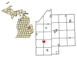
Location of Vassar, Michigan
|
|
| Country | United States |
| State | Michigan |
| County | Tuscola |
| Founded | 1 March 1849 |
| Area | |
| • Total | 2.20 sq mi (5.69 km2) |
| • Land | 2.15 sq mi (5.56 km2) |
| • Water | 0.05 sq mi (0.12 km2) |
| Elevation | 643 ft (196 m) |
| Population
(2020)
|
|
| • Total | 2,727 |
| • Density | 1,269.55/sq mi (490.07/km2) |
| Time zone | UTC-5 (Eastern (EST)) |
| • Summer (DST) | UTC-4 (EDT) |
| ZIP codes |
48768-48769
|
| Area code(s) | 989 |
| FIPS code | 26-81840 |
| GNIS feature ID | 1615523 |
Vassar is a city located in Tuscola County, in the state of Michigan in the United States. It was founded on March 1, 1849. In 2020, about 2,727 people lived there. The city is on the western edge of Vassar Township, but it runs its own government.
Contents
History of Vassar
Vassar was started by four men, including James M. Edmunds and Townsend North. They were looking for a good spot to build a dam and create a new town. The city was named after Edmunds' uncle, Matthew Vassar. He later started Vassar College, a famous school.
Vassar was once the main government center, or "county seat," for Tuscola County. But in 1860, the county seat moved to Caro. For the next 30 years, Vassar grew mostly because of its lumber industry. Many related businesses also opened there.
The settlement officially became a village in 1871. Vassar was an important spot for trains. Two major railway lines crossed there: the Michigan Central's Bay City Branch and the Port Huron & Northwestern line.
On September 28, 1944, the people living in the Village of Vassar voted to become a city. Then, on February 19, 1945, they approved the rules for how the new City of Vassar would be governed.
Geography of Vassar
Vassar covers about 2.18 square miles (5.69 square kilometers). Most of this area is land, with a small part being water. The Cass River flows right through the city.
Vassar is located in a part of Michigan often called "the Thumb" because of its shape on a map. This area is also part of the larger Flint/Tri-Cities region.
Population and People
| Historical population | |||
|---|---|---|---|
| Census | Pop. | %± | |
| 1880 | 670 | — | |
| 1890 | 1,682 | 151.0% | |
| 1900 | 1,832 | 8.9% | |
| 1910 | 1,659 | −9.4% | |
| 1920 | 1,453 | −12.4% | |
| 1930 | 1,816 | 25.0% | |
| 1940 | 2,154 | 18.6% | |
| 1950 | 2,530 | 17.5% | |
| 1960 | 2,680 | 5.9% | |
| 1970 | 2,802 | 4.6% | |
| 1980 | 2,727 | −2.7% | |
| 1990 | 2,559 | −6.2% | |
| 2000 | 2,823 | 10.3% | |
| 2010 | 2,697 | −4.5% | |
| 2020 | 2,727 | 1.1% | |
| U.S. Decennial Census | |||
How Many People Live Here?
In 2010, there were 2,697 people living in Vassar. These people made up 1,001 households and 668 families. The city had about 1,272 people per square mile.
Most of the people in Vassar were White (87.4%). About 8.8% were African American. A small number of people were Native American, Asian, or from other backgrounds. About 3% of the population was Hispanic or Latino.
About 35% of households had children under 18 living with them. Many households were married couples living together. Some households were led by a single parent. About 28% of households had just one person living there. The average household had about 2.47 people.
The average age of people in Vassar was 32.5 years old. About 31.6% of residents were under 18. About 11.8% were 65 years or older. The population was almost evenly split between males (49.8%) and females (50.2%).
Education in Vassar
Vassar has its own public school system. This includes:
- Vassar High School
- Vassar Junior High School
- Central Elementary School
- Townsend North Elementary School
There is also a private school called St. Luke's Lutheran School. It is a grade school that belongs to the Wisconsin Evangelical Lutheran Synod.
See also
 In Spanish: Vassar (Míchigan) para niños
 | Laphonza Butler |
 | Daisy Bates |
 | Elizabeth Piper Ensley |

