Verona, Kentucky facts for kids
Quick facts for kids
Verona, Kentucky
|
|
|---|---|
|
Census-designated place (CDP)
|
|

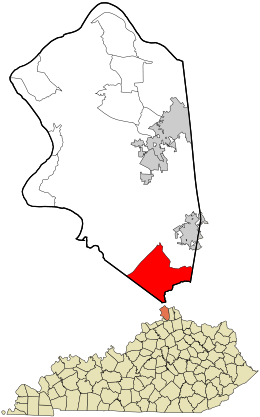
Location within Boone County and the state of Kentucky
|
|
| Country | United States |
| State | Kentucky |
| County | Boone |
| Area | |
| • Total | 12.33 sq mi (31.94 km2) |
| • Land | 12.24 sq mi (31.70 km2) |
| • Water | 0.09 sq mi (0.24 km2) |
| Elevation | 866 ft (264 m) |
| Population
(2020)
|
|
| • Total | 1,545 |
| • Density | 126.24/sq mi (48.74/km2) |
| Time zone | UTC-5 (Eastern (EST)) |
| • Summer (DST) | UTC-4 (EDT) |
| ZIP code |
41092
|
| Area code(s) | 859 |
| FIPS code | 21-79464 |
| GNIS feature ID | 2629699 |
Verona is a small community in Boone County, Kentucky, United States. It is known as a census-designated place (CDP). This means it's a place the government counts for population, but it doesn't have its own city government. In 2020, about 1,545 people lived there.
Contents
A Look at Verona's History
We don't know exactly when Verona was first settled. We also don't know who its first founders were. This information is not recorded in history books.
Verona's Early Days
Long ago, Verona was a busy place for businesses. It was surrounded by many farms. The community had stores for building supplies and groceries. There was also a blacksmith shop and a bank. People could buy dry goods and tobacco. There were even saloons and a barber shop. Verona had a funeral home, a jail, and a post office. The post office first opened on March 24, 1834.
Becoming a City
Verona officially became a city in 1909. However, its city government later stopped working. This happened because the community's leaders became inactive. So, Verona is no longer an official city.
Schools in the Area
The Walton-Verona independent school district started in 1954. This district serves students from both Verona and the nearby town of Walton. Verona has the elementary school for this district. Walton has the middle and high schools.
Where is Verona Located?
The Verona community is in the southern part of Boone County. It is near some important roads and county lines.
Borders and Roads
To the northwest, Interstate 71 runs along its border. To the southwest, it touches the line for Gallatin County. To the south, it borders Grant County. This southern border follows a creek called Bullock Pen Creek.
The main part of Verona is where two roads meet: Route 14 and Route 16. However, the area counted as Verona (the CDP) is much larger. It includes the rural areas around this main intersection.
Distances to Nearby Places
- It's about 6 miles (10 kilometers) northeast along Routes 14/16 to Walton.
- It's about 27 miles (43 kilometers) north to downtown Cincinnati.
Land and Water
The United States Census Bureau measures the size of places. They say Verona covers about 12.3 square miles (31.9 square kilometers). Most of this area is land, about 12.2 square miles (31.7 square kilometers). A small part, about 0.09 square miles (0.24 square kilometers), is water.
Who Lives in Verona?
| Historical population | |||
|---|---|---|---|
| Census | Pop. | %± | |
| 2020 | 1,545 | — | |
| U.S. Decennial Census | |||
The population of Verona was counted in the 2020 census. At that time, 1,545 people lived in the community.
See also
 In Spanish: Verona (Kentucky) para niños
 | Charles R. Drew |
 | Benjamin Banneker |
 | Jane C. Wright |
 | Roger Arliner Young |

