Gallatin County, Kentucky facts for kids
Quick facts for kids
Gallatin County
|
|
|---|---|

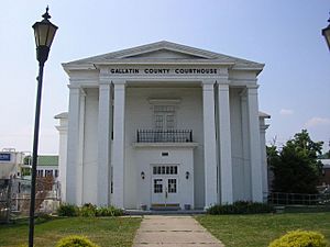
Gallatin County Courthouse in Warsaw
|
|

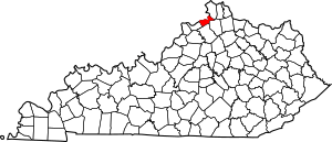
Location within the U.S. state of Kentucky
|
|
 Kentucky's location within the U.S. |
|
| Country | |
| State | |
| Founded | 1798 |
| Named for | Albert Gallatin |
| Seat | Warsaw |
| Largest city | Warsaw |
| Area | |
| • Total | 105 sq mi (270 km2) |
| • Land | 101 sq mi (260 km2) |
| • Water | 3.5 sq mi (9 km2) 3.3%% |
| Population
(2020)
|
|
| • Total | 8,690 |
| • Estimate
(2023)
|
8,792 |
| • Density | 82.8/sq mi (31.95/km2) |
| Time zone | UTC−5 (Eastern) |
| • Summer (DST) | UTC−4 (EDT) |
| Congressional district | 4th |
Gallatin County is a place in the northern part of Kentucky, a state in the United States. Its main town, or county seat, is Warsaw. The county was started in 1798. It was named after Albert Gallatin, who was an important government official called the Secretary of the Treasury under President Thomas Jefferson. Gallatin County is part of the larger Cincinnati metropolitan area, and it sits right along the Ohio River, across from the state of Indiana.
Contents
History of Gallatin County
Gallatin County was officially formed on December 14, 1798. It was the 31st county created in Kentucky. It was made from parts of Franklin and Shelby counties. Over time, parts of Gallatin County were used to create three more counties: Owen in 1819, Trimble in 1836, and Carroll in 1838. Today, Gallatin County is much smaller than it was originally. Its northern edge is the Ohio River.
In 1800, about 1,291 people lived in Gallatin County. This included 960 white people, 329 enslaved people, and 2 free people of color.
During the American Civil War, which was a big conflict in the United States, some small battles happened in Gallatin County. Some men were arrested because they supported the Confederates.
After the Civil War, in 1866, a sad event called the Gallatin County Race Riot took place. During this time, groups of people caused trouble and unfairness. Many African American people were forced to leave their homes and cross the Ohio River.
A terrible accident happened on December 4, 1868, on the Ohio River near Warsaw. Two large passenger boats, the America and the United States, crashed into each other. The United States was carrying barrels of kerosene, which quickly caught fire. The fire spread to the America. Many passengers died from the fire or by drowning. In total, 162 people lost their lives, making it one of the worst steamboat accidents in American history.
As the 1900s went on, river trade by steamboat became less common. Faster ways to travel and move goods became popular, like trains, cars, trucks, and airplanes. Construction on the Markland Locks and Dam started in 1956 and finished in 1964. In 1967, a power plant was built at the dam that uses water to make electricity, which created jobs for people. Today, major roads like Interstate 71, U.S. Route 42, and U.S. Route 127 cross through Gallatin County. By the 1980s, more than half of the people living in the county worked in other areas.

Geography of Gallatin County
Gallatin County covers a total area of about 105 square miles (272 square kilometers). Most of this area, about 101 square miles (262 square kilometers), is land. The rest, about 3.5 square miles (9.1 square kilometers), is water. It is the second smallest county in Kentucky by land area.
Counties Nearby
Gallatin County shares its borders with several other counties:
- Switzerland County, Indiana (to the north)
- Boone County (to the northeast)
- Grant County (to the southeast)
- Owen County (to the south)
- Carroll County (to the west)
People of Gallatin County (Demographics)
| Historical population | |||
|---|---|---|---|
| Census | Pop. | %± | |
| 1800 | 1,291 | — | |
| 1810 | 3,307 | 156.2% | |
| 1820 | 7,075 | 113.9% | |
| 1830 | 6,674 | −5.7% | |
| 1840 | 4,003 | −40.0% | |
| 1850 | 5,137 | 28.3% | |
| 1860 | 5,056 | −1.6% | |
| 1870 | 5,074 | 0.4% | |
| 1880 | 4,832 | −4.8% | |
| 1890 | 4,611 | −4.6% | |
| 1900 | 5,163 | 12.0% | |
| 1910 | 4,697 | −9.0% | |
| 1920 | 4,664 | −0.7% | |
| 1930 | 4,437 | −4.9% | |
| 1940 | 4,307 | −2.9% | |
| 1950 | 3,969 | −7.8% | |
| 1960 | 3,867 | −2.6% | |
| 1970 | 4,134 | 6.9% | |
| 1980 | 4,842 | 17.1% | |
| 1990 | 5,393 | 11.4% | |
| 2000 | 7,870 | 45.9% | |
| 2010 | 8,589 | 9.1% | |
| 2020 | 8,690 | 1.2% | |
| 2023 (est.) | 8,792 | 2.4% | |
| U.S. Decennial Census 1790–1960 1900–1990 1990–2000 2010–2021 |
|||
In 2010, there were 8,589 people living in Gallatin County. Most residents were White (94.7%), with smaller groups of Black or African American (1.3%), Asian (0.2%), and Native American (0.1%) people. About 4.3% of the population was Hispanic or Latino. Many people in the county have German, American, Irish, or English family backgrounds.
In 2000, the county had 7,870 people. The population density was about 80 people for every square mile. There were 2,902 households, and 2,135 of these were families. The average household had about 2.68 people.
About 28.6% of the population was under 18 years old. The median age in the county was 35 years. This means half the people were younger than 35 and half were older.
Towns and Communities
Here are the main communities in Gallatin County:
Transportation and Buildings
Getting Around
Interstate 71 is a major highway that goes through Gallatin County. It has three exits near the towns of Sparta and Glencoe. For public transportation, Senior Services of Northern Kentucky offers a special service where you can call to arrange a ride.
Airport
Ideas for building an airport in Gallatin County started in 2004. Money for the airport was officially approved by federal, state, and local governments in 2019. The airport officially opened in June 2023. Its special code for flights is 8GK.
Famous People from Gallatin County
- Samuel Brenton (1810–1857): He was born in Gallatin County, Kentucky, and later became a US Representative for the state of Indiana.
- John Taylor (Baptist preacher): He was a well-known preacher and historian in the early days of the frontier. He owned large farms in the county where enslaved people worked.
See also
 In Spanish: Condado de Gallatin (Kentucky) para niños
 | James Van Der Zee |
 | Alma Thomas |
 | Ellis Wilson |
 | Margaret Taylor-Burroughs |

