Vilare Island facts for kids

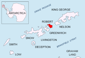
Location of Robert Island in the South Shetland Islands
|
|
|
Location of Vilare Island
|
|
| Geography | |
|---|---|
| Location | Antarctica |
| Coordinates | 62°21′06.5″S 59°40′35″W / 62.351806°S 59.67639°W |
| Archipelago | South Shetland Islands |
| Administration | |
| Administered under the Antarctic Treaty System | |
| Demographics | |
| Population | uninhabited |
Vilare Island (which means ostrov Vilare in Bulgarian) is a small island located near the huge continent of Antarctica. It's part of a group of islands called the Onogur Islands, which are found off the northwest coast of Robert Island. This island is quite small, only about 130 meters long from east to west and 60 meters wide.
Vilare Island is special because it's mostly free of ice, which is unusual for an island in Antarctica! It's also separated from another island, Churicheni Island, by a narrow passage that's only 20 meters wide. The island gets its name from a place called Vilare in Northern Bulgaria.
Where is Vilare Island Located?
Vilare Island is found at specific coordinates: 62 degrees, 21 minutes, 6.5 seconds South, and 59 degrees, 40 minutes, 35 seconds West. To help you imagine its spot, it's about 1.7 kilometers (just over a mile) north-northeast of a place called Misnomer Point. It's also 290 meters (about 950 feet) west-southwest of Shipot Point.
Bulgarian explorers and mapmakers officially mapped this island in 2009. This helps scientists and adventurers know exactly where it is in the vast Antarctic region.
Exploring Maps of the Area
Maps are super important for understanding geography, especially in remote places like Antarctica. One helpful map for this region is:
- L.L. Ivanov. Antarctica: Livingston Island and Greenwich, Robert, Snow and Smith Islands. This is a detailed topographic map, meaning it shows the shape and features of the land. It was created in 2009 by the Manfred Wörner Foundation.
 | Isaac Myers |
 | D. Hamilton Jackson |
 | A. Philip Randolph |


