Vine Hill, California facts for kids
Quick facts for kids
Vine Hill
|
|
|---|---|

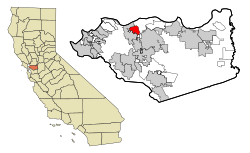
Location in Contra Costa County and the state of California
|
|
| Country | |
| State | |
| County | Contra Costa |
| Area | |
| • Total | 1.504 sq mi (3.894 km2) |
| • Land | 1.504 sq mi (3.894 km2) |
| • Water | 0 sq mi (0 km2) |
| Elevation | 30 ft (9 m) |
| Population
(2010)
|
|
| • Total | 3,761 |
| • Density | 2,500.7/sq mi (965.84/km2) |
| Time zone | UTC-8 (PST) |
| • Summer (DST) | UTC-7 (PDT) |
| ZIP code |
94553
|
| Area code(s) | 925 |
| FIPS code | 06-82842 |
| GNIS feature IDs | 1652648, 2409517 |
Vine Hill is a community in Contra Costa County, California, United States. It's called a "census-designated place" (CDP) because it's a special area the government uses to collect information about people. In 2010, about 3,761 people lived there. Vine Hill is located about 2.25 miles (3.6 km) east of Martinez.
Contents
Geography of Vine Hill
Vine Hill covers a total area of about 1.5 square miles (3.89 square kilometers). All of this area is land, meaning there are no large lakes or rivers within its borders.
Population and People
Vine Hill has grown over the years. Here's how its population has changed:
| Historical population | |||
|---|---|---|---|
| Census | Pop. | %± | |
| 1990 | 3,214 | — | |
| 2000 | 3,260 | 1.4% | |
| 2010 | 3,761 | 15.4% | |
| sources:; | |||
Vine Hill in 2010
In 2010, the population of Vine Hill was 3,761 people. This means there were about 2,501 people living in every square mile.
Most people in Vine Hill were White (68.3%). Other groups included African American (3.0%), Asian (5.2%), and Native American (0.9%). About 14.9% of the people were from other backgrounds, and 6.8% identified with two or more groups. A significant portion, 31.1%, were of Hispanic or Latino origin.
Almost everyone (98.9%) lived in regular homes. Only a small number (1.1%) lived in group housing that wasn't like a typical home.
There were 1,264 households in Vine Hill. About 40.3% of these homes had children under 18 living there. Many homes (49.8%) were married couples. Some homes had a single parent, with 15.2% having a female head of household and 7.6% having a male head of household.
The average household had about 2.94 people. The average family size was 3.30 people.
The population included people of all ages. About 24.1% were under 18 years old. Young adults aged 18 to 24 made up 9.2% of the population. The largest group, 31.7%, was aged 25 to 44. People aged 45 to 64 made up 26.2%, and 8.9% were 65 or older. The average age in Vine Hill was 35.1 years.
Most homes (65.9%) were owned by the people living in them. The rest (34.1%) were rented. This means 63.3% of the population lived in homes they owned, and 35.5% lived in rented homes.
Vine Hill in 2000
In 2000, Vine Hill had 3,260 people. There were about 697 people per square mile.
The racial makeup was similar to 2010, with 75.09% White. Other groups included African American (2.24%), Native American (1.72%), and Asian (2.27%). About 24.14% of the population was Hispanic or Latino.
There were 1,144 households. About 36.3% of these had children under 18. Many (49.0%) were married couples.
The median income for a household was $48,125. This means half of the households earned more than this amount, and half earned less. For families, the median income was $53,750. The average income per person was $17,985.
About 6.6% of the population lived below the poverty line. This included 5.6% of children under 18 and 9.6% of people aged 65 or older.
Education in Vine Hill
Most students in Vine Hill attend schools in the Martinez Unified School District. A smaller part of the community is served by the Mount Diablo Unified School District.
See also
In Spanish: Vine Hill (California) para niños
 | Percy Lavon Julian |
 | Katherine Johnson |
 | George Washington Carver |
 | Annie Easley |


