Viti Levu facts for kids
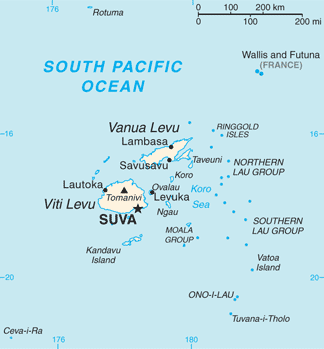
Map of Fiji showing Viti Levu (one of its major islands)
|
|
 |
|
| Geography | |
|---|---|
| Location | Pacific Ocean |
| Coordinates | 17°48′S 178°0′E / 17.800°S 178.000°E |
| Archipelago | Viti Levu Group |
| Area | 10,388 km2 (4,011 sq mi) |
| Area rank | 75th |
| Length | 146 km (90.7 mi) |
| Width | 106 km (65.9 mi) |
| Highest elevation | 1,324 m (4,344 ft) |
| Highest point | Tomanivi |
| Administration | |
|
Fiji
|
|
| Division | Western Division and Central Division |
| Largest settlement | Suva (pop. 93,970) |
| Demographics | |
| Population | 740,000 (2022) |
| Pop. density | 55.83 /km2 (144.6 /sq mi) |
| Ethnic groups | Native Fijians (54.3%), Indo-Fijians (38.1%); other (Asian, Europeans, other Pacific Islander) (7.6%) |
Viti Levu (pronounced like "Vee-chee Leh-voo") means "Great Fiji." It is the largest island in the country of Fiji. The capital city, Suva, is located here. Most of Fiji's people live on Viti Levu.
Contents
How Viti Levu Was Formed
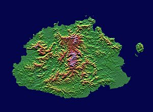
Viti Levu is in a special area where Earth's giant plates, called tectonic plates, meet. These plates are always moving. This movement causes things like earthquakes and volcanoes.
Long ago, volcanic eruptions helped create the island. The oldest rocks on Viti Levu are from these ancient volcanoes. Over time, these powerful forces shaped the island. They created its mountains and rugged land.
Island Geography and Nature
Viti Levu is the biggest island in Fiji. About 70% of Fiji's population, which is around 600,000 people, live here. The island is about 146 kilometers (91 miles) long and 106 kilometers (66 miles) wide. Its total area is about 10,389 square kilometers (4,011 square miles).
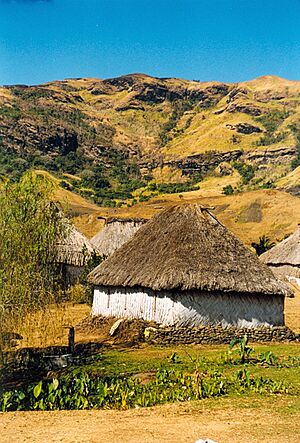
The island has a mountain range running from north to south. This range divides the island into two main parts. The middle of the island is covered in forests. It is home to Fiji's highest mountain, Mount Tomanivi, which is 1,324 meters (4,344 feet) tall.
Climate and Ecosystems
The eastern side of Viti Levu gets a lot of rain. This is especially true in the mountains. This area has tropical moist forests. The western side of the island is much drier. It is in the "rain shadow" of the mountains. This means the mountains block the rain. This side has tropical dry forests. People sometimes call it the "burning west."
Farming and Wildlife
Because of the different climates, different types of farming happen on the island. Sugar cane grows well in the drier west. A dairy industry is growing in the wetter east. Fiji's largest cattle ranch is in Yaqara. It has 7,000 cattle on 70 square kilometers (27 square miles) of land.
Viti Levu is also the only place in the world where you can find the Giant Fijian long-horned beetle. This is one of the largest insects on Earth.
Climate Change Effects
Viti Levu is at risk from climate change. Rising sea levels and strong storms could affect the island. It is thought that many people, especially in the northern and western parts, might need to move in the future.
Towns and Cities
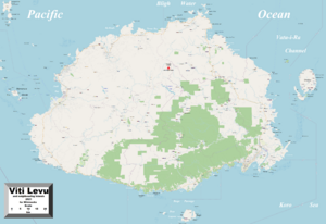
Viti Levu is home to Suva, the capital city. Almost three-quarters of Fiji's people live on this island. Other important towns and cities are along the coast. These include Ba, Lautoka, Nadi, Nausori, Rakiraki, and Sigatoka.
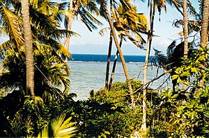
Two other popular places are Natadola Beach and Pacific Harbour. Natadola Beach has fancy resorts. Pacific Harbour is a resort area about 50 kilometers (31 miles) from Suva. A single main road goes all the way around Viti Levu.
How the Island is Governed
Viti Levu has eight of Fiji's fourteen Provinces. Provinces are like states or regions. The provinces of Ba, Nadroga-Navosa, and Ra are in the Western Division. The provinces of Naitasiri, Namosi, Rewa, Serua, and Tailevu make up the Central Division.
The way politics works is a bit different in the west compared to the east. This is partly because many Indo-Fijians live in western Viti Levu. Their ancestors came from India to work there a long time ago. Most native Fijians live in eastern Viti Levu, except in the cities, which have a mix of people.
Island History
People believe that Viti Levu has been lived on for a longer time than the island of Vanua Levu. Vanua Levu is to the north. Old stories say that the first settlers from Melanesia landed at Vuda Point. They then started Viseisei, which is said to be Fiji's oldest settlement.
Getting Around Viti Levu
You can travel to other islands from Viti Levu by ferry. The Patterson Brothers Shipping Company LTD provides this service.
Nausori International Airport is also on Viti Levu. It has flights from three different airlines that travel within Fiji.
 | John T. Biggers |
 | Thomas Blackshear |
 | Mark Bradford |
 | Beverly Buchanan |


