Wagon Bed Spring (Kansas) facts for kids
|
Lower Cimarron Spring
|
|

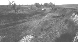
View of the spring site
|
|
| Nearest city | Ulysses, Kansas |
|---|---|
| Area | 195 acres (79 ha) (after 1998 enlargement) |
| Built | 1820 |
| NRHP reference No. | 66000344 |
Quick facts for kids Significant dates |
|
| Added to NRHP | October 15, 1966 |
| Boundary increase | August 5, 1998 |
| Designated NHL | December 19, 1960 |
Wagon Bed Spring, also known as the Lower Spring or Lower Cimarron Spring, is a historic former spring in Grant County, Kansas, United States. It is located about 12 miles (19 km) south of Ulysses. In the 1800s, this spring was a very important place for travelers on the Santa Fe Trail. It was a key watering spot on the Cimarron Cutoff, where many people often camped. Today, the spring is dry. This happened mainly because irrigation nearby lowered the water level underground. In 1961, it was named a National Historic Landmark.
Contents
Wagon Bed Spring: A Historic Stop on the Santa Fe Trail
Wagon Bed Spring is found near what used to be the north bank of the Cimarron River. It is in a rural area about 12 miles (19 km) south of Ulysses, Kansas. Signs are at the site to help visitors understand its history.
The Cimarron River has not always flowed with water. Its path has changed over time due to floods. The spring itself is now in the river bed. The water for the spring came from a large underground water source called the Ogallala Aquifer.
Why Was This Spring So Important?
This site is very important for history and archaeology. It was a major camping spot for travelers on the Santa Fe Trail. The spring was one of the few places to find reliable water on the Cimarron Cutoff. This part of the trail was between the Arkansas and Cimarron Rivers. Many groups of travelers and soldiers camped here for about 60 years while the trail was used.
In 1907, a group called the Daughters of the American Revolution placed a historic marker near the spring. This marker helped people remember the spring's importance.
The Spring Dries Up
Starting in 1914, floods on the Cimarron River began to change the land around the spring. These floods eventually moved the spring's location into a much wider river bed.
Sadly, the spring stopped flowing in the 1960s. This happened because of Center pivot irrigation nearby. This type of farming uses a lot of water, which lowered the underground water table. When the water table dropped, the spring could no longer flow.
Protecting History: A National Landmark
The site was named a National Historic Landmark in 1960. This means it is a place of national historical importance. For a while, the exact boundaries of the site were not clear. Also, not much archaeological study had been done there.
In the early 1990s, the National Park Service began formal studies. These studies helped to map out the spring area. They also found the main areas where travelers used to camp. The landmark area now includes parts of the old wagon ruts, which are tracks left by the wagons.
 | Georgia Louise Harris Brown |
 | Julian Abele |
 | Norma Merrick Sklarek |
 | William Sidney Pittman |


