Wagon Mound National Historic Landmark facts for kids
|
Wagon Mound
|
|
 |
|
| Nearest city | Wagon Mound, New Mexico |
|---|---|
| Area | 150 acres (61 ha) |
| Built | 1868 |
| NRHP reference No. | 66000478 |
Quick facts for kids Significant dates |
|
| Added to NRHP | October 15, 1966 |
| Designated NHL | May 23, 1963 |
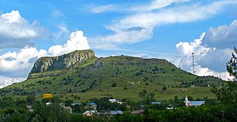
The Wagon Mound is a special butte (a tall, flat-topped hill with steep sides) that was a very important landmark. It helped pioneers find their way along the Cimarron Cutoff. This was a famous route that connected St. Louis, Missouri, to Santa Fe, New Mexico.
You can find Wagon Mound just east of the village of Wagon Mound, New Mexico. The village was actually named after this very butte! Wagon Mound is so important that it's now a National Historic Landmark. Another nearby historic spot, Santa Clara Canyon, is also part of this landmark. Travelers often camped there and found water.
Contents
What is Wagon Mound?
Wagon Mound is a type of mesa, which is like a large, flat-topped hill. It looks a bit like a diamond shape from above. Its highest point reaches about 6,930 feet (2,112 meters) into the sky.
Where is Wagon Mound Located?
If you travel east from the village of Wagon Mound, you'll find New Mexico State Road 120 running north of the mesa. New Mexico State Road 271 goes southeast from the village, passing to the south and west of the mesa. The village itself is right to the west of Wagon Mound. There are also two smaller mesas nearby called the Pilot Knobs. Wagon Mound is easy to see from another famous landmark, the Rabbit Ears, which are further east on the trail.
Why Was Wagon Mound Important?
Wagon Mound was a super important spot on the Cimarron Cutoff part of the Santa Fe Trail. It helped travelers in a few big ways.
A Sign of the End of the Journey
First, for people traveling west, Wagon Mound was the last major landmark they would see before reaching Santa Fe. It was a welcome sight, telling them their long journey was almost over!
Water and Safety Along the Trail
Second, about 2 miles (3.2 km) northwest of Wagon Mound was Santa Clara Canyon. This canyon had a spring that provided a reliable source of water. This was super important in the dry desert environment. However, Santa Clara Canyon also served as a warning. The way the land was shaped there made groups camping vulnerable to conflicts with local Native American groups. One big conflict happened in 1850.
The End of an Era
The Santa Fe Trail, and places like Wagon Mound, were used a lot between about 1822 and the American Civil War. But things changed in the 1870s. When the railroad arrived, it followed much of the same route as the Santa Fe Trail. This meant fewer people needed to travel by wagon, and the use of the trail slowly declined.


