Wakefield, Virginia facts for kids
Quick facts for kids
Wakefield, Virginia
|
|
|---|---|

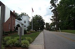
West Church Street at Main Street in Wakefield
|
|

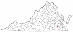
Location of Wakefield, Virginia
|
|
| Country | United States |
| State | Virginia |
| County | Sussex |
| Area | |
| • Total | 1.29 sq mi (3.33 km2) |
| • Land | 1.25 sq mi (3.22 km2) |
| • Water | 0.04 sq mi (0.10 km2) |
| Elevation | 98 ft (30 m) |
| Population
(2020)
|
|
| • Total | 759 |
| • Density | 588.4/sq mi (227.9/km2) |
| Time zone | UTC−5 (Eastern (EST)) |
| • Summer (DST) | UTC−4 (EDT) |
| ZIP code |
23888
|
| Area code(s) | 757, 948 |
| FIPS code | 51-82384 |
| GNIS feature ID | 1496365 |
Wakefield is a small town located in Sussex County, Virginia, in the United States. In 2020, about 759 people lived there.
Wakefield is famous for a few cool places! You might know it for the Virginia Diner, which is a popular restaurant. There's also the Airfield Conference and 4-H Educational Center nearby, which is a great spot for learning and events. Even though the weather office and the 4-H center are just outside the town, they are still a big part of what makes Wakefield special.
The town also hosts the Virginia Shad Planking, which is a unique event.
Contents
Geography of Wakefield
Wakefield is located in a spot that's easy to find on a map, at 36°58′13″N 76°59′18″W / 36.970219°N 76.988461°W.
The town covers a total area of about 1.3 square miles (3.3 square kilometers). Most of this area, about 1.2 square miles (3.2 square kilometers), is land. A small part, about 0.04 square miles (0.1 square kilometers), is water.
Wakefield's Climate
The weather in Wakefield changes with the seasons, just like in many parts of Virginia. Here's a look at the typical weather conditions:
| Climate data for Wakefield 1 NW, Virginia (1991–2020 normals, extremes 1982–present) | |||||||||||||
|---|---|---|---|---|---|---|---|---|---|---|---|---|---|
| Month | Jan | Feb | Mar | Apr | May | Jun | Jul | Aug | Sep | Oct | Nov | Dec | Year |
| Record high °F (°C) | 82 (28) |
82 (28) |
89 (32) |
96 (36) |
97 (36) |
102 (39) |
105 (41) |
104 (40) |
105 (41) |
99 (37) |
84 (29) |
81 (27) |
105 (41) |
| Mean daily maximum °F (°C) | 49.8 (9.9) |
53.0 (11.7) |
61.1 (16.2) |
71.4 (21.9) |
78.6 (25.9) |
85.8 (29.9) |
89.7 (32.1) |
87.7 (30.9) |
81.8 (27.7) |
72.0 (22.2) |
62.0 (16.7) |
53.1 (11.7) |
70.5 (21.4) |
| Daily mean °F (°C) | 39.0 (3.9) |
41.5 (5.3) |
48.4 (9.1) |
58.3 (14.6) |
66.6 (19.2) |
74.5 (23.6) |
78.8 (26.0) |
77.0 (25.0) |
71.0 (21.7) |
60.0 (15.6) |
49.8 (9.9) |
42.3 (5.7) |
58.9 (14.9) |
| Mean daily minimum °F (°C) | 28.2 (−2.1) |
30.1 (−1.1) |
35.8 (2.1) |
45.2 (7.3) |
54.7 (12.6) |
63.3 (17.4) |
68.0 (20.0) |
66.3 (19.1) |
60.2 (15.7) |
48.0 (8.9) |
37.6 (3.1) |
31.4 (−0.3) |
47.4 (8.6) |
| Record low °F (°C) | −14 (−26) |
−4 (−20) |
12 (−11) |
22 (−6) |
30 (−1) |
43 (6) |
49 (9) |
46 (8) |
36 (2) |
27 (−3) |
16 (−9) |
2 (−17) |
−14 (−26) |
| Average precipitation inches (mm) | 3.83 (97) |
2.80 (71) |
4.22 (107) |
3.76 (96) |
4.15 (105) |
4.77 (121) |
5.47 (139) |
5.50 (140) |
6.05 (154) |
3.95 (100) |
3.17 (81) |
3.73 (95) |
51.40 (1,306) |
| Average snowfall inches (cm) | 3.5 (8.9) |
1.4 (3.6) |
0.4 (1.0) |
0.0 (0.0) |
0.0 (0.0) |
0.0 (0.0) |
0.0 (0.0) |
0.0 (0.0) |
0.0 (0.0) |
0.0 (0.0) |
0.0 (0.0) |
1.1 (2.8) |
6.4 (16) |
| Average precipitation days (≥ 0.01 in) | 10.3 | 9.3 | 11.3 | 10.2 | 11.0 | 10.6 | 11.2 | 10.4 | 9.4 | 8.3 | 8.2 | 10.9 | 121.1 |
| Average snowy days (≥ 0.1 in) | 1.4 | 1.0 | 0.6 | 0.1 | 0.0 | 0.0 | 0.0 | 0.0 | 0.0 | 0.0 | 0.1 | 0.6 | 3.8 |
| Source: NOAA | |||||||||||||
History of Wakefield
Wakefield has been around for a long time! Its name even shows up on an old map of Virginia called the Fry-Jefferson map, which was first made in 1752. This means the area has a rich history stretching back hundreds of years.
People of Wakefield
Understanding the demographics of a place means looking at who lives there. This includes things like how many people there are and their different backgrounds.
The number of people living in Wakefield has changed over the years:
| Historical population | |||
|---|---|---|---|
| Census | Pop. | %± | |
| 1910 | 570 | — | |
| 1920 | 784 | 37.5% | |
| 1930 | 881 | 12.4% | |
| 1940 | 687 | −22.0% | |
| 1950 | 949 | 38.1% | |
| 1960 | 1,015 | 7.0% | |
| 1970 | 942 | −7.2% | |
| 1980 | 1,355 | 43.8% | |
| 1990 | 1,070 | −21.0% | |
| 2000 | 1,038 | −3.0% | |
| 2010 | 927 | −10.7% | |
| 2020 | 759 | −18.1% | |
| U.S. Decennial Census 2010 2020 |
|||
Wakefield's Population in 2020
In 2020, the town of Wakefield had 759 residents. Here's a quick look at the different groups of people living there:
| Race / Ethnicity (NH = Non-Hispanic) | Pop 2010 | Pop 2020 | % 2010 | % 2020 |
|---|---|---|---|---|
| White alone (NH) | 427 | 347 | 46.06% | 45.72% |
| Black or African American alone (NH) | 469 | 345 | 50.59% | 45.45% |
| Native American or Alaska Native alone (NH) | 3 | 0 | 0.32% | 0.00% |
| Asian alone (NH) | 14 | 1 | 1.51% | 0.13% |
| Pacific Islander alone (NH) | 0 | 0 | 0.00% | 0.00% |
| Some Other Race alone (NH) | 0 | 8 | 0.00% | 1.05% |
| Mixed Race or Multi-Racial (NH) | 6 | 40 | 0.65% | 5.27% |
| Hispanic or Latino (any race) | 8 | 18 | 0.86% | 2.37% |
| Total | 927 | 759 | 100.00% | 100.00% |
Wakefield's Population in 2010
Back in 2010, there were 927 people living in Wakefield. At that time, about 50.6% of the people were Black, and 46.1% were White. Smaller groups included Native American, Asian, and people of two or more races. About 0.9% of the population was Hispanic or Latino.
In the year 2000, Wakefield had 1,038 people. The town had 423 households, which are groups of people living together in one home. The average household had about 2.45 people.
See also
 In Spanish: Wakefield (Virginia) para niños
 | Jessica Watkins |
 | Robert Henry Lawrence Jr. |
 | Mae Jemison |
 | Sian Proctor |
 | Guion Bluford |

