Wakefield, Fairfax County, Virginia facts for kids
Quick facts for kids
Wakefield, Fairfax County, Virginia
|
|
|---|---|

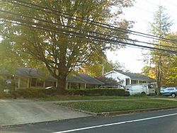
Houses on Wakefield Chapel Road, October 2016
|
|
| Country | |
| State | |
| County | |
| Area | |
| • Total | 3.80 sq mi (9.85 km2) |
| • Land | 3.77 sq mi (9.76 km2) |
| • Water | 0.03 sq mi (0.09 km2) |
| Elevation | 300 ft (90 m) |
| Population
(2010)
|
|
| • Total | 11,805 |
| • Density | 2,991/sq mi (1,154.7/km2) |
| Time zone | UTC−5 (Eastern (EST)) |
| • Summer (DST) | UTC−4 (EDT) |
| ZIP code |
22003
|
| FIPS code | 51-82371 |
| GNIS feature ID | 2584933 |
Wakefield is a special kind of community in Fairfax County, Virginia. It's called a census-designated place, or CDP. This means it's an area that looks like a town but isn't officially a city or village.
About 11,275 people lived here in 2010. Many of the homes in Wakefield were built between the 1950s and 1960s. It's a great place with parks and schools.
Contents
Exploring Wakefield's Location
Wakefield is located in a busy part of Virginia. It is surrounded by major roads. These include the Capital Beltway, Little River Turnpike, Guinea Road, and Braddock Road.
Key Landmarks and Features
The area gets its name from the historic Wakefield Chapel. This old Methodist church was built in 1899. Today, the county owns it, and you can still use it as a chapel. Wakefield Chapel Road runs right through the community.
You'll also find Wakefield Park Recreation Center here. Many neighborhoods in the area also share the Wakefield name. The Annandale Campus of Northern Virginia Community College is also located within Wakefield. Another important spot is the historic Oak Hill Mansion.
Neighboring Communities
Wakefield has many neighbors. To the northwest is Mantua. Woodburn is to the north. To the east, you'll find Annandale. North Springfield is southeast.
To the south are Ravensworth and Kings Park. Burke is southwest, and Long Branch is to the west. The city of Fairfax is about 3 miles west. Downtown Washington, D.C. is about 15 miles northeast.
Size and Area
The total area of Wakefield is about 9.85 square kilometers. Most of this area is land, about 9.76 square kilometers. A small part, about 0.09 square kilometers, is water.
Education in Wakefield
Students in Wakefield attend schools run by Fairfax County Public Schools. These public schools are within the community.
Local Public Schools
- Canterbury Woods Elementary School (has an Annandale postal address)
- Wakefield Forest Elementary School
Other Educational Facilities
Holy Spirit School is a private school in Wakefield. It is part of the Roman Catholic Diocese of Arlington. It also uses an Annandale postal address.
Northern Virginia Community College has its Annandale Campus here. This college offers many programs for students after high school.
 | Georgia Louise Harris Brown |
 | Julian Abele |
 | Norma Merrick Sklarek |
 | William Sidney Pittman |


