Wales Township, Michigan facts for kids
Quick facts for kids
Wales Township, Michigan
|
|
|---|---|

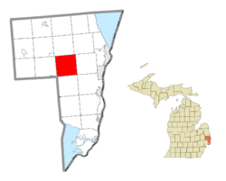
Location within St. Clair County
|
|
| Country | United States |
| State | Michigan |
| County | St. Clair |
| Organized | 1841 |
| Area | |
| • Total | 37.4 sq mi (96.8 km2) |
| • Land | 37.4 sq mi (96.7 km2) |
| • Water | 0.0 sq mi (0.1 km2) |
| Elevation | 702 ft (214 m) |
| Population
(2020)
|
|
| • Total | 3,180 |
| • Density | 85.03/sq mi (32.85/km2) |
| Time zone | UTC-5 (Eastern (EST)) |
| • Summer (DST) | UTC-4 (EDT) |
| ZIP code(s) |
48027
|
| Area code(s) | 810 |
| FIPS code | 26-82900 |
| GNIS feature ID | 1627207 |
Wales Township is a community located in St. Clair County, Michigan, in the United States. It is a type of local government area known as a civil township. In 2020, about 3,180 people lived here. The township was officially created in 1841.
Contents
Exploring Wales Township's Communities
Wales Township is home to several smaller, unincorporated communities. These are places where people live, but they don't have their own separate local government like a city or village.
Goodells: A Northern Hub
- Goodells is found in the northern part of the township. It's located where Goodells Road and Morris Road meet. This community started in 1866 when the Grand Trunk Railroad built a train line and opened a station. A post office opened here in November 1870. The ZIP code for Goodells, 48027, covers all of Wales Township.
Lambs: A Historic Settlement
- Lambs is in the west-central part of the township, at Cove and Lambs Roads. This area became a station on a branch of the Port Huron and Northwestern Railway in 1883. The community grew around the lumber and flour mills owned by J.A. Lamb. It had its own post office from March 1884 until April 1942.
Thornton: On the Township Border
- Thornton, sometimes spelled Thorton, is located right on the edge of Kimball Township. You can find it on Sparling Road, between Emerson and Griswold Roads.
Wales Center: The Heart of the Township
- Wales Center, also simply called Wales, is right in the middle of the township. It's at the intersection of Wales Center Road and Lambs Road. This settlement got its name from the township itself and once had a post office.
Geography of Wales Township
Wales Township covers a total area of about 37.4 square miles (96.8 km2). Most of this area, about 37.3 square miles (96.7 km2), is land. Only a very small part, about 0.04 square miles (0.1 km2), is water.
Population and People of Wales Township
Based on the census from 2000, there were 2,986 people living in Wales Township. These people lived in 1,025 households, and 835 of these were families. The population density was about 79.9 people per square mile.
Many households, about 38.0%, had children under 18 living with them. Most households, 70.6%, were married couples living together. The average household had 2.89 people.
The population was spread out by age. About 28.2% of the people were under 18 years old. About 9.1% were 65 years or older. The average age in the township was 36 years old.
See also
 In Spanish: Municipio de Wales para niños


