Walker Creek (West Virginia) facts for kids
Quick facts for kids Walker Creek |
|
|---|---|

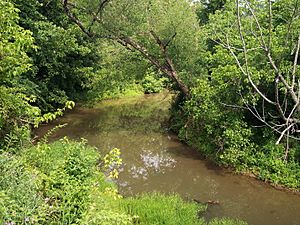
Walker Creek as viewed from the North Bend Rail Trail in Walker
|
|

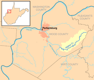
Walker Creek and its watershed in Wood County, West Virginia
|
|
| Country | United States |
| State | West Virginia |
| Counties | Wood |
| Physical characteristics | |
| Main source | east of Deerwalk 1,070 ft (330 m) 39°15′21″N 81°16′11″W / 39.2559092°N 81.2698368°W |
| River mouth | Little Kanawha River southeast of Kanawha 594 ft (181 m) 39°10′51″N 81°26′33″W / 39.1809101°N 81.4426205°W |
| Length | 15.6 mi (25.1 km) |
| Basin features | |
| Basin size | 32 sq mi (83 km2) |
Walker Creek is a stream in western West Virginia, United States. It flows into the Little Kanawha River. From there, its water travels through the Ohio River and then into the mighty Mississippi River. This means Walker Creek is part of a huge water system! The creek is about 15.6 miles (25.1 km) long. It helps drain an area of about 32 square miles (83 km2) on a part of the Allegheny Plateau that was never covered by glaciers.
About Walker Creek
Walker Creek is a tributary, which means it's a smaller stream that flows into a larger river. In this case, it flows into the Little Kanawha River. The water from Walker Creek eventually makes its way to the Ohio River and then to the Mississippi River. This whole area that the creek drains is called its watershed or drainage basin. It's like a giant funnel that collects all the rainwater and sends it into the creek.
Where Walker Creek Flows
Walker Creek is located entirely within Wood County, in the eastern part of the county. It starts its journey about 3 miles (4.8 km) east of a community called Deerwalk. The creek then flows generally towards the southeast.
It passes through the community of Walker. Finally, it joins the Little Kanawha River about 1 mile (1.6 km) southeast of the community of Kanawha. This meeting point is about 11.3 miles (18.2 km) upstream from where the Little Kanawha River itself meets the Ohio River in Parkersburg.
Nature Around the Creek
Most of the land around Walker Creek is covered by forests. About 91% of the watershed is forested, and most of these trees are deciduous. This means they are trees that lose their leaves in the fall, like oak or maple trees. The remaining 8% of the land is used for things like pastures for animals and farming.
In 1979, a part of the creek near where it starts was dammed up. This created a lake called Mountwood Park Lake, which is about 41 acres (17 ha) big. People use this lake for fun activities like fishing and boating.
You can also find the North Bend Rail Trail running alongside some parts of the lower creek. This trail used to be a railroad line for the Baltimore and Ohio Railroad. Now, it's a great place for people to walk, bike, or run and enjoy nature.
Historical Name
Over time, some places get different names. According to a system that tracks geographic names, Walker Creek has also been known as "Walker’s Creek" in the past.
 | William L. Dawson |
 | W. E. B. Du Bois |
 | Harry Belafonte |

