Walsh, Colorado facts for kids
Quick facts for kids
Walsh, Colorado
|
|
|---|---|

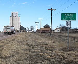
Entering from the west on Highway 160 (2019)
|
|

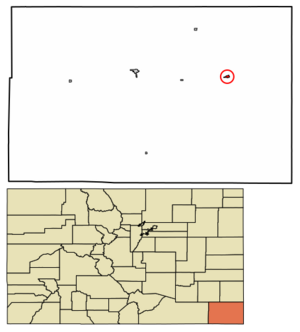
Location within Baca County and Colorado
|
|
| Country | United States |
| State | Colorado |
| County | Baca County |
| Incorporated | July 19, 1928 |
| Area | |
| • Total | 0.45 sq mi (1.16 km2) |
| • Land | 0.45 sq mi (1.16 km2) |
| • Water | 0.00 sq mi (0.00 km2) |
| Elevation | 3,960 ft (1,210 m) |
| Population
(2020)
|
|
| • Total | 543 |
| • Density | 1,207/sq mi (468.1/km2) |
| Time zone | UTC−7 (MST) |
| • Summer (DST) | UTC−6 (MDT) |
| ZIP Code |
81090
|
| Area code | 719 |
| FIPS code | 08-82460 |
| GNIS ID | 2413444 |
Walsh is a small town in Colorado, United States. It is located in Baca County. In 2020, about 543 people lived there.
History of Walsh
Walsh got its first post office in 1926. This means people could send and receive mail there. The town was named after a man named Mr. Walsh. He worked for the railroad.
Where is Walsh?
Walsh is in the eastern part of Baca County. A main road, U.S. Route 160, runs along the north side of the town. This road goes west about 20 miles to Springfield. Springfield is the main city in the county. The road also goes east about 31 miles to Johnson City, Kansas. The town of Walsh covers a total area of about 0.5 square miles.
Weather in Walsh
Walsh has a cold semi-arid climate. This means it is usually dry and can have very hot summers and cold winters. The hottest temperature ever recorded in Walsh was 109°F (43°C). This happened on July 17, 2022. The coldest temperature ever recorded was -25°F (-32°C). This happened on January 18, 1984.
| Climate data for Walsh, Colorado, 1991–2020 normals, extremes 1967–present | |||||||||||||
|---|---|---|---|---|---|---|---|---|---|---|---|---|---|
| Month | Jan | Feb | Mar | Apr | May | Jun | Jul | Aug | Sep | Oct | Nov | Dec | Year |
| Record high °F (°C) | 80 (27) |
85 (29) |
89 (32) |
96 (36) |
102 (39) |
108 (42) |
109 (43) |
106 (41) |
105 (41) |
98 (37) |
88 (31) |
78 (26) |
109 (43) |
| Mean maximum °F (°C) | 69.0 (20.6) |
73.3 (22.9) |
81.9 (27.7) |
87.4 (30.8) |
94.3 (34.6) |
101.2 (38.4) |
103.0 (39.4) |
100.3 (37.9) |
97.0 (36.1) |
90.1 (32.3) |
78.5 (25.8) |
69.6 (20.9) |
104.0 (40.0) |
| Mean daily maximum °F (°C) | 46.2 (7.9) |
50.2 (10.1) |
59.5 (15.3) |
67.6 (19.8) |
77.5 (25.3) |
88.4 (31.3) |
92.9 (33.8) |
89.7 (32.1) |
82.6 (28.1) |
69.9 (21.1) |
56.5 (13.6) |
46.5 (8.1) |
69.0 (20.5) |
| Daily mean °F (°C) | 32.6 (0.3) |
35.7 (2.1) |
44.1 (6.7) |
52.2 (11.2) |
62.3 (16.8) |
73.0 (22.8) |
77.7 (25.4) |
75.3 (24.1) |
67.7 (19.8) |
54.5 (12.5) |
42.3 (5.7) |
33.1 (0.6) |
54.2 (12.3) |
| Mean daily minimum °F (°C) | 18.9 (−7.3) |
21.3 (−5.9) |
28.6 (−1.9) |
36.7 (2.6) |
47.1 (8.4) |
57.6 (14.2) |
62.5 (16.9) |
61.0 (16.1) |
52.8 (11.6) |
39.2 (4.0) |
28.2 (−2.1) |
19.8 (−6.8) |
39.5 (4.2) |
| Mean minimum °F (°C) | 0.5 (−17.5) |
3.7 (−15.7) |
10.9 (−11.7) |
21.0 (−6.1) |
32.6 (0.3) |
45.4 (7.4) |
53.5 (11.9) |
52.2 (11.2) |
38.1 (3.4) |
22.3 (−5.4) |
9.7 (−12.4) |
1.0 (−17.2) |
−4.8 (−20.4) |
| Record low °F (°C) | −25 (−32) |
−24 (−31) |
−6 (−21) |
8 (−13) |
24 (−4) |
38 (3) |
45 (7) |
41 (5) |
20 (−7) |
7 (−14) |
−9 (−23) |
−20 (−29) |
−25 (−32) |
| Average precipitation inches (mm) | 0.46 (12) |
0.40 (10) |
1.06 (27) |
1.65 (42) |
2.12 (54) |
2.60 (66) |
3.57 (91) |
3.26 (83) |
1.43 (36) |
1.64 (42) |
0.58 (15) |
0.76 (19) |
19.53 (497) |
| Average snowfall inches (cm) | 4.5 (11) |
3.4 (8.6) |
4.2 (11) |
1.8 (4.6) |
0.2 (0.51) |
0.0 (0.0) |
0.0 (0.0) |
0.0 (0.0) |
0.0 (0.0) |
1.0 (2.5) |
2.6 (6.6) |
5.3 (13) |
23.0 (58) |
| Average extreme snow depth inches (cm) | 4.3 (11) |
3.0 (7.6) |
3.0 (7.6) |
1.7 (4.3) |
2.4 (6.1) |
0.0 (0.0) |
0.0 (0.0) |
0.0 (0.0) |
0.0 (0.0) |
0.8 (2.0) |
2.2 (5.6) |
4.4 (11) |
8.3 (21) |
| Average precipitation days (≥ 0.01 in) | 3.4 | 3.2 | 5.3 | 6.7 | 8.3 | 7.6 | 9.1 | 8.0 | 5.1 | 5.2 | 3.9 | 4.2 | 70.0 |
| Average snowy days (≥ 0.1 in) | 2.8 | 2.2 | 2.2 | 0.8 | 0.1 | 0.0 | 0.0 | 0.0 | 0.0 | 0.5 | 1.4 | 2.9 | 12.9 |
| Source 1: NOAA | |||||||||||||
| Source 2: National Weather Service× | |||||||||||||
How Many People Live in Walsh?
The number of people living in Walsh has changed over the years. In 1930, there were 454 people. The population grew to 897 people in 1950. By 2020, the population was 543 people.
| Historical population | |||
|---|---|---|---|
| Census | Pop. | %± | |
| 1930 | 454 | — | |
| 1940 | 406 | −10.6% | |
| 1950 | 897 | 120.9% | |
| 1960 | 856 | −4.6% | |
| 1970 | 989 | 15.5% | |
| 1980 | 884 | −10.6% | |
| 1990 | 692 | −21.7% | |
| 2000 | 723 | 4.5% | |
| 2010 | 546 | −24.5% | |
| 2020 | 543 | −0.5% | |
| U.S. Decennial Census | |||
See also
 In Spanish: Walsh (Colorado) para niños

