Walton Castle, Suffolk facts for kids
Quick facts for kids Walton Castle |
|
|---|---|

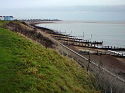
Walton Castle stood on the cliffs at Felixstowe
|
|
| Type | Saxon Shore fort |
| Location | |
| Coordinates | 51°58′20″N 1°22′48″E / 51.972151°N 1.380014°E |
| County | Suffolk |
| Country | England |
Walton Castle was an ancient Roman fort built along the coast of Britannia (which is now England). It was part of a group of forts called the Saxon Shore forts. These forts helped protect the Roman Empire from sea attacks. Later, the Normans used parts of the old Roman fort to build their own castle. Walton Castle was located high up on cliffs, about 30 meters above the sea. Sadly, the sea slowly washed away the cliffs and the castle in the 1700s. It was in a village called Walton, Suffolk, which is now part of Felixstowe.
Contents
What Was Walton Castle?
It's not completely clear if Walton Castle is one of the forts mentioned in an old Roman document called the Notitia Dignitatum. This document lists many Roman forts from the 400s. Some people thought Walton Castle might be a fort called Portus Adurni. However, today, most experts believe Portus Adurni was actually the Saxon Shore Fort at Porchester.
History of Walton Castle
Roman Times
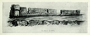
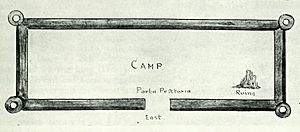
Walton Castle was a type of fort known as a Saxon Shore fort. It was probably built in the late 200s AD. Most of what we know about the fort comes from a drawing and plan made in 1623. We also have some descriptions from the 1700s.
The 1623 drawings show that Walton Castle looked similar to Burgh Castle, another Roman fort nearby. It had rounded towers that stuck out from the corners of the fort walls. The walls were made of flint stones with layers of brick in between. Having these rounded, forward-sticking towers suggests it was built around the same time as other Saxon Shore forts like Burgh Castle.
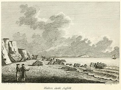
In 1722, someone described the remains of the fort. They said it was about 100 yards long and five feet above the ground. It was 12 feet wide at each end and had an angled shape. The walls were made of pebbles and Roman bricks. Many pieces of the wall had fallen onto the beach because the sea was eroding the cliff. Even at low tide, more parts of the fort could be seen in the sea.
In 1754, another description gave a more exact length for the west wall: 187 yards. It was also described as being "nine feet thick." Roman objects found near the fort suggest that a large Roman town or settlement, called a vicus, was there for a long time. It was likely a busy port too.
Medieval Period
After the Romans left, the fort was used again by the Normans. They built their own castle there, using the Roman fort's walls as a bailey (an outer courtyard). One of the Bigod earls, probably Roger Bigod of Norfolk, built this castle around 1107.
Later, Hugh Bigod, 1st Earl of Norfolk, Roger's son, made the castle stronger. However, King Henry II took control of it in the 1100s. This happened after Hugh Bigod was involved in a rebellion against the king. In 1175-1176, King Henry ordered the castle to be taken apart. Its stones were then used to help build Orford Castle. Even after this, parts of the Roman fort walls still stood. The 1623 plan shows ruins in the northeast corner, which were probably what was left of the Norman castle.
Lost to the Sea
Even though the fort was still standing in 1623, by 1722, at least one of its walls had already fallen down the eroding cliff. In a book from 1754, it was mentioned that around 1740, the west wall of the fort was still there. But by 1754, the book stated that "the Sea hath washed away the remainder of the Foundation."
When Francis Grose published his book in 1786, he included a picture drawn in 1766. This picture shows the broken pieces of the wall lying on the beach below the cliff. He wrote that the ruins were "only visible at near low water."
Today, people say that you can still see small parts of the walls. This happens during very low tides, especially during "spring tides" when the moon is full or new. These tides make the sea level drop very low, sometimes below 0.2 meters.
See also
 | Mary Eliza Mahoney |
 | Susie King Taylor |
 | Ida Gray |
 | Eliza Ann Grier |


