Wanaaring, New South Wales facts for kids
Quick facts for kids WanaaringNew South Wales |
|||||||||
|---|---|---|---|---|---|---|---|---|---|

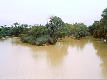
Paroo River at Wanaaring
|
|||||||||
| Population | 140 (2016 census) | ||||||||
| Postcode(s) | 2840 | ||||||||
| Elevation | 110 m (361 ft) | ||||||||
| LGA(s) | Bourke Shire | ||||||||
| State electorate(s) | Barwon | ||||||||
| Federal Division(s) | Parkes | ||||||||
|
|||||||||
Wanaaring is a small, quiet village far out in the Australian Outback. It is located in the northwest part of New South Wales, Australia. This remote spot sits right by the Paroo River. It is about 980 kilometers (over 600 miles!) from Sydney. It is also 180 kilometers west of a town called Bourke. In 2016, about 140 people lived there.
Wanaaring is on a special road called the "Cut Line." This road connects the town of Bourke with the desert village of Tibooburra. People traveling long distances often stop in Wanaaring. They can get food or refuel their vehicles here.
This village is in a very remote part of Australia. The land around it is used for farming. Farmers here raise cattle, sheep, and goats. People also produce honey in this area. There is an airport east of the village. It has a runway that can be used in all kinds of weather.
Fun Things to Do in Wanaaring
You can enjoy fishing and camping by the Paroo River. It's a great place to experience the Australian bush. Wanaaring also hosts an exciting annual event. It includes a gymkhana (horse riding games) and a rodeo. These events help raise money for the Royal Flying Doctor Service. This amazing service provides important medical help to people in remote places like Wanaaring.
Wanaaring's Past
Wanaaring is on the traditional lands of the Paaruntyi people. They are the original Aboriginal people of this area. They called this place Moukilimoultha.
In 1860, a European explorer named Vincent James Dowling first explored this region. Later, in 1862, two men, George Curlewis and McCullough, were looking for land. They were killed by local Aboriginal men near where Wanaaring is now. Another explorer, Duncan McIntyre, found and buried their remains in 1864. He learned about what happened from other Paaruntyi people. Some European settlers treated the Paaruntyi people very badly. Others hired them to work as shepherds on the new farms.
In 1867, William Malpass opened the Paroo Inn in Wanaaring. This was one of the first buildings there.
The name "Wanaaring" is believed to come from a local Aboriginal word. It means "wood duck."
Wanaaring's Weather
The climate in Wanaaring is semi-arid. This means it gets very little rain. Summers are extremely hot, and winter nights can be quite cool. Wanaaring holds an Australian record for the highest minimum temperature. On January 26, 2019, the temperature did not drop below 36.6 °C (about 98 °F)! However, it can also get cold. In July 1997, the temperature dropped to -3.9 °C (about 25 °F).
| Weather chart for Wanaaring | |||||||||||||||||||||||||||||||||||||||||||||||
|---|---|---|---|---|---|---|---|---|---|---|---|---|---|---|---|---|---|---|---|---|---|---|---|---|---|---|---|---|---|---|---|---|---|---|---|---|---|---|---|---|---|---|---|---|---|---|---|
| J | F | M | A | M | J | J | A | S | O | N | D | ||||||||||||||||||||||||||||||||||||
|
35
37
22
|
34
35
21
|
26
33
17
|
16
28
13
|
24
23
9
|
20
19
6
|
18
19
4
|
15
21
5
|
14
26
9
|
20
29
13
|
25
32
17
|
29
35
20
|
||||||||||||||||||||||||||||||||||||
| temperatures in °C precipitation totals in mm |
|||||||||||||||||||||||||||||||||||||||||||||||
|
Imperial conversion
|
|||||||||||||||||||||||||||||||||||||||||||||||
| Climate data for Wanaaring Post Office (108m elevation) 1991–2020 | |||||||||||||
|---|---|---|---|---|---|---|---|---|---|---|---|---|---|
| Month | Jan | Feb | Mar | Apr | May | Jun | Jul | Aug | Sep | Oct | Nov | Dec | Year |
| Mean daily maximum °C (°F) | 37.3 (99.1) |
35.6 (96.1) |
32.7 (90.9) |
28.2 (82.8) |
22.8 (73.0) |
19.1 (66.4) |
19.0 (66.2) |
21.4 (70.5) |
25.7 (78.3) |
29.7 (85.5) |
32.9 (91.2) |
35.4 (95.7) |
28.3 (82.9) |
| Mean daily minimum °C (°F) | 22.4 (72.3) |
21.4 (70.5) |
17.9 (64.2) |
13.3 (55.9) |
8.4 (47.1) |
5.4 (41.7) |
4.1 (39.4) |
5.1 (41.2) |
9.0 (48.2) |
13.3 (55.9) |
17.2 (63.0) |
20.1 (68.2) |
13.1 (55.6) |
| Average rainfall mm (inches) | 38.5 (1.52) |
38.8 (1.53) |
20.0 (0.79) |
14.4 (0.57) |
24.1 (0.95) |
21.1 (0.83) |
19.5 (0.77) |
13.1 (0.52) |
20.8 (0.82) |
24.6 (0.97) |
32.1 (1.26) |
29.9 (1.18) |
296.6 (11.68) |
| Average rainy days | 4.7 | 3.9 | 3.6 | 2.1 | 4.4 | 5.4 | 4.7 | 3.0 | 3.6 | 4.3 | 5.0 | 4.2 | 48.9 |
| Source: bom.gov.au | |||||||||||||
 | Charles R. Drew |
 | Benjamin Banneker |
 | Jane C. Wright |
 | Roger Arliner Young |


