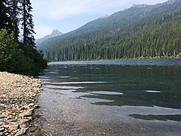
Waptus Lake facts for kids
Quick facts for kids Waptus Lake |
|
|---|---|

Shorline of Waptus Lake
|
|
| Location | Kittitas County, Washington |
| Coordinates | 47°30′12″N 121°10′41″W / 47.5033969°N 121.1779520°W |
| Primary inflows | Waptus River |
| Primary outflows | Waptus River |
| Basin countries | United States |
| Max. length | 1 mile (1.6 km) |
| Max. width | 0.2 miles (0.32 km) |
| Surface area | 255.2 acres (1.033 km2) |
| Surface elevation | 2,792 ft (851 m) |
Waptus Lake is a beautiful freshwater lake high up in the mountains. It's found in Kittitas County, Washington, within the southern part of the Okanogan National Forest. Many people love to visit Waptus Lake for hiking, camping, and fishing. This is because it's close to Cooper Lake and the famous Pacific Crest Trail. Waptus Lake is surrounded by trails that lead to other mountain lakes nearby. These include Pete Lake and Spectacle Lake, which are at the base of Chikamin Peak.
About Waptus Lake
Waptus Lake is one of the biggest lakes in the Alpine Lakes Wilderness. It sits in a large valley. The lake stretches about 1 mile long and 0.2 miles wide. The Waptus River flows into and out of the lake. This river is also one of the streams that feed into the Cle Elum River.
For a while, mining and building dams affected the homes of salmon in the Cle Elum River. However, since the late 2000s, many salmon have been returning to lay their eggs there.
History of the Area
In 1984, a special stone tool called a Clovis point was found at the bottom of the Cle Elum Reservoir. This area is south of Waptus Lake. This discovery suggests that ancient people, possibly the Wenatchi People, might have lived here. The Wenatchi are part of the Confederated Tribes of the Colville Reservation. This land is also within the traditional lands of the Yakama Nation.
Even though the Clovis point was found, there hasn't been more proof from other tools or structures. The water levels haven't gone down enough since 1984 to check the area where the point was found. Other old Native American sites have been found nearby. These include places with old tools, petroglyphs (rock carvings), and areas where people gathered resources. There were also seasonal camps for catching salmon. These sites suggest that the Kittitas or other Yakama Nation groups used to live or visit these lands.
Weather Around Waptus Lake
Waptus Lake has a climate that is a mix of forest and ocean weather. It's part of the marine west coast climate zone in western North America. The average temperature around the lake is 3° Celsius (37° Fahrenheit).
The warmest month is August, with an average temperature of 19° Celsius (66° Fahrenheit). The coldest month is January, with an average of −8° Celsius (18° Fahrenheit). On average, the area gets about 1687 millimeters (66 inches) of rain each year. December is the wettest month, with 247 millimeters (9.7 inches) of rain. July is the driest, with only 33 millimeters (1.3 inches) of rain.
|
||||||||||||||||||||||||||||||||||||||||||||||||||||||||||||||||||||||||||||||||||||||||||||||||
How to Visit Waptus Lake
Hiking to Waptus Lake is a very popular activity. The lake is right next to the famous Pacific Crest Trail. The hike starts from the Salmon La Sac Trailhead and is about 8 miles long. The trail is mostly gentle, with a few steeper parts.
The path follows a valley floor through an old-growth forest. You will often cross small creeks that are fed by melting snow. Remember, mountain bikes are not allowed past the wilderness boundary. The trail connects with Trail Creek Trail 1322 and then Waptus Pass Trail 1329. This leads to the lake. There used to be a bridge, but it was washed away by a flood. The trail continues a short distance upstream as Waptus Horse Ford Trail 1329.1 and eventually reaches the Pacific Crest Trail 2000.


