
Wartau facts for kids
Quick facts for kids
Wartau
|
||
|---|---|---|

View of the ruined Wartau castle, looking south-east across the Rhine Valley towards Mittagspitz
|
||
|
||

Wartau
Location in Switzerland

Wartau
Location in Canton of St. Gallen
|
||
| Country | Switzerland | |
| Canton | St. Gallen | |
| District | Werdenberg | |
| Area | ||
| • Total | 41.75 km2 (16.12 sq mi) | |
| Elevation | 468 m (1,535 ft) | |
| Population
(Dec 2020 )
|
||
| • Total | 5,296 | |
| • Density | 126.850/km2 (328.54/sq mi) | |
| Postal code |
9476-9479
|
|
| Surrounded by | Balzers (LI), Flums, Mels, Sargans, Sevelen, Triesen (LI), Walenstadt | |

Wartau is a small town, also called a municipality, in the Werdenberg area of the Swiss canton of St. Gallen. It's made up of several villages located on the eastern side of the Alvier mountains, right next to the Alpine Rhine river.
Contents
Exploring Wartau's Geography

Wartau is home to several villages. Some, like Azmoos (482 m), Trübbach (478 m), and Weite (469 m), are found along the Rhine River. Others, such as Oberschan (668 m), Malans (617 m), Gretschins (600 m), and Fontnas (542 m), are nestled in the foothills of the Alvier mountain range.
There are also smaller settlements called hamlets, like Plattis (464 m) and Murris (470 m). Matug (731 m) and its surroundings were historically settled by the Walser people, who lived in scattered homes.
How Land is Used in Wartau
Wartau covers an area of about 41.74 square kilometers. A large part of this land, about 45.8%, is used for farming. Forests cover another big portion, about 38.4% of the area.
About 6.8% of Wartau's land is developed with buildings and roads. The remaining 9.0% is unproductive land, meaning it's not used for farming or building. The highest point in Wartau is the Alvier peak, which stands at 2,343 meters (7,687 ft) tall. The lowest point is in the Rhine Valley, at 461 meters (1,512 ft).
Wartau's Population and People
Wartau has a population of about 5,500 people. In 2015, about 28.6% of the people living in Wartau were foreign nationals. A small number of these residents were born in Germany (6.1%) or Italy (5.2%).
Over five years, from 2010 to 2015, Wartau's population grew by about 3.73%. In 2015, the birth rate was 10.5 births per thousand residents, and the death rate was 8.6 deaths per thousand residents.
Who Lives in Wartau?
In 2015, children and teenagers (ages 0–19) made up 22.5% of Wartau's population. Adults (ages 20–64) were the largest group at 61.1%, and seniors (over 64 years old) made up 16.4%.
Most people in Wartau speak German, which is spoken by about 88.5% of the population. Other languages spoken include Albanian (3.2%) and Italian (2.9%).
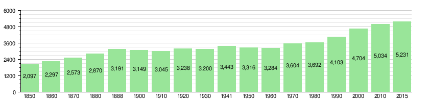
How Wartau's Population Has Changed Over Time
The chart below shows how the number of people living in Wartau has changed through history:
A Look into Wartau's History


People have lived in the Wartau area for a very long time, even since the Stone Age and Bronze Age. The name Wartau comes from Wartau Castle, which was built in 1225. The main center of the area in the Middle Ages was Gretschins, where a church was first mentioned in 1273.
Over the centuries, control of Wartau changed hands many times. In the 14th century, the higher parts of the area were settled by the Walser people. A ferry used to cross the Rhine between Trübbach and Balzers. Later, a road was built along the Rhine in 1491/92.
Religious Changes and Conflicts
The church in Gretschins was dedicated to Saint Martin in 1494. However, the people of Wartau quickly adopted the Swiss Reformation in the 1520s, changing their religion from Catholic to Protestant.
Later, in 1694/95, there was a conflict called the "Wartau conflict" when people tried to bring back the Catholic mass. This almost started a bigger religious war in Switzerland! A second church was built in Azmoos in 1736.
Wartau's Coat of Arms
The official symbol of Wartau, its coat of arms, has been around since at least 1632. It shows a green grapevine with leaves and a gold star on a red background. This design was chosen again in the 1970s after a different design showing the castle ruins was used for a short time.
Becoming a Modern Municipality
In 1802, there was a short-lived "Republic of Wartau." Then, in 1803, the modern municipality of Wartau was formed as part of the Swiss canton of St. Gallen. The Walser people living in the area officially became citizens in 1827.
Over time, transportation improved. Railway stations were built in Trübbach and Weite in 1858. The Rhine ferry was replaced by a bridge in 1872, and the A13 motorway was built in 1967.
Learning and Education in Wartau
Many adults in Wartau have a good education. About 70.2% of people aged 25–64 have finished either a non-mandatory upper secondary education or have gone on to higher education, like university.
Looking at the whole population in 2000, about 21.1% had finished primary school. A larger group, 37.4%, had completed their secondary education. About 9.4% had attended a tertiary school (like a university or college).
Wartau's Economy and Jobs
Wartau is known as an industrial community. This means that making things (manufacturing) provides more than a quarter of all the jobs in the area.
In 2014, there were 1,886 people working in Wartau.
- About 194 people worked in 49 businesses related to the primary economic sector, which includes farming and forestry.
- The secondary sector, which involves manufacturing and construction, employed 771 workers in 67 businesses.
- The tertiary sector, which includes services like shops, hotels, and offices, provided 921 jobs in 229 businesses.
In 2011, the unemployment rate in Wartau was 2%, which means very few people were looking for jobs. In 2015, hotels in Wartau had over 5,500 overnight stays, with a small portion of those visitors coming from other countries.
Religion in Wartau
The church in Gretschins was likely built in the early 13th century. It was rebuilt in 1494 and dedicated to Saint Martin. The people of Wartau adopted the Swiss Reformation in the 1520s, becoming Protestant. They even resisted attempts to bring back Roman Catholicism in the 17th century.
A Catholic church was built in Azmoos in 1892, and the number of Catholic residents slowly grew. By the late 20th century, the numbers of Catholics and Protestants were almost equal. In 2000, about 42% of the population was Catholic, and 38% belonged to the Swiss Reformed Church (Protestant).
Wartau has also welcomed many immigrants since the late 20th century. In 2000, about 7.8% of the population identified as Muslim. Also, 5.5% of people said they were not religious.
Important Heritage Sites in Wartau

Wartau is home to several important historical sites. The Gretschins-Herrenfeld and Ochsenberg areas have traces of very old settlements and sacrifice sites from prehistoric times.
The ruins of Wartau Castle are also a significant historical landmark. Another important site is the Walser Rathaus (town council house) auf Palfries. These places are listed as Swiss heritage sites of national significance.
Additionally, the villages of Azmoos and Oberschan, along with the hamlets of Fontnas and Gretschins, are recognized as part of the Inventory of Swiss Heritage Sites. This means they have special cultural importance.
See also
 In Spanish: Wartau para niños
