Watkins, Colorado facts for kids
Quick facts for kids
Watkins, Colorado
|
|
|---|---|

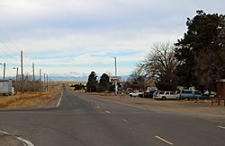
Watkins, looking west along Colfax Avenue.
|
|

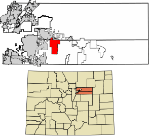
Location of the Watkins CDP in Adams County and Arapahoe County, Colorado.
|
|
| Country | |
| State | |
| Counties | Adams & Arapahoe |
| Government | |
| • Type | unincorporated town |
| Area | |
| • Total | 24.753 sq mi (64.109 km2) |
| • Land | 24.753 sq mi (64.109 km2) |
| • Water | 8×10⁻⁵ sq mi (0.0002 km2) |
| Population
(2020)
|
|
| • Total | 682 |
| • Density | 27.553/sq mi (10.638/km2) |
| Time zone | UTC-7 (MST) |
| • Summer (DST) | UTC-6 (MDT) |
| ZIP Code |
80137
|
| Area codes | 303 & 720 |
| GNIS feature | Watkins CDP |
Watkins is a small community in Colorado, United States. It is also known as Box Elder. Watkins is not a city with its own government. Instead, it is an unincorporated town. This means it is governed by the counties it is in.
Watkins is located across two counties: Arapahoe and Adams. It is also a census-designated place (CDP). This means the U.S. Census Bureau counts its population. Watkins is part of the larger Denver–Aurora–Lakewood, CO Metropolitan Statistical Area. This area includes Denver and its nearby towns. The community is close to Aurora. The Watkins post office uses the ZIP Code 80137. In 2020, about 682 people lived in Watkins.
History of Watkins
The Watkins post office first opened in 1878. The community was named after L. A. Watkins. He was a cattleman in the area. For a long time, Watkins was an unincorporated community. This means it did not have its own town government.
In 2004, Watkins officially became a town. This happened on June 15. However, the people of Watkins later voted on it. On November 7, 2006, they decided to go back. They voted to become an unincorporated community again. This means the county governments now manage the area.
Watkins is working on building the first park in Adams County. The Watkins Historical Preservation Society is helping. They plan to move some old buildings to the park. The Colorado Air and Space Port is also located near Watkins.
Watkins by the Numbers
The Watkins CDP covers an area of about 64.109 square kilometers. This is roughly 15,841 acres. Only a tiny part of this area is water.
Population Changes
The United States Census Bureau first counted Watkins as a CDP in 2010. The population has grown a little since then.
| Watkins CDP, Colorado | ||
|---|---|---|
| Year | Pop. | ±% |
| 2010 | 653 | — |
| 2020 | 682 | +4.4% |
| Source: United States Census Bureau | ||
Education in Watkins
Most students in Watkins attend schools in the Bennett School District 29-J. A smaller part of the community is in the Adams-Arapahoe School District 28J.
Students in the Adams-Arapahoe 28J area go to specific schools. These include Harmony P-8 School. They also attend Vista PEAK Preparatory School.
See also

- In Spanish: Watkins (Colorado) para niños
 | Georgia Louise Harris Brown |
 | Julian Abele |
 | Norma Merrick Sklarek |
 | William Sidney Pittman |


