Watshishou River facts for kids
Quick facts for kids Watshishou River |
|
|---|---|

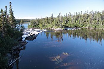
The river from Route 138
|
|
| Native name | Rivière Watshishou |
| Country | Canada |
| Province | Quebec |
| Region | Côte-Nord |
| RCM | Minganie |
| Physical characteristics | |
| River mouth | Gulf of Saint Lawrence 50°16′09″N 62°41′28″W / 50.269303°N 62.691008°W |
| Length | 80 kilometres (50 mi) |
| Basin features | |
| Basin size | 1,044 square kilometres (403 sq mi) |
The Watshishou River, also known as French: Rivière Watshishou in French, is a special river in eastern Quebec, Canada. It's famous for its salmon! This river flows through the beautiful Côte-Nord region.
Contents
Where is the Watshishou River?
The Watshishou River starts in Lake Watshishou. It then flows south, passing through Lake Holt and Little Lake Holt. Finally, it empties into the Gulf of Saint Lawrence.
River Size and Path
The river is about 80 kilometers (50 miles) long. It gets water from many other lakes along its path. The area it drains, called its basin, covers about 1,044 square kilometers (403 square miles).
Nearby Towns and Features
Quebec Route 138 crosses the river close to where it meets the sea. The river flows into the Jacques Cartier Strait. This is between the towns of Havre-Saint-Pierre and Natashquan. It's just west of the Little Watshishou River.
Higher up, the river flows through a wild area called Lac-Jérôme. Further down, it passes through the town of Aguanish. The river's mouth is in the town of Baie-Johan-Beetz. This area is part of the Minganie Regional County Municipality.
Surrounding Areas
The Watshishou River basin is located between two other river basins. To the west is the Véronique River, and to the east is the Little Watshishou River. The river basin also includes special old forests. These are the Nabisipi River Old Forest and the Lake Davy Old Forest.
Near the coast, the land is mostly flat. It gently slopes down to the Gulf of Saint Lawrence. The highest points in the last 15 kilometers (9 miles) are less than 150 meters (490 feet) high. East of Watshishou Harbor, there's a hill called Morne Watshishou. It stands out at over 60 meters (200 feet) tall.
What Does "Watshishou" Mean?
The name Watshishou has a long history. It might be the same as "R. Oueachechou" from a map made in 1715. Later maps spelled it in different ways, like Watsheeshou or Watchichou.
Meaning in Innu Language
In the Innu language, Watshishou likely means "white mountain" or "bright mountain." This probably refers to a smooth, shiny granite hill. This hill, called Watshishou Hill, is 45 meters (148 feet) high. It's located east of the river's mouth.
Some people think the word comes from watsh (mountain) and shu (small). If so, it would mean "small mountain." Another Innu name for the river is Uetiheu Hipu. This name means "it rejoins."
Fishing in the Watshishou River
The Watshishou River is a great place for fishing. There's a place called Lac Holt Fishing Lodge. You can reach it by a special plane that lands on water, called a float plane. These planes take off from Havre-Saint-Pierre.
What Fish Can You Catch?
At the lodge, you can fish from boats or by wading in the water below rapids. The types of fish you might catch include:
- Brook trout (Salvelinus fontinalis)
- Arctic char (Salvelinus alpinus)
- Landlocked Atlantic salmon (Salmo salar)
In 2018, a report said the river's salmon population was "Not Threatened With Loss." This means the salmon here were doing well.
Protecting Salmon
In May 2015, the Quebec government started a special program. It was for sport fishing of large salmon on 16 rivers. These rivers included the Watshishou. The program asked anglers to catch and then release large salmon. This helps protect the salmon population.
However, some groups felt this wasn't enough. They believed that to truly protect Atlantic salmon, catch-and-release should be used on almost all rivers. This was because the number of Atlantic salmon was quickly going down.
 | Jackie Robinson |
 | Jack Johnson |
 | Althea Gibson |
 | Arthur Ashe |
 | Muhammad Ali |


