
Wauneta, Nebraska facts for kids
Quick facts for kids
Wauneta, Nebraska
|
|
|---|---|
|
Village
|
|

Downtown Wauneta: Tecumseh Avenue, looking north
|
|

Location of Wauneta, Nebraska
|
|
| Country | United States |
| State | Nebraska |
| County | Chase |
| Area | |
| • Total | 0.97 sq mi (2.51 km2) |
| • Land | 0.97 sq mi (2.51 km2) |
| • Water | 0.00 sq mi (0.00 km2) |
| Elevation | 2,959 ft (902 m) |
| Population
(2020)
|
|
| • Total | 549 |
| • Density | 566.56/sq mi (218.81/km2) |
| Time zone | UTC-7 (Mountain (MST)) |
| • Summer (DST) | UTC-6 (MDT) |
| ZIP code |
69045
|
| Area code(s) | 308 |
| FIPS code | 31-51700 |
| GNIS feature ID | 2400109 |
Wauneta is a small village located in Chase County, Nebraska. In 2020, about 549 people lived there. It is found along U.S. Route 6, southeast of Imperial. Imperial is the main town, also known as the county seat, of Chase County. Wauneta is about 2,959 feet (902 meters) above sea level. Its ZIP code is 69045.
Contents
History of Wauneta
The first European settlers arrived in Wauneta in 1875. George Rowley and his wife built a sod house near the Wauneta Falls. A sod house is a home made from blocks of grass and soil.
The first post office in Wauneta opened in 1877. Since 1886, Wauneta has always had a post office. The local newspaper, called “The Wauneta Breeze,” has been serving the community since 1887.
Railroad and Growth
The railroad reached Wauneta in 1892. This train line was built by a part of the Chicago, Burlington and Quincy Railroad. The line connected to the main railroad near Culbertson and ended in Imperial. The arrival of the railroad helped the village grow.
Historic Places in Wauneta
There are two places near Wauneta that are listed on the National Register of Historic Places. This means they are important historical sites.
- The Wauneta Roller Mills was added to the list in 2008.
- The Lovett Site was added in 1972 and is located northwest of Wauneta.
Geography of Wauneta
Wauneta is a small village with a total area of about 0.97 square miles (2.51 square kilometers). All of this area is land. There are no large bodies of water within the village limits.
Population of Wauneta
The number of people living in Wauneta has changed over the years. Here is a look at the population from 1900 to 2020:
| Historical population | |||
|---|---|---|---|
| Census | Pop. | %± | |
| 1900 | 181 | — | |
| 1910 | 327 | 80.7% | |
| 1920 | 572 | 74.9% | |
| 1930 | 793 | 38.6% | |
| 1940 | 770 | −2.9% | |
| 1950 | 926 | 20.3% | |
| 1960 | 794 | −14.3% | |
| 1970 | 738 | −7.1% | |
| 1980 | 746 | 1.1% | |
| 1990 | 675 | −9.5% | |
| 2000 | 625 | −7.4% | |
| 2010 | 577 | −7.7% | |
| 2020 | 549 | −4.9% | |
| U.S. Decennial Census | |||
What the 2010 Census Showed
In 2010, there were 577 people living in Wauneta. These people lived in 269 households, and 150 of these were families. The village had about 595 people per square mile. There were 307 housing units, which are places where people live.
Most of the people in Wauneta were White (95.7%). A small number were African American (0.2%) or Asian (0.2%). About 3.5% were from other races, and 0.5% were from two or more races. About 6.6% of the population identified as Hispanic or Latino.
Households and Age
Out of the 269 households:
- 21.6% had children under 18 living there.
- 46.8% were married couples living together.
- 6.3% had a female head of the household with no husband.
- 2.6% had a male head of the household with no wife.
- 44.2% were not families.
About 39.8% of all households had only one person living in them. And 21.2% of households had someone aged 65 or older living alone. The average household had about 2 people, and the average family had about 2.7 people.
The average age of people in Wauneta was 50.4 years old.
- 18.7% of residents were under 18.
- 5.8% were between 18 and 24.
- 17.9% were between 25 and 44.
- 24.9% were between 45 and 64.
- 32.6% were 65 years or older.
The village had slightly more females (53.9%) than males (46.1%).
Images for kids
-
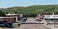
Downtown Wauneta: Tecumseh Avenue, looking north
-
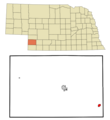
Location of Wauneta, Nebraska
-

A friendly robot

See also
 In Spanish: Wauneta (Nebraska) para niños
